Download
1 / 18
180 likes | 299 Vues
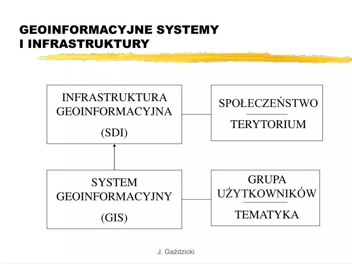
GEOINFORMACYJNE SYSTEMY I INFRASTRUKTURY. INFRASTRUKTURA GEOINFORMACYJNA (SDI). SPOŁECZEŃSTWO TERYTORIUM. GRUPA UŻYTKOWNIKÓW TEMATYKA. SYSTEM GEOINFORMACYJNY (GIS). TERYTORIA. CZĘŚĆ PAŃSTWA (MIASTO, WOJEWÓDZTWO) PAŃSTWO (POLSKA) GRUPA PAŃSTW (UNIA EUROPEJSKA - INSPIRE)

E N D
GEOINFORMACYJNE SYSTEMY I INFRASTRUKTURY INFRASTRUKTURA GEOINFORMACYJNA (SDI) SPOŁECZEŃSTWO TERYTORIUM GRUPA UŻYTKOWNIKÓW TEMATYKA SYSTEM GEOINFORMACYJNY (GIS) J. Gaździcki
TERYTORIA • CZĘŚĆ PAŃSTWA (MIASTO, WOJEWÓDZTWO) • PAŃSTWO (POLSKA) • GRUPA PAŃSTW (UNIA EUROPEJSKA - INSPIRE) • ŚWIAT (GSDI) J. Gaździcki
DEFINICJE SDI • Infrastruktura geoinformacyjna (SDI): • jest zespołem technologii, środków politycznych i ekonomicznych oraz przedsięwzięć instytucjonalnych, które ułatwiają dostęp do danych przestrzennych oraz korzystanie z nich ... (GSDI) • stanowi całokształt środków służących do racjonalnego gospodarowania danymi przestrzennymi oraz zmierzających do efektywnego stosowania tych danych ... zapewniając dostęp do nich ... (Leksykon geomatyczny) J. Gaździcki
CHARAKTERYSTYKA ESDI Inicjatywa INSPIRE zmierza do utworzenia Europejskiej Infrastruktury Danych Przestrzennych (ESDI) dostarczającej użytkownikom zintegrowane usługi geoinformacyjne, np. w zakresie wizualizacji i łączenia informacji oraz dokonywania analiz przestrzennych i czasowych. Usługi te powinny umożliwiać użytkownikom wyszukiwanie i uzyskiwanie geoinformacji w sposób interoperowalny dla różnych celów, korzystając z różnych źródeł na poziomach od lokalnego do globalnego. ESDI obejmie odpowiednią politykę i organizację, dane i technologie, standardowe mechanizmy przekazu oraz finansowe i ludzkie zasoby, które niezbędne są do tego, aby zaspokojone zostały potrzeby wszystkich użytkowników geoinformacji. Zintegrowane usługi geoinformacyjne realizowane będą w sieci baz danych powiązanych wspólnymi standardami i protokółami. J. Gaździcki
INFORMACJA O ŚRODOWISKU • Jest to informacja w dowolnej postaci dotycząca: • stanu elementów środowiska - powietrza, wody, gleby ... • czynników oddziałujących na elementy środowiska - substancji, energii, hałasu ... • środków i działań, w tym politycznych, prawnych i administracyjnych, mających wpływ na środowisko i jego ochronę • analiz kosztów i korzyści stanowiących podstawę wymienionych środków i działań • oddziaływania środowiska na zdrowie i bezpieczeństwo ludności, obiekty kultury ... J. Gaździcki
ROLA PAŃSTWA CZŁONKOWSKIEGO Każde uczestniczące państwo odpowiada za utworzenie i funkcjonowanie państwowej infrastruktury geoinformacyjnej obejmującej metadane, dane podstawowe (referencyjne) i tematyczne (środowiskowe). Dane te mają być dostępne elektronicznie z zastosowaniem usług katalogowych oraz wizualizacyjnych ... (INSPIRE) J. Gaździcki
OCENA STANU PRZEDSIĘWZIĘĆ WIĄŻĄCYCH SIĘ Z INFRASTRUKTURĄ GEOINFORMACYJNĄ • studia i koncepcje • projekty • próby • inicjatywy • pilotaże • częściowe/pełne funkcjonowanie • dalszy rozwój J. Gaździcki
KRYTERIA INICJATYWY SDI • istnienie i dostępność strategii tworzenia infrastruktury • skuteczna koordynacja • szerokie zainteresowanie i uczestnictwo • promocja (popularyzacja, dokumentacja, dostęp) • finansowanie (realne środki, konkretny plan) • partnerstwo (umowy o współpracy) J. Gaździcki
KONSULTACJA W RAMACH ZIG • odpowiedzi na kluczowe pytania dokumentu konsultacyjnego powinny być ograniczone do spraw istotnych, zwłaszcza dotyczących Polski, • propozycje odpowiedzi należy przesyłać do PTIP w języku polskim i w miarę możliwości w języku angielskim do 14.05 (E.Musiał, tel. i e-mail w zaproszeniu) • zbiorcze zestawienie odpowiedzi w języku angielskim, po wyjaśnieniu ewentualnych wątpliwości i życzeń Autorów propozycji, zostanie przekazane zainteresowanym po 20.05 (preferowana forma: publikacja na stronie internetowej) J. Gaździcki
PYTANIE 1 Do you agree with the five INSPIRE principles? Str. 13 Spatial data should be of appropriate quality, collected once, updated and managed maintained at the level where this can be done most effectively It must be possible to combine seamlessly spatial data from different sources across the EU and share it between many users and applications to meet the needs ofthe information society Uwaga: kolorem czerwonym oznaczane są wstępne propozycje zmian oraz komentarze, kolorem zielonym - skreślenia. J. Gaździcki
PYTANIE 2 • Are these the five main obstacles that prevent the widespread use of spatial data to support environmental governance? Yes. • Do they exist at local, regional, national and international level? Yes. They are critical mostly at local and regional level. • Should they be addressed by INSPIRE? Yes. • Str. 14 J. Gaździcki
PYTANIE 3 • Do we cover all the necessary themes? Yes, this scope is satisfactory. However, public and private organisations which maintain other themes or components shall be encouraged to make their spatial datasets compatible with the INSPIRE datasets and ensure interoperability (ref. key question 11). • Str. 15 (17 themes), aneks 1 (60 components), aneks 2 (quality requirements), aneks 4 (descriptions and uses) • COMPONENTS: • 30 core components (datasets) - primary data (topographical, thematic), intermediate data (medium scale, small scale) • 30 other components • LATESTREALISATION: 2006 - 2015 J. Gaździcki
PYTANIE 4 Is it appropriate that INSPIRE focuses on spatial data for which the public sector bodies are responsible without, however, excluding collaboration with the private sector where relevant by creating an open Spatial Data Infrastructure to which all stakeholders can contribute? Yes, see answer to question 3. J. Gaździcki
PYTANIE 5 • Do you agree that the identified core data components have high priority? • We are of the opinion that high priority shall be assigned additionally to: • 1.1 Geographical Geodetic reference systems • 2.3 Block, census and statistical districts • 2.4 Civil security units (?) J. Gaździcki
PYTANIE 6 Do you consider that in the future, legal initiatives need to be taken to ensure that certain spatial data fully covers the EU territory in accordance with agreed data collection methods and quality criteria such as those referred to in Annex 2 of the INSPIRE document? In principle yes, but further investigation is required. Are the core datasets referred to above the most relevant ones in the context of INSPIRE? See answer to question 5. J. Gaździcki
PYTANIE 7 Is the knowledge on the existing public sector spatial datasets that correspond to the themes in Annex 1 needed to unlock their potential to support the widest possible re-use? Yes. J. Gaździcki
PYTANIE 8 Is the establishment of common specifications and the building of bridges between existing datasets and these common specifications useful to increase the potential of re-using public sector spatial data? Yes. J. Gaździcki
PYTANIE 9 Should certain information on standards and key components of data be made available free of charge and free of restriction on use in order to encourage their use by a wide range of data providers? Yes. J. Gaździcki