Considerations for Testing GLONASS
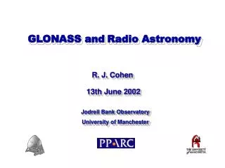
Mount Hood, Oregon Photo by Daryl Moistner www.nevadasurveyor.com. Considerations for Testing GLONASS. Ken Bays, PLS Lead Geodetic Surveyor, Oregon DOT 2014 ODOT Surveyors Conference 1 April 2014. Overview. Why test GLONASS? What do we want to test? Who is involved in the testing?


Considerations for Testing GLONASS
E N D
Presentation Transcript
Mount Hood, Oregon Photo by Daryl Moistner www.nevadasurveyor.com Considerations for Testing GLONASS Ken Bays, PLS Lead Geodetic Surveyor, Oregon DOT 2014 ODOT Surveyors Conference 1 April 2014
Overview Why test GLONASS? What do we want to test? Who is involved in the testing? Issues with GLONASS Planning for testing Issues with testing
What does the acronym GPS stand for? • Global PositioningSystem • Generally accepted as the name for U.S. GNSS system • What does the acronym GNSS stand for? • Global Navigation SatelliteSystem • Generic term for the satellite navigation system of any nation.
What is the more specific acronym for the US GPS system? • NAVSTAR • What does NAVSTARstand for? • NAVigationSatellite Timing And Ranging
What does GLONASS mean: • Global'nayaНавигатсайоннаяСпутниковаяСистема • = • Global'nayaNavigatsionnayaSputnikovaya Sistema • = • Global Orbiting Navigation Satellite System
Why test GLONASS • Evaluate when Oregon DOT surveyors should or should not use GLONASS • Should we add GLONASS capability to the Oregon Real-time GPS Network? • Benefit to surveyors to know more about the solutions they are using. • Varying manufacturer claims • Lots of anecdotal claims and “back-of-the-envelope” tests out there
What do we want to test • Testing Productivity • Does it alwayshelp to add GLONASS? • Will GLONASS always enable a solution in heavy canopy when GPS-only won’t yield a solution?
What do we want to test • Testing Accuracy • Is accuracy the same, worse, or better than GPS-only in open and closed canopy. • Some older papers suggest GLONASS degrades accuracy of GPS-only solutions • But remember the GLONASS constellation was down to 6 or 7 satellites a few years ago. • Leica GS14 datasheet claims “GPS and GLONASS can increase performance AND accuracy by up to 30% relative to GPS only”. • Is the claimed accuracy increase the same in and out of canopy? • Other papers report little accuracy difference when adding GLONASS to GPS-only.
Who is involved in the testing? • Geometronics Unit, Oregon DOT • Operating the Oregon Real-time GPS Network • Oregon State University • Dan Gillins, Assistant Professor, PhD, PLS • Submitted abstract to ION for GNSS+ 2014 Conference • Michael Eddy: graduate thesis • Processing long static baselines w/ and w/o GLONASS
32 NAVSTAR 24 GLONASS 15 BeiDou 4 Galileo
Issues with GLONASS • Time tags and receiver clock offsets: GPS time vs GLONASS time • Reference datum offsets from GPS (WGS84) to GLONASS (PZ-90.02) • GLONASS FDMA format vs the CDMA format for GPS and Galileo • New Russian K satellites will be CDMA • Different manufacturers have different, usually proprietary, solutions for handling these biases
Issues with GLONASS • Very limited GLONASS tracking/monitoring network worldwide; mostly within Russia • Russia plans to add world wide tracking stations • Current political situation could inhibit GPS/Galileo cooperation with GLONASS • 2013 State Dept. negotiations to establish GLONASS monitor station in US already blocked by Congress. • No GLONASS plan for new signal in L5 Band • L5 is a Safey-of-Life protected frequency • L5 is supported by GPS, Galileo and Beidou • Management & corruption issues • 2010: Dismissal of two high-ranking space officials • 2010: Resignation of head of Russian Space Agency (Roscosmos) • After the first launch failure of 3 GLONASS SVs • 2012: Designer for GLONASS sacked: $17 million embezzlement • siphoned GLONASS R & D funds with fake orders/phony companies • 2013: Investigation of $12 million embezzlement • M2M Telematics, part of Russian GLONASS system
Russian GLONASS/GNSS Forum’s Questionairrehttp://aggf.ru/pr.php?nn=5375 As reported on-line by in GPS World magazine: http://gpsworld.com/survey-seeks-suggestions-on-future-of-glonass “4. Являетсяливажным с точкизренияконкурентоспособности, чтобы КА системы ГЛОНАСС, в дополнение к запланированнымновымкодовымсигналам в традиционныхдиапазонах ГЛОНАСС (L1, L2, L3) передавалибыеще и сигнал в диапазоне L5? Почему? Еслида, тодлякакихпотребителейэтоважно?”
Russian GLONASS/GNSS Forum’s Questionairrehttp://aggf.ru/pr.php?nn=5375 As reported on-line by in GPS World magazine: http://gpsworld.com/survey-seeks-suggestions-on-future-of-glonass and translated by Richard Langley, Innovations Editor for GPS World: “4. Is it important in terms of competitiveness, for the GLONASS satellites, in addition to the planned new code signals in the traditional GLONASS bands (L1, L2, L3) to add another signal in the range L5? Why? If yes, for which consumers is this important?”
Issues with GLONASS • Availability of real-time precise ephemerides for GLONASS?
Oregon Real-time GPS Network software automatically downloads the predicted half of the Ultra-Rapid ephemerides four times daily and incorporates them into our network (multi-base) real-time correctors. Will real-time precise GLONASS ephemerides be available for RTNs ???
IGS MGEX (Multi GNSS Experiment)http://igs.org/mgex/ • The Multi-GNSS Experiment (MGEX) has been set-up by the International GNSS Service (IGS) to track, collate and analyze all available GNSS signals. This includes signals from the BeiDou, Galileo and QZSS systems, as well as from modernized GPS and GLONASS satellites and any space-based augmentation system (SBAS) of interest. • Analysis centers will attempt to estimate inter-system calibration biases, compare equipment performance and further develop processing software capable of handling multiple GNSS observation data. • The development of multi-GNSS IGS products.
Planning for testing • Letters to manufacturers • How do their products use GLONASS in RTK and postprocessing. • Supplemental to GPS or equal to GPS • Investigate prior research • White papers • ION GNSS presentation archives • E-mail: Dan Gillins, OSU, to Dr Neil Weston, Deputy Director, NGS
E-mail: Dr Neil Weston, Deputy Director, NGS,to Dan Gillins, OSU • NGS has not done too much with respect to GPS +GLONASS processing • NGS has spent a few months looking at the Pages software (NGS) to see how GLONASS can be incorporated • NGS hopes to add GLONASS (to their products such as OPUS) and also focus on Galileo • With respect to helping out with a study, NGS cannot offer too much other than CORS data with GPS+GLONASS. • Do you have more specific ideas in mind?
NGS testing and evaluation of GLONASS would help real-time network administrators and also surveyors in general
Planning for Testing • Perform enough test repetitions to yield statistically valid results. • Publish accuracy analysis at the 95% confidence level per FGDC Geospatial Positioning Accuracy Standards. • http://www.fgdc.gov/standards/projects/FGDC-standards-projects/accuracy/
Planning for testing Testing in open, medium, and heavy canopy. Establish accurate test networks in canopy with total station network tied to accurate static GPS sites in open canopy.
US Forest Service Clackamas GPS Test NetworkMt. Hood National Forest
US Forest Service Clackamas GPS Test NetworkMt. Hood National Forest
Issues with testing • Testing can’t cover all brands of GPS receivers • Different GPS RTN softwares handle GLONASS differently • As GNSS constellations change, ongoing testing will be needed • GPS new CNAV Signals, ie. L5 stronger signal strength is supposed to help in canopy. • GLONASS: CDMA?, L5?, worldwide tracking/monitoring? • BEIDOU: coming on strong ? • Galileo: just around the corner ?????? • Manufacturers will adopt new and better processing algorithms to better take advantage of various GNSS • All these changes will point out the need for ongoing testing. • Test networks with accurately positioned marks will continue to be valuable.
Oregon Real-time GPS Network www.TheORGN.net ORGN@odot.state.or.us The beach at Bandon, Oregon
Did you get a fix on four Galileo satellites? Then there could be a certificate in it for you! ESA will recognize Galileo pioneers with commemorative certificates to the first 50 entities who document their achievement of a past or present fix. Details of how to apply are provided here. To mark the first anniversary of Galileo’s historic first satnav positioning measurement, ESA plans to award certificates to groups who picked up signals from the four satellites in orbit to perform their own fixes. http://gpsworld.com/get-a-galileo-position-fix-esa-wants-to-give-you-a-prize
L1 L5 L2 MHz 1575.42MHz 1176.45 MHz 1207.14MHz 1268.52MHz 1278.75MHz 1561.09MHz 1227.60MHz NAVSTAR Galileo Compass