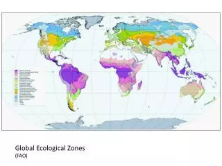
AGRO-ECOLOGICAL ZONES (AEZ)
690 likes | 2.63k Vues
AGRO-ECOLOGICAL ZONES (AEZ). AGRO-ECOLOGICAL ZONES (AEZ).

AGRO-ECOLOGICAL ZONES (AEZ)
E N D
Presentation Transcript
AGRO-ECOLOGICAL ZONES (AEZ)
AGRO-ECOLOGICAL ZONES (AEZ) Istilah 'zona Agro-ekologi', singkatan AEZ, mengacu pada metode apapun untuk membagi permukaan bumi menjadizona-zonayang relatifhomogen sehubungan dengan faktor-faktor fisik yang penting bagi produksitanaman. Istilah inipertama kali dimunculkanolehFAO pertengahan 1970-an untuk menentukan potensi daya dukungmanusia. Ide dasarnyadari zonasiiniadalahmemproduksi penilaian kuantitatif adaptasi tanaman yang umum bagi semua AEZ. Food and Agriculture Organization of the United Nations. 1978. Report on the Agro-ecological zones project. World Soil Resources Report 48, Vol. 1: Methodology and results for Africa. Rome: FAO. xi, 158 pp. Kassam, A.H., van Velthuizen, H.T., Fischer, G.W., and Shah, M.M. 1991. Agroecological land resources assessment for agricultural development planning: A case study of Kenya; Resources database and land productivity. Vol. Main Report. Rome & Vienna: Food and Agriculture Organization of the United Nations (FAO) & International Institute for Applied Systems Analysis (IIASA). xi, 196 pp.
AGRO-ECOLOGICAL ZONES (AEZ) Original reference: (Food and Agriculture Organization of the United Nations, 1978) for Africa, and subsequent volumes for Southeast Asia, Southwest Asia, and Central & South America. The land evaluator can use the 1:20’000.000 (OLD = 160,000 km²) result maps for general ideas of crop suitability, or can use the methodology itself to produce largerscale maps. An example of larger-scale AEZ is (Kassamet al., 1991), which is the first country-level study (Kenya, at 1:1’000.000) following the continental studies. Food and Agriculture Organization of the United Nations. 1978. Report on the Agro-ecological zones project. World Soil Resources Report 48, Vol. 1: Methodology and results for Africa. Rome: FAO. xi, 158 pp. Kassam, A.H., van Velthuizen, H.T., Fischer, G.W., and Shah, M.M. 1991. Agroecological land resources assessment for agricultural development planning: A case study of Kenya; Resources database and land productivity. Vol. Main Report. Rome & Vienna: Food and Agriculture Organization of the United Nations (FAO) & International Institute for Applied Systems Analysis (IIASA). xi, 196 pp.
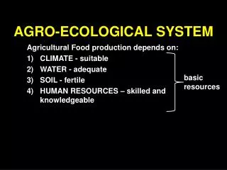
AGRO-ECOLOGICAL ZONES (AEZ) TUJUAN Continental studies: “To obtain a first approximation of the production potential of the world’s land resources, and so provide the physical data base necessary for planning future agricultural development.”. It is explicitly aimed at potential production of human energy crops (rice, maize, sorghum, pearl millet, wheat, soybean, phaseolus bean, cassava, white potato, sweet potato) as well as cotton, given the physical resource base, especially climate and to a lesser extent soils, not taking into account social and economic factors. The geopolitical questions are: what is the human carrying capacity in each political division? and what are the implications for migration pressure? Sumber:
AGRO-ECOLOGICAL ZONES (AEZ) TUJUAN Country-scale studies are intended to zone rural development policies (credit, infrastructure, research). These try to answer more specific questions, e.g. “Where can maximum returns from increased inputs be obtained and on what land uses?”, “What levels of investment are needed to obtain these returns?”, “Where should research, extension, and education efforts be concentrated?” Already we see that AEZ grades into economic land evaluation when it is applied at a larger scale. Sumber:
Agroecological principles and practices. Sumber: http://ilri.org/infoserv/Webpub/fulldocs/Critical/opportun.htm
PRINCIPLES AND PRACTICES FOR SUSTAINABLE AGRICULTURE a. Agrobiodiversity conservation and enhancement Conservation of diversity of crop and livestock varieties and diverse agroecosystems, mainly through in situ conservation, support of mixed/multiple cropping systems, and use of integrated crop/pest/soil management methods and agroforestry; Revitalization of useful indigenous landraces and knowledge on diversity in agroecosystems Development of community-based seed banks, community involvement and leadership in research on agrobiodiversity, and benefit-sharing schemes for genetic resources. Many studies and experiences in the Greater Horn have shown great benefits from the conservation and enhancement of plant genetic resources Sumber: http://ilri.org/infoserv/Webpub/fulldocs/Critical/opportun.htm
PRINCIPLES AND PRACTICES FOR SUSTAINABLE AGRICULTURE b. Soil conservation/fertility management, particularly bio-intensive and regenerative methods for nutrient management—including cover crops, minimum tillage, mulches, manures, intercropping, and terracing. Soil conservation measures have been proven to increase yields some 20 to 40 percent in countries of the Greater Horn (Hutchinson et al 1991; Cleaver and Schreiber 1994; Reardon and Shaikh 1995). c. Integrated pest and nutrient management methods that are ecologically oriented and farmer-driven, and well-adapted to local needs and conditions (Thrupp 1996). d. Agroforestry development, stressing the integration of indigenous trees into farming systems, and development of community tree nurseries, with involvement of local people. Sumber: http://ilri.org/infoserv/Webpub/fulldocs/Critical/opportun.htm
PRINCIPLES AND PRACTICES FOR SUSTAINABLE AGRICULTURE Sustainable pasture, livestock and fisheries management, building on pastoralists' traditional, sustainable livestock management practices. f. Water conservation and water management methods (including small-scale irrigation systems) to help reduce risks of droughts and stabilize supplies. Sumber: http://ilri.org/infoserv/Webpub/fulldocs/Critical/opportun.htm
AGRO-ECOLOGICAL ZONES (AEZ) Outputs of the continent-scale studies A global, quantitative climatic classification for rainfed agriculture, for each of the chosen crops. An agro-climatic adaptability classification (for each crop), in a form suitable for matching crops with climate and soil resources Crop production cost data by soil and climatic zone, sufficient to judge whether yields exceed costs. For each crop, a map of suitability classes S1, S2, S3/N1 and N2, based on predicted relative biomass production (>80%, 40-80%, 20-40%, <20% of the constraint-free yield), for two technology levels (high and low inputs) which define a general Land Utilization Type. Sumber:
AGRO-ECOLOGICAL ZONES (AEZ) Climatic requirements of crops These include moisture (from rainfall and soil storage), temperature, radiation, and photoperiod, as they affect growth and phenology. This data is synthesized into interpretive climatic maps: (1) length of growing period; (2) pattern of growing period; (3) thermal zone. The crops are grouped according to their photosynthetic pathway (C3, C4, C4 adapted for highlands) as this greatly affects how the plant responds to moisture and temperature. The key innovation is the length of growing period, which in the tropics is based on rainfall patterns and in the subtropics also on temperature. This is used to quantify yield reductions. Sumber:
AGRO-ECOLOGICAL ZONES (AEZ) Soil requirements of crops These include internal requirements (e.g., soil temperature, moisture, aeration, fertility, depth, stoniness, salinity and other toxicities) and external or site requirements (e.g., slope, micro- and macro-relief, occurrence of flooding during the growing period, accessibility and trafficability). In these studies, major land improvements (irrigation, drainage, leaching, land shaping etc.) are not contemplated. So these are really soil and landscape requirements. For each of these, a table is established with optimum and extreme values. For example, salinity for soybean: optimum is 0 to 4 dS m-1, extreme values are 0 to 6. The optimum level is associated with yields from 80-100% yield. Sumber:
S.A.L.T. system of soil conservation for hill, land. Large blocks of leucaena aren't recommended for steep, unstable slopes, unless they pruned regularly to allow sunlight to reach the soil so that undergrowth will develop. Sumber: http://www.nzdl.org/gsdlmod?e=d-00000-00---off-0hdl--00-0----0-10-0---0---0direct-10---4-------0-1l--11-en-50---20-help---00-0-1-00-0-0-11-1-0utfZz-8-00&cl=CL3.43&d=HASH412cd503b5262205ac14c6>=2
SALT ((Sloping Agricultural Land Technology). It was developed by the Mindanao Baptist Rural Life Center in Davao del Sur, Philippines in 1979 and has become increasingly popular in that country since then. Although it can be effective on very steep slopes, it's best suited to regions with a long rainy season which allows the growing of soil-stabilizing perennial crops like cacso, banana, and pineapple without irrigation. It incorporates the use of a leguminous tree/shrub called leucaena or ipil-ipil (Leucaenaleucocephala), although other perennial legumes could be subsituted. Sumber: http://www.nzdl.org/gsdlmod?e=d-00000-00---off-0hdl--00-0----0-10-0---0---0direct-10---4-------0-1l--11-en-50---20-help---00-0-1-00-0-0-11-1-0utfZz-8-00&cl=CL3.43&d=HASH412cd503b5262205ac14c6>=2
SALT ((Sloping Agricultural Land Technology). The main features and practices of S.A.L.T: Contour lines are laid out across the slope at intervals of 4-6 meters, depending on steepness and soil conditions. A one meter-wide strip along each contour line is plowed up following the marker stakes. Two planting rows 50 cm apart are prepared, and leucaena seeds are sown 2-5 cm apart. Though slow-growing at first, the leucaena will form a thick, erosion-resistant hedgerow in 4-6 months and may reach 5-6 meters in a year. Aside from erosion protection, its leaves are used for mulching and fertilizer (being a legume, they're high in N), and the plants provide firewood, poles, and animal feed (leaves and pods). Sumber: http://www.nzdl.org/gsdlmod?e=d-00000-00---off-0hdl--00-0----0-10-0---0---0direct-10---4-------0-1l--11-en-50---20-help---00-0-1-00-0-0-11-1-0utfZz-8-00&cl=CL3.43&d=HASH412cd503b5262205ac14c6>=2
SALT ((Sloping Agricultural Land Technology). The main features and practices of S.A.L.T: 3. While the leucaena is becoming established, the land is best left in its natural vegetation instead of being plowed. However, tree crops like citrus and banana can be planted and weeded by working only the immediate area around the plant, thus not inviting erosion. 4. Once the leucaena is established, other strips between these perennial crops can be plowed and planted to more erosion susceptible annuals like maize and vegetables. Sumber: http://www.nzdl.org/gsdlmod?e=d-00000-00---off-0hdl--00-0----0-10-0---0---0direct-10---4-------0-1l--11-en-50---20-help---00-0-1-00-0-0-11-1-0utfZz-8-00&cl=CL3.43&d=HASH412cd503b5262205ac14c6>=2
SALT (Sloping Agricultural Land Technology). The main features and practices of S.A.L.T: 5. The leucaena is cut once a month down to 1 meter height and the leaves are placed around the base of the crops for fertilizer and mulch. 6. Natural terrace formation: Barriers are formed by piling rocks, stalks, leaves, and branches at the base of the leucaena rows. Over the years, any soil carried downslope will collect at the barriers, and a natural terracing will take place. Sumber: http://www.nzdl.org/gsdlmod?e=d-00000-00---off-0hdl--00-0----0-10-0---0---0direct-10---4-------0-1l--11-en-50---20-help---00-0-1-00-0-0-11-1-0utfZz-8-00&cl=CL3.43&d=HASH412cd503b5262205ac14c6>=2
AGRO-ECOLOGICAL ZONES (AEZ) Soil resource inventory The FAO Soil Map of the World at 1:5’000,000 was used as the soils map. It is recognized that this document is of very uneven quality; the map itself shows three degrees of reliability. The soil properties necessary for the evaluation are inferred from the map unit name, which in turn implies certain diagnostic horizons, and the map unit phase, for slope and texture. The scale and level of detail of this map is well-matched with the objectives of the study. In a country study, a more detailed soil map (e.g. 1:1’000.000 or 1:500.000) is needed. Sumber:
AGRO-ECOLOGICAL ZONES (AEZ) Soil resource inventory Note that a general soil map can list several components for each map unit; although these can not be shown on the map due to scale constraints, each can be described and interpreted separately, and the proportion of the map unit covered by the component can be listed. Thus accurate computations of suitable areas are possible even with small-scale maps. Sumber:
AGRO-ECOLOGICAL ZONES (AEZ) Relation to FAO-style land evaluation The original study is not a detailed land evaluation because the LUTs are crudely defined; the country studies have more detail. The AEZ can be interpreted for many of the ‘agroecological’ LURs in a land evaluation, e.g. growing period, radiation regime, harvest conditions. The FAO’s AEZ uses the Framework for Land Evaluation definitions of suitability based on relative yield, and also adopts the basic principles of the Framework as a starting point. The country studies explicitly follow the Framework. In a sense, any land evaluation for agricultural crops must include an AEZ, even if this is not explicitly stated. Sumber:
Growing Periode Dalampertanian,musim tanam adalah periode setiap tahun ketika tanamanpertaniandapatditanamdantumbuhdenganbaik. Musim tanam biasanya ditentukan oleh iklim dan elevasi, dan pemilihan jenistanamannya. Faktor-faktorlokasi, suhu, siang hari (penyinaran), dan curah hujan, semuanyadapatmenjadifaktor lingkungan yang kritis. Sumber: http://en.wikipedia.org/wiki/Growing_season
Length of Growing Season Panjang musim tanam di wilayah tertentu mengacu pada jumlah hari pada saat pertumbuhan tanaman berlangsung. Musim tanam sering menentukan tanaman dapat tumbuh di daerah, karena beberapa tanaman memerlukan musim tumbuh yang panjang, sementara yang lain cepatmenjadidewasa (masak). Panjang musim tanam dibatasi oleh berbagai faktor. Tergantung pada daerah dan iklim, musim tanam dipengaruhi oleh suhu udara, hujan, danradiasimatahariu (panjanghari). Sumber: www.epa.gov/climatechange/indicators
Length of Growing Season Panjangnya"musim tanam" atau "masa pertumbuhan" (LGS atau LGP), seperti yang didefinisikan oleh Agro-Ekologi proyek Zones (FAO, 1978) :.. Priode (dalam hari) selama setahun ketika curah hujan melebihi setengah evapotranspirasi potensial. Suatuperiode yang diperlukan untuk evapotranspirasi 100mm air hujan yang disimpan dalam profil tanah. Tidak ada ketentuan untuk kelembaban tanah yang tersimpan. Sumber: http://www.fao.org/nr/climpag/cropfor/lgp_en.asp
Length of Growing Season (LGS) LGS bergunadalammenentukanpanjangsiklustanamandankalenderpadakondisirata-rata. Perhitunganmasapertumbuhandidasarkanpada model neraca air sederhana, membandingkanketersediaan air dengankebutuhan air tanaman (curahhujandengan PET), menggunakannilaibulanan. PET (atau ETP) adalahPotensialEvapotranspirasi, yaituukurankekuatanatmosfiruntukmenguapkan air. Periodetumbuh "normal“ (jugadisebutmusimTipe 3) ditandaidenganperiodekering, periodelembab (jugadisebutperiodemenengah) danperiodebasah. Sumber: http://www.fao.org/nr/climpag/cropfor/lgp_en.asp
Length of Growing Season Sumber: http://www.fao.org/nr/climpag/cropfor/lgp_en.asp
Length of Growing Season The Normal Season (Figure 1) has the following characteristics: The Beginning PeriodThe beginning of the growing period occurs when precipitation (PPTN) equals half PET and marks the start to the normal rainy season, shown as a in fig. 1. A value of one half PET has been chosen as germinating crops do not evapotranspire at the full rate of PET and false starts to the rainy season are eliminated. The beginning marks the transition from the dry period to the "intermediate" period when PET/2 < R < PET. The wet (humid) PeriodThis is the period during which precipitation exceeds PET. The beginning and ending dates (shown as b and c in fig. 1, respectively) are the two points where the precipitation and PET curves cross. The End to the Growing PeriodThe end of the growing period occurs at the point where the precipitation curve crosses the one half PET curve (labeled as d in fig. 1). Sumber: http://www.fao.org/nr/climpag/cropfor/lgp_en.asp
Length of Growing Season The additional season types are as follows: All Year Round Dry Period (Type 1)The average monthly precipitation for every month of the year is lower than half the average monthly PET. Areas with all year round dry periods have been inventoried separately as areas with a growing period of 0 days. Intermediate-Dry Growing Period (Type 2)Throughout the year, the average monthly precipitation does not exceed the full rate of the average monthly PET, but it does exceed half the PET. The beginning and the end of such an intermediate growing period are defined as the points where the precipitation curve crosses the one half PET curve and no humid period exists. Sumber: http://www.fao.org/nr/climpag/cropfor/lgp_en.asp
Length of Growing Season The additional season types are as follows: 3. All Year Round Intermediate Growing Period (Type 4)During the entire year, the rainfall stays permanently between PET and one half PET. This is a very rare type of season with no beginning or end. 4. All Year Round Humid Growing Period (Type 5)In this kind of season, the average monthly precipitation during every month of the year exceeds the full rate of the average monthly PET. Thus, there is no true start to the growing period or to the humid period. Areas with all year round humid growing periods are inventoried as areas with a normal growing period of 365 days. 5. Intermediate-Humid Growing Period (Type 6)This type of season has both an intermediate and a humid period but no dry period (i.e., a period in which the precipitation curve drops below one half PET). Sumber: http://www.fao.org/nr/climpag/cropfor/lgp_en.asp
RADIATION REGIME Solar irradiance (Radiasimatahari) adalah ukuran dari radiasi (daya per satuan luas di permukaan bumi) yang diproduksi oleh mataharidalam bentuk radiasi elektromagnetik, yang dianggap oleh manusia sebagai sinar matahari. Solar irradiance pada area spesifik dapat diukur sebagai insolation, energi radiasi matahari per satuan luas selama waktu tertentu, atau sebagai insolation langsung, insolation yang mencapai lokasi di Bumi setelah penyerapan dan hamburan di atmosfer. Jumlah radiasi matahari (TSI), adalah ukuran dari jumlah insiden energi radiasi matahari pada keseluruhan atmosfer bumi. Ini merupakan sebagian kecil dari konstanta Solar, jumlah total radiasi elektromagnetik yang berasal dari Matahari ke segala arah. Sumber: http://en.wikipedia.org/wiki/Solar_irradiance
PANJANG HARI Panjang hari, atau panjang siang hari, adalah waktu setiap hari dari saat ekstremitas atas dari disk matahari muncul di atas cakrawala saat matahari terbit sampai saat ketika ekstremitas atas menghilang di bawah cakrawala saat matahari terbenam. Karena difusi dan pembiasan sinar matahari oleh atmosfer, sebenarnya ada daylight bahkan ketika matahari berada sedikit di bawah cakrawala. Periode ketika masih agak terangmeskipun matahari berada di bawah cakrawala disebut “senja”. Sumber: http://en.wikipedia.org/wiki/Day_length
PANJANG HARI Secara umum, panjang hari bervariasi sepanjang tahun, dan tergantung pada garis lintang. Variasi ini disebabkan oleh kemiringan sumbu rotasi bumi terhadap bidang ekliptika bumi mengelilingi matahari. Pada titik balik matahari yang terjadi sekitar bulan Juni 20-22, kutub utara dimiringkan ke arah matahari, dan karena belahan bumi utara telah mulai hari dalam durasi dari lebih dari 12 jam di bagian selatan Tropic of Cancer sampai 24 jam di Antartika , sedangkan belahan bumi selatan memiliki hari mulai durasi dari hanya di bawah 12 jam di bagian utara Tropic of Capricorn nol di Lingkaran Antartika. Sumber: http://en.wikipedia.org/wiki/Day_length
PANJANG HARI Beberapafaktamenarikadalahsebagaiberikut: Di Khatulistiwa, durasisiangharitidakpersis 12 jam sepanjangtahun, melainkan(karenapembiasanatmosferdanukuranMatahari) melebihi 12 jam dengansekitar 7 menitsetiaphari; Karenamataharidiutarakhatulistiwaselamahampir 4 harilebihdarisetengahtahun, karenaeksentrisitas orbit bumi, durasi rata-rata haripadalintangtertentudibelahanbumiutaramelebihidurasihari rata-rata padasaat yang samalintangdibelahanbumiselatanolehbeberapamenit; Selamabeberapaharidiekuinoks-tentang 19-22 Maretdan 21 September-24-kedua kutubmengalamisimultan 24 jam sianghari, terutamakarenapembiasanatmosfer. Setiapkutupmemilikihanyasatumatahariterbitdanmatahariterbenamsatu per tahun, sekitarwaktuekuinoks. Sunrise Setiapkutubinihampirbertepatandenganmatahariterbenam yang lain, dengansedikitperbedaanakibatpembiasanatmosfer. Sumber: http://en.wikipedia.org/wiki/Solar_irradiance
…. Sumber: http://en.wikipedia.org/wiki/Solar_irradiance