Download
1 / 10
100 likes | 119 Vues
A major magnitude 7.0 earthquake hit Andreanof Islands, Aleutian Islands, Alaska. No tsunami warnings were issued, affecting nearby Adak Island. Learn about the seismic activity and historical data.

E N D
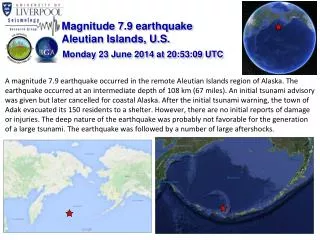
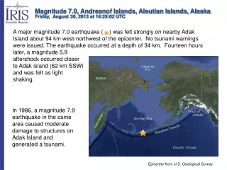
Magnitude 7.0, Andreanof Islands, Aleutian Islands, Alaska Friday, August 30, 2013 at 16:25:02 UTC A major magnitude 7.0 earthquake ( ) was felt strongly on nearby Adak Island about 94 km west-northwest of the epicenter. No tsunami warnings were issued. The earthquake occurred at a depth of 34 km. Fourteen hours later, a magnitude 5.9 aftershock occurred closer to Adak island (62 km SSW) and was felt as light shaking. In 1986, a magnitude 7.9 earthquake in the same area caused moderate damage to structures on Adak Island and generated a tsunami. Epicenter from U.S. Geological Survey
Magnitude 7.0, Andreanof Islands, Aleutian Islands, Alaska Friday, August 30, 2013 at 16:25:02 UTC USGS PAGER Population Exposed to Earthquake Shaking The USGS PAGER map shows the population exposed to different Modified Mercalli Intensity (MMI) levels. According to news reports, it was strongly felt in Atka, an Aleut community of 64 people, and the larger Aleutian town of Adak, where 320 people live. Adak Is. The color coded contour lines outline regions of MMI intensity. The total population exposure to a given MMI value is obtained by summing the population between the contour lines. The estimated population exposure to each MMI Intensity is shown in the table below.. Image courtesy of the US Geological Survey
Magnitude 7.0, Andreanof Islands, Aleutian Islands, Alaska Friday, August 30, 2013 at 16:25:02 UTC Earthquake and Historic Seismicity The 34-km-deep hypocenter for this earthquake ( ) is plotted on a map of regional seismicity greater than M 5 since 1990. Two dozen M 6.5 or larger earthquakes have occurred within 250 km of this earthquake over the last century. On average, Alaska experiences one M 7 earthquake per year. Text, epicenters, and rupture zones from U.S. Geological Survey
Magnitude 7.0, Andreanof Islands, Aleutian Islands, Alaska Friday, August 30, 2013 at 16:25:02 UTC Earthquake and Historic Seismicity In 1986, a magnitude 7.9 earthquake in the same area caused moderate damage to structures on Adak Island and caused a small tsunami recorded throughout the Pacific Ocean. The estimated 1986 rupture margin is indicated by dashed red line (– – –). The tan areas show rupture zones of historic earthquakes labeled with dates and magnitudes of those events Text, epicenters, and rupture zones from U.S. Geological Survey 2013
Magnitude 7.0, Andreanof Islands, Aleutian Islands, Alaska Friday, August 30, 2013 at 16:25:02 UTC This earthquake occurred as the result of thrust faulting on or near the subduction zone interface between the Pacific and North America plates. The depth and mechanism of this earthquake are consistent with it occurring along the megathrust interface between these two plates. W N S Asterisks indicate earthquake locations. Earthquakes occur within the brittle plates due to deformation. Megathrust earthquakes occur on the interface between the plates when force overcomes friction. (Only major plates shown.)
Magnitude 7.0, Andreanof Islands, Aleutian Islands, Alaska Friday, August 30, 2013 at 16:25:02 UTC Rate and direction of motion of the Pacific Plate with respect to the North American Plate. http://jules.unavco.org/Voyager]r/Earth Note change in the direction of the relative motion of the plates, from nearly perpendicular to the plate boundary on the eastern end of the Aleutian trench to nearly parallel at the western end.
Magnitude 7.0, Andreanof Islands, Aleutian Islands, Alaska Friday, August 30, 2013 at 16:25:02 UTC The record of the earthquake on the University of Portland seismometer (UPOR) is illustrated below. Portland is 3836 km (2382 miles, 34.56°) from the location of this earthquake. Following the earthquake, it took 6 minutes and 46 seconds for the compressional P waves to travel a curved path through the mantle from the earthquake to Portland, Oregon. S waves are shear waves that follow the same path through the mantle as P waves. S waves took 12 minutes and 14 seconds to travel from the earthquake to Portland. Surface waves, both Love and Rayleigh, traveled the 3836 km (2382 miles) along the perimeter of the Earth from the earthquake to the recording station. The travel time for surface waves was about 17 minutes.
Magnitude 7.0, Andreanof Islands, Aleutian Islands, Alaska Friday, August 30, 2013 at 16:25:02 UTC USGS Centroid Moment Tensor Solution This earthquake occurred on the boundary between the Pacific and North American tectonic plates as a result of thrust faulting. The Pacific Plate subducts beneath the North America Plate along the Aleutian Trench. Given the regional plate tectonic setting of this earthquake where the interplate megathrust fault dips to the north-northwest, it is expected that the fault plane is the north-northwest dipping nodal plane. Shaded areas show quadrants of the focal sphere in which the P-wave first motions are away from the source, and unshaded areas show quadrants in which the P-wave first motions are toward the source. The dots represent the axis of maximum compressional strain (in black, called the "P-axis") and the axis of maximum extensional strain (in white, called the "T-axis") resulting from the earthquake. Thrust Fault Image courtesy of Richard Harwood, Black Hawk College An introduction to focal mechanisms can be found in the animation at the URL below: http://www.iris.edu/hq/programs/education_and_outreach/animations/25
Magnitude 7.0, Andreanof Islands, Aleutian Islands, Alaska Friday, August 30, 2013 at 16:25:02 UTC Seismic waves crossing the US as recorded by the USArray As earthquake waves reach the surface of the Earth, they cause the ground to move. With the 400 earthquake recording stations in EarthScope’s Transportable Array, the ground motions can be captured and displayed as a movie, using the actual data recorded from the earthquake.http://www.iris.edu/spud/gmv/1559866
Magnitude 7.0, Andreanof Islands, Aleutian Islands, Alaska Friday, August 30, 2013 at 16:25:02 UTC Teachable Moments are a service of IRIS Education & Public Outreach and The University of Portland