Download
1 / 7
70 likes | 85 Vues
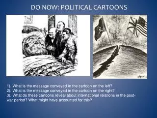
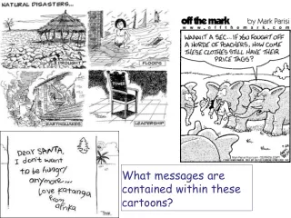
Explore the messages and themes depicted in cartoons from Sub-Saharan Africa, while also learning about the Sahara desert and African geography. Conduct internet research and create fact files on African countries.

E N D
Sub-Saharan Africa Use your atlases to locate the Sahara desert in Africa. Which countries are covered by the Sahara?
Internet Research • http://en.wikipedia.org • Click onto Geography • Find the section that is called “Subportals” and click on Africa. • What % of the world’s total land surface does Africa cover? • How many people live in Africa? • How many countries make up Africa? • What is the longest river in Africa? • What and where is the largest waterfall in Africa?
You design the level descriptors! • You are going to be asked to produce a fact file about an African country. • What do you need to do to get a Level 3, a Level 4, a Level 5 or a Level 6????
Individual research… • Select an African country from the list below and complete a fact file giving as much detail as possible. Use the wikipedia website and other search engines. • Egypt, Sudan, Ethiopia, Kenya, Tanzania, Malawi, Mozambique, Zimbabwe, Botswana, Swaziland, Lesotho, South Africa
My case study about: _________________________________ Population: _________________________ Area of country: ______________________ Flag Map of: Languages spoken: ____________________________________ ____________________________________ Capital city: _________________________________________ Currency: __________________________________________ Wealth (GNP – Gross National Product): ____________________ Major exports: ______________________________________ ______________________________________ Religion: ___________________________________________ Famous people: ______________________________________ ______________________________________ Famous manmade landmarks: ____________________________ _____________________________ Famous natural features: _______________________________ _______________________________ Bordering countries: ___________________________________ ___________________________________
Atlas/Africa Dominoes • You each have a domino with an answer and a question on it. • Use the atlas to help you work out if you have the answer!