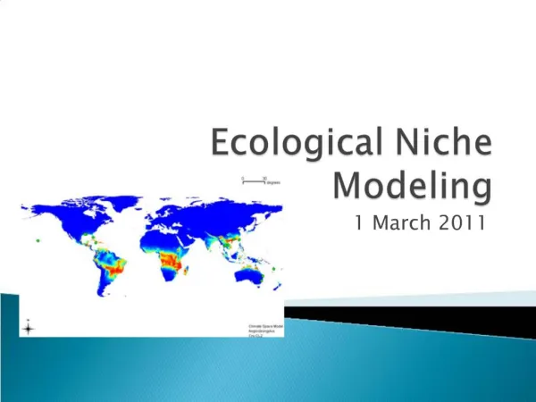
Ecological Observation Modeling Approach
Ecological Observation Modeling Approach. Dennis Ojima Natural Resource Ecology Laboratory. MAY 2006 Tucson, Arizona. Collaborators David Schimel (NCAR), Steve Running (U of MT), Russ Monson (CU), Brit Stevens (NCAR), Jeff Hicke (CSU). Funding from NSF, NASA, NOAA. WHY NOW?.

Ecological Observation Modeling Approach
E N D
Presentation Transcript
Ecological Observation ModelingApproach Dennis Ojima Natural Resource Ecology Laboratory MAY 2006 Tucson, Arizona
CollaboratorsDavid Schimel (NCAR), Steve Running (U of MT), Russ Monson (CU), Brit Stevens (NCAR), Jeff Hicke (CSU) Funding from NSF, NASA, NOAA
WHY NOW? • Grand Challenges facing Environmental Sciences • Land Use; Climate change; Biodiversity; Biogeochemical cycles; Infectious disease; Invasive species • New Observations for Terrestrial Systems • New Cyber Infrastructure Developments • New Advancements in Quantitative Analysis • Development of Data-Model Fusion Techniques
Land Use Change More land was converted to cropland in the 30 years after 1950 than in the 150 years between 1700 & 1850 Cultivated Systems in 2000 cover 25% of Earth’s terrestrial surface (Defined as areas where at least 30% of the landscape is in croplands, shifting cultivation, confined livestock production, or freshwater aquaculture) Millennium Ecosystem Assessment 2005
Temperature Anomalies (2003) Data source: (Jones and Moberg 2003). Processed by the U.S. NOAA NCDC Global Climate at the Glance Mapping System
MODIS Optical Density (Average 2001)
Brown Cloud Nitrogen Nitrogen Nitrogen Dust Storms Global and Regional Telecommunications Fire
CHALLENGES and NEEDSOF Terrestrial Environmental Observations and Analysis • Multiple Stresses • Interactive Sectors • Increasing Human Pressures • Information Exchange to Multiple Publics • Science • Managers • Policy Makers • Public at Large
This is a Time of Great Opportunity • Digital information explodes • Bandwidth increases • Wireless capabilities expand • HPCC and IT technologies advance and pervade science and society • Collaborative, multidisciplinary activities increase • Integrative approaches demanded
Multi-sensor/Multi-scale Modeling Framework Nemani et al., 2003, EOM White & Nemani, 2004, CJRS
Changing How Science is Done • Collect data from digital libraries, laboratories, and observation • Analyze the data with models run on the grid • Visualize and share data over the Web • Publish results in a digital library
National Ecological Observatory Network (NEON) NEON: A continental research platform designed to provide the capacity to forecast future states of ecological systems for the advancement of science and the benefit of society • Novel infrastructure that: • allows scientists to observe the previously unobservable • scale from m2 to continent • evaluate fundamental theory at regional to continental scale • enables a new forecasting and predictive capacity for ecology • takes advantage of new and evolving in situ sensing technologies • couples human and natural systems
? Create high res. products by coupling high res. imagery with field and tower data Multiple use of airborne or high res. satellite data for extrapolation of sites observations Correlate Aggregate Some graphics courtesy of BigFoot project, layout courtesy of Shunlin Liang From points to pixels
Information Technology for Biogeosciences • SCIENCE BASED: Developing and testing theory and models requires integration of complex in situ process data with large gridded data sets. • MULTI-SCALED: Required data are multi-scale, many formats, originating in multiple disciplines. • AGILE: Rapid prototyping and development cycle to maximize user control of information systems, implies incorporating existing state-of-the-art components rather than de novo development • USER-DRIVEN: Data systems must allow user-driven, knowledge-based querying of multiple data types
ACME-CME: (Aircraft) C in the Mountains Experiment Sponsors: NSF-NASA Collaborating Inst: CU-NCAR-CSU-NOAA
ACME-CME • To understand carbon dynamics in montane forest regions by developing new methods for estimating carbon exchange at local to regional scales • “Bottom-Up” (plot and tower obs) and “Top-Down” (aircraft and satellite obs) constraints • Evaluate factors affecting C-exchange in complex terrain as compared to flat landscapes to better understand the significance and contribution of mountain areas to the continental carbon budget.
Integrating Across Scales Through Top-down & Bottom-up Approaches
Erosion and organic matter transport Downslope flows and subsequent venting of CO2 Tower Downwind Profiles Footprint NEE F Wind Wind CH4 Upwind Profiles Soil Chamber VOC CO VOC CO Carbon-containing pollutant transport: 10s-1000s of km CO2 Wildfire source Biogenic source Missoula: Urban source Courtesy of Steve Running, U Montana
Model-data fusion: processes at the scale of biosphere-atmosphere exchange SipNET Niwot Ridge, Colorado
SPACENET Model Structure Photosynthesis (Phenology,Soil Moisture, Tair, VPD, PAR) Plant Respiration (Plant C, Tair) Plant Carbon Precip. Transpiration Litterfall (Plant C, Phenology) Soil Respiration (Soil C, Soil Moisture, Tsoil) Soil Moisture Soil Carbon Drainage
Model vs. Data: Unoptimized & Optimized Parameters Blue: Model Red: Data Dates: 11/1/98 – 10/31/02 Each point represents one half-daily time step Initial guess parameters Optimized parameters
Regional carbon data assimilation system based on RAMS atmosphere model Carbon Data-Model Assimilation (C-DAS) http-Based Interface 4D VAR Assimilation System RAMS Estimated Fluxes DODS Aggregation Server CO2, And Meteorological Observations Observing System GrADS- DODS Server RAMS Adjoint Compare, minimize 1st Guess fluxes From SPACENET CO2 Observations Airborne and surface CO2, obs Optimizer 4D VAR Assimilation System http://dataportal.ucar.edu/CDAS/
Multiple Modeling Approach for Terrestrial C Fluxes • Inverse modeling of atmospheric chemistry • Constrain C sinks; little info on why or exactly where • Biogeochemical models • Test physiological changes; little land use or disturbance • Land-use bookkeeping models • Track land-use change, but no climate or physiology • Flux towers • Integrated site-level measurements, but relatively few sites • Forest inventories
ACME/CDAS Approach • Bring together observationalists and modelers to form an integrated approach to improving our understanding of the global carbon cycle. • Initial effort: Network design exercises based on a selected assimilation modeling strategy. • Ongoing: Further development of the assimilation tool and support for testing and planning/educational use by the community.
Information Technology for Global Environmental Change Sciences • Developing and testing theory and models requires integration of complex in situ process data with large gridded data sets. • Required data are multi-scale, many formats, originating in multiple disciplines. • Rapid prototyping and development cycle to maximize user control of information systems, implies incorporating existing state-of-the-art components rather than de novo development • Data systems must allow user-driven, knowledge-based querying of multiple data types