Download
1 / 1
20 likes | 203 Vues
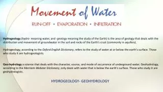
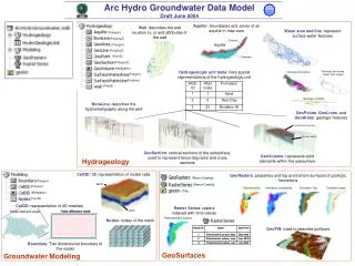
Arc Hydro Groundwater Data Model Draft June 2004. Aquifer : boundaries and zones of an aquifer in map view. Well : describes the well location (x, y) and attributes of the well. Water area and line : represent surface water features. (Polygon). (PolylineZ). (Polygon). (PolylineZ).

E N D
Arc Hydro Groundwater Data Model Draft June 2004 Aquifer: boundaries and zones of an aquifer in map view Well: describes the well location (x, y) and attributes of the well Water area and line: represent surface water features (Polygon) (PolylineZ) (Polygon) (PolylineZ) (PointZ) (PolygonZ) (Multipatch) Hydrogeologic unit table: links spatial representations of the hydrogeologic unit (Polygon) (Polyline) (PointZ) BoreLine: describes the hydrostratigraphy along the well GeoPoints, GeoLines, and GeoAreas: geologic features GeoSection: vertical sections of the subsurface, used to represent fence diagrams and cross sections GeoVolume: represents solid elements within the subsurface Hydrogeology Cell3D: 3D representation of model cells GeoRasters: properties and top and bottom surfaces of geologic formations (Raster Catalog) (Polygon) (Raster Catalog) (Polygon) (TIN) (Multipatch) (PointZ) Cell2D: representation of 2D meshes Raster Series: rasters indexed with time values Nodes: nodes of the mesh GeoTIN: used to describe surfaces Boundary: Two dimensional boundary of the model GeoSurfaces Groundwater Modeling