Download
1 / 111
1.15k likes | 1.39k Vues
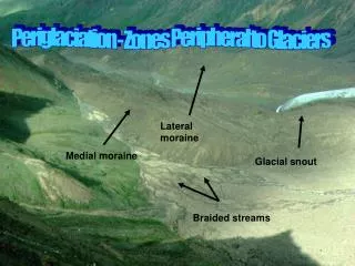
Periglaciation - Zones Peripheral to Glaciers. Lateral moraine. Medial moraine. Glacial snout. Braided streams. Photo 2: = Ice wedges polygons + thermokarst lakes Photo 3: Collapsed Pingo – closed system Photo 4: Patterned Ground – Stone Circles. Some useful links in Periglaciation:

E N D
Periglaciation - Zones Peripheral to Glaciers Lateral moraine Medial moraine Glacial snout Braided streams
Photo 2: • = Ice wedges polygons + thermokarst lakes • Photo 3: • Collapsed Pingo – closed system • Photo 4: • Patterned Ground – Stone Circles
Some useful links in Periglaciation: http://www.fettes.com/Cairngorms/periglacial_Holocene.htm http://www.mapcruzin.com/arctic_refuge/permcycl.html
Where are Peri-glacial Enviornments? • High Latitudes areas - eg Alaska • “Tundra” Regions • High altitude temperate latitudes - eg Alps / Andes • Covers approx. 20% of earth’s land surface • They are the areas found close to (peripheral) glaciers
Permafrost The thermal condition of the soil and rock. Temperatures below 0ºC persist over at least 2 consecutive winters and the intervening summer - I.e the ground is frozen
Permafrost • Covers 20-25% of Earth’s surface - eg: • Siberia • Northern Canada • Alaska • China • Types of Permafrost: • Continuous • Discontinuous • Sporadic (isolated) • Thickness ranges from several metres > 500m (eg Siberia)
Periglacial Processes: 1. Frost Shattering Frost Shattering Frost Heave: a) Frost Pull, b) Frost Push Frost Cracking 2. Weathering Freeze-Thaw Salt-Weathering Carbonation 3. Mass Movements Frost Creep Solifluction – ground NOT frozen Gelifluction – where ground is frozen
Frost Action Processes: • Dominant set of processes in periglacial • environments is freeze-thaw cycles. This operates • Most effectively where the temperature oscillates • around the freezing point. • Frost Wedging • Sometimes called “frost-shattering” • Mechanical (physical processes) caused by the expansion of water in cracks of rock (9%) • Frost Creep • Very slow mass movement – through freezing = heaving upwards perpendicular to the slope and then thawing = clasts sink down vertically due to gravity
Frost Heave • Frost Pull = occurs when a stone adheres to ice within a freezing active layer and is drawn upwards as the ground heaves • Frost Push / Heave = since stones have a lower specific heat capacity, they heat up and cool down faster than the surrounding soil (a bit like continents heat up and cool down quicker than oceans). A descending freezing front will therefore move through a stone more quickly than it will move through the soil on either side. This means that the soil immediately beneath a stone is likely to freeze and expand pushing the stone upwards – more quickly than the surrounding material = leading to sorting • Involves the displacement of soil and rock underground upwards towards the surface • Produces hills – called pingos and mounds called palsas or thufurs as a core of ice heaves towards the surface
All processes work using water. Type is affected by climate and rate by geology. Processes in the hydrosphere Weathering Erosion Mass Movement
Weathering Chemical Biological Physical / Mechanical
Physical Weathering By Freeze-Thaw Action This process usually happens in cold, wet areas. Water enters joints / cracks in rocks and freezes. As water freezes it expands, putting pressure on the joint / crack. The water then thaws as the temperature rises above 0°C, releasing the joint / crack. When the temperature drops again, the water refreezes and so on, eventually the rock breaks off from the pressure.
Frost shattering • Most active where temperature fluctuate around the freezing point • Water expands by 9% on freezing cracking the rocks apart • EG DARTMOOR GRANITE
Salt crystal growth: • Growth of salt crystals – eg sodium carbonate in cracks in rocks – eg saline water gets into cracks or rocks and breaks them down • Common in coastal areas
Carbonation: • CO2 is more soluble at lower temperatures – this can increase the rate of solubility of limestone (CACO3 – calcium carbonate). • So in periglacial areas – if there is limestone rocks – that rate of weathering is often much greater • Also if CO2 can be sucked out the atmosphere it is going to get rid of a greenhouse gas
The importance of FROST ACTION PROCESSES: The dominant set of processes found in periglacial areas is frost action - eg FREEZE-THAW. When water freezes it expands by 9% and can HEAVE the ground - or expand and lift the ground upwards. Because periglacial environments are cold by nature - there is a great deal of frost action occuring there
Periglacial Processes cont. • 4. Nivation • 5. Fluvial • 6. Aeolian (wind) • Periglacial Case Study Examples: • Alaska • Spitsbergen • Northern Canada • Northern Norway / Lapland • Iceland
Solifluction • Definition: Mass movement of soil and regolith affected by alternate freezing and thawing. Characteristic of saturated soils in high latitudes, both within and beyond the permafrost zone. • A number of features of the Cairngorm environment contribute to active solifluction: • frequent freeze-thaw cycles • saturated soils and regolith, after snow melt and heavy rainfall • frost-susceptible materials, with significant contents of silt and clay, at least at depth • extensive regolith across a range of slope angles • Solifluction adds detail to the terrain underfoot. Small-scale, active landforms include lobes and sheets (Sugden, 1971) and turf-banked terraces. The latter reflect also the action of wind in stripping and shaping the vegetation mat and frequently occur in association with deflation surface (Gordon, 1993). Ongoing mass movement is also indicated by 'ploughing boulders' - large blocks that are moving downslope, pushing a rampart ahead of them and leaving a furrow behind. • Much more striking, however, are the large boulder terraces and lobes that give crenulated patterns to many granite slopes on the plateau. These steps terminate in stone banks up to 3 m high. These forms are absent from within the limits of Loch Lomond Readvance glaciers (Sisson, 1979) and so date from this or earlier periods. As delicate features such as tors have survived beneath ice covers, it is possible that the larger solifluction terraces and lobes may be of considerable age.
Wind The Cairngorms experience some of the highest wind speeds of the British Isles. Gusts over 100 mph may occur several times a year and the weather station recorded the highest UK wind speed in a gust of 173 mph in March 1986. Erosion by strong winds creates deflation surfaces. The vegetation, soil and fine material debris is removed to leave an armoured surface where large clasts are embedded within a matrix of grit and sand. Remnants of the former vegetation cover sometimes occur and allow the former thickness of the regolith to be estimated. Grains of sand and fine gravel can be observed in motion during strong winds. The resting places of the transported debris are often unclear but small sand sheets do occur on the northern flank of Ben Macdui. Deflation scars are bare patches that result from opening up of the vegetation. Wind stripes are lines of vegetation that alternate with bare ground (Bayfield, 1984). Wind crescents are arcuate patches of vegetated ground.
Ice patches on the snow result in localised weathering and erosion by freeze thaw. This can lead to small depressions. Saturated material may also slump under gravity - forming a pro talus rampart. Nivation
Snow forms ice curtains which are prone to avalanches Nivation > Avalanches
The wet, deep snow on steep valley sides in the summer can hit the valley floor with such force that large areas can be excavated leaving a deep plunge pool Nivation > Avalanche Plunge Pools
Fluvial Processes > bank erosion of frozen sediments Frozen sediments can be removed by riverbank erosion (abrasion, hydraulic action)
Fluvial • Frozen sediments are powerful erosive tools. • Sandhurs show enormous changes in discharge throughout the year – obviously a higher rate in summer and spring • Much of the year the ground is frozen so there is little runoff – however in summer when there is more melting there will be more fluvial erosion
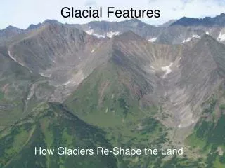
Periglacial Landforms
Periglacial Landforms: BlockfieldsScree / Talus Rock GlaciersGelifluction Lobes/benches Solifluction lobesNivation Hollows Asymmetric ValleysPro talus rampart Flattened Summits Soil (stone) stripes Pingos Thermokarst (Lakes) Loess Sandhurs Dry Valleys Coombe Rock Tors Ice Wedge Polygons Palsas (frost push on peat) Involutions Patterned Ground > 5 types 1.Circles 2.Nets 3.Polygons 4. Steps 5. Stripes Earth Hummocks (no sorting)
Protalus Rampart Definition: Unsorted, non-stratified, coarse angular rock debris forming arcuate low ridges. Associated with former persistent snowbanks in shaded sites, commonly at base of corrie headwalls. 'Protalus rampart' is an overblown title for a simple landform. It requires the existence of long-lived snow banks below rock cliffs. Frost weathering leads to rockfall from the cliff and the blocks roll down the snow slope to accumulate at its base. Ballantyne and Kirkbride (1986) describe good examples from below the Devil's Point and Sròn na Lairige.
These snow patches accelerate freeze thaw (although some studies claim they prevent it!). Under the correct conditions they can develop into full scale glacier cirques. Nivation hollows
NIVATION HOLLOW PROTALUS RAMPART
INVOLUTIONS As water freezes it expands by 9% - repeated freezing and thawing of the active layer causes expansion and contraction of the surrounding material beneath the soil. The resultant breaking, churning, and mixing of the soil, rock and sediment is known as CRYOBURBATION. This can alter beds of sediment that were originally laid down horizontally by twisting and contorting them into folded formations called INVOLUTIONS.
Tors Thought to have been exposed by gelifluction removing the surface regolith and subsequently weathered by freeze thaw Note the surrounding felsenmeer
Blockfields Coarse angular blocks on high summits are a typical consequence of freeze thaw weathering
Scree A common feature of periglacial landscapes although not unique to them
Rock Glacier • Where a large quantity of frost-shattered rock becomes mixed with ice, a rock glacier is formed. This can occur either by: • A large supply of rock debris being added to a small and thin glacier = ice cored rock glacier. • The growth of ice within a large accumulation of rock fragments = ice-cemented rock glacier. • They tend to have a steep front, sometimes as much as 100m in height, and they can reach a length of 1km or more. The presence of ice between rock fragments allows the rock glacier to deform under its weight and move downslope at rates of up to 1m per year.
Definition: a glacier whose motion and behaviour is characterized by a large amount of embedded or overlying rock material A rock glacier may be composed of:1. Ice-cemented rock formed in talus that is subject to permafrost.2. Ice-cemented rock debris formed from avalanching snow and rock.3. Rock debris that has a core of ice; either a debris-covered glacier or a remnant end moraine.
These are a consequence of intermittent freezing of interstitial water allowing the erosion by surface water flow. This process is further increased by gelifluction on the valley sides during periods of partial melting. How have they formed? Dry valleys
Gelifluction benches The melting of segregated and interstitial ice within the soil above the permafrost table results in an excess of moisture. This adds weight, lubricates the particles and moves the material down-slope. Resistance at the front of the mass causes the characteristic lobe to form. These are typically found on gentler slopes with their long axis parallel to the slope contour