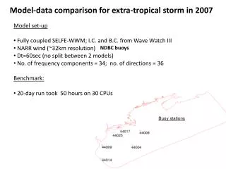
Regional Model-Data Comparison: Synthesis of NACP Interim Results on Carbon Fluxes
This project focuses on the synthesis of interim results from the North American Carbon Program (NACP) regarding carbon fluxes using regional model-data comparisons. It explores various ecosystem models, evaluation of model strengths and weaknesses, and the impacts of interannual variations during 2000-2005, particularly in relation to the 2002 drought. This work helps enhance the understanding of carbon sources, sinks, and their distribution across North America, utilizing diverse data sets and methodologies to refine carbon cycle assessments at different spatial and temporal resolutions.

Regional Model-Data Comparison: Synthesis of NACP Interim Results on Carbon Fluxes
E N D
Presentation Transcript
Regional Model-Data Comparison An NACP Interim Synthesis Project Andy Jacobson, Mac Post, Debbie Huntzinger, Bob Cook Coordinators
Synthesis of Interim NACP Results Ecosystem Models • Contribute in hand regional, continental results (including ones cut from global analyses) • A range of temporal and spatial resolutions • No standardization of model runs! Inversion Models • Contribute North America results in hand from TRANSCOM or from other relevant activities • Spatial scales • TRANSCOM regions, and • 1º grids centered on half-degrees • Temporal scale - monthly
Regional MDC Objectives • Development of benchmark data sets and approaches for model-data evaluation. • Evaluation of strengths and weaknesses of various model formulations, both inverse models and ecosystem models resulting from the comparison to data. • Formal comparison of inverse and forward ecosystem model results for enhancing identification and diagnosis of temporal and spatial patterns of carbon fluxes.
Regional MDC Questions • Interannual Variation • What is the spatial pattern and magnitude of interannual variation in carbon fluxes during 2000-2005? • What are the components of carbon fluxes and pools that contribute to this variation? • 2002 Drought • Do model results and observations show consistent spatial patterns in response to the 2002 drought? • From measurements and ecosystem models, can we infer what processes were affected by the 2002 drought? • Identification of Sources/Sinks • What are the magnitudes and spatial distribution of carbon sources and sinks, and their uncertainties during 2000-2005?
Conversion to Common Grid - both Data and Model • Spatial Resolution: 1°x1°, centered at (x.5, y.5 for each grid cell) • Domain: 50° to 170° W longitude, 10° to 84° N latitude • Temporal Resolution: monthly (or annual) • netCDF files, CF-1 convention
Observations and Measurements • Satellite based • In Hand: • MODIS GPP • MODIS NPP (annual) • In Development • LAI (gap filled, smoothed – MODIS for NACP) • Survey • In Hand: • NASS crop yield based annual NPP • FIA based biomass • In Development: • Soil C (CONUS-SOIL, http://www.soilinfo.psu.edu/), 30cm, 100cm • Site based • Eddy flux NEE, estimated GPP, NPP All of these are not strictly direct measurements
FIA Based Forest Biomass From Deborah N. Huntzinger (University of Michigan) From Blackard et al. (2008), G. Moisen, contact (Rocky Mt. Res. Sta., USFS) Example Regional Data Sets for Model Data Comparison
Spatial Aggregation of Forest Biomass • 250m resolution aggregated to 1 degree • Average biomass of forest on forested land computed • Area of forested land in 1 degree cell kept
Additional Inversion Models • Transcom3 IAV inversion (D Baker),13 models • Rödenbeck Jena, 3 different networks • CarbonTracker • FRCGC Japan (Patra) • U Michigan geostat, 2 models • LSCE France (Peylin) • LSCE France (Chevallier) • LSCE France (Rayner) • Penn State (Butler), 2 models
Forward Model Metadata Report http://daac.ornl.gov/SURVEY8/survey_results.shtml
Analysis Approaches Comparison Techniques: • Time series plots for entire domain, vegetation regions • Statistical point by point comparisons (Taylor plots, cumulative frequency distributions, Index-of-agreement, etc.) • Spatial pattern comparisons (difference plots, variograms, etc.) Combinations of Comparisons: • Forward/Ecosystem model - Data inter-comparison • Inverse and Forward model inter-comparison
Spatial Aggregation - North America Convention: (-) sink (+) source
Taylor Diagrams RMSD2=sd_obs2+sd_mod2-2*sd_obs*sd_mod*R
Spatial Analysis • Used to describe spatial correlation 1 2 3 4 Optimized Anna Michalak University of Michigan
Seasonal Fluctuation of Spatial Variability Deborah Huntzinger University of Michigan
Seasonal Fluctuation of Spatial Variability Semivariance, 2 [moles/m2/sec]2 Correlation Range, 3L (km) Deborah N. Huntzinger University of Michigan Optimized using Ordinary Least Squares
Seasonal Fluctuation of Spatial Variability • where: • Vmax chosen to be: • 0.01 (mols/m2/sec)2 • L and 2 from previous slide Deborah Huntzinger University of Michigan
Preliminary Observations • Data are not strictly observations but involve results of some model • Different data and different methods of comparison reveal various components of model and data compatability • Inverse – forward model comparison allows evaluation of inverse models indirectly with data
Proceeding from Here Need ideas for • Additional regional/continental datasets • Methods for model-data comparison the application of these methods • List of graphics and analysis for working with at ORNL Workshop, January 7-9 • Outline of presentation for NACP Investigator Meeting, February 17-20