Reference Frame in Practice Workshop 1A
Reference Frame in Practice Workshop 1A. Status of Geodetic Infrastructure in Fiji Islands. Mr. Asakaia Tabua. FIG Commission 5 Position and Measurement United Nations Global Geospatial Information Management – Asia Pacific. INTRODUCTION. Fiji Islands Geodetic Framework


Reference Frame in Practice Workshop 1A
E N D
Presentation Transcript
Reference Frame in PracticeWorkshop 1A Status of Geodetic Infrastructure in Fiji Islands Mr. Asakaia Tabua FIG Commission 5 Position and Measurement United Nations Global Geospatial Information Management – Asia Pacific
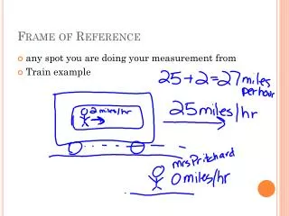
INTRODUCTION Fiji Islands Geodetic Framework • Horizontal Control:- Fiji Map Grid 1986 (WGS72) • Vertical Control:- Mean Sea Level • Fiji is located 17 South and 178 45’ East FIG Commission 5 Position and Measurement United Nations Global Geospatial Information Management – Asia Pacific
Fiji Islands Map Projection Hemisphere South Central Scale Factor 0.9998540 Central Meridian 178 45’ East Zone Width 6 degrees False Latitude 17 South False Easting 2 000 000.00 False Northing 4 000 000.00 Spheroid World Geodetic System 1972 FIG Commission 5 Position and Measurement United Nations Global Geospatial Information Management – Asia Pacific
FIJI GEODETIC DATUM 1986 - WGS72 • In 1979, Royal Australia Survey Corps carried out a Doppler survey of the Fiji group where 18 stations were established, 10 on existing primary stations. • The establishment of Doppler on these stations enabled the whole network to be adjusted on an internationally accepted datum then FIJI GEODETIC DATUM 1986. • Based on reference ellipsoidal - WGS 72 and Projection base on Transverse Mercator FIG Commission 5 Position and Measurement United Nations Global Geospatial Information Management – Asia Pacific
THE DEFINITION AND ADJUSTMENT OF THE FIJI GEODETIC DATUM -1986 J. Hannah and J. Maseyk Department of Survey and Land Information, Wellington, New Zealand FIG Commission 5 Position and Measurement United Nations Global Geospatial Information Management – Asia Pacific
THE DEFINITION AND ADJUSTMENT OF THE FIJI GEODETIC DATUM -1986 J. Hannah and J. Maseyk Department of Survey and Land Information, Wellington, New Zealand FIG Commission 5 Position and Measurement United Nations Global Geospatial Information Management – Asia Pacific
The Current Height Datum of Fiji • In September 1908, then Secretary of State of the Colony of Fiji issued a technical instruction regarding execution of a principal triangulation covering Viti Levu. • Sections 5 & 6 of the technical instruction included specifications for a proposed height datum as follows: • …..5. The heights of the stations should be determined trigonometrically by means of reciprocal vertical angles. • …..6. The heights are to be based on Mean Sea Level, which should be determined "(McCaw GT, 1916). • In order to determine mean sea level, a simple form of tide gauge was placed at Naitonitoni jetty in October 1908, records being kept for a month. • A similar tide gauge was placed at Lautoka Jetty from May 24'h to June 180', 19 10. During the Trigonometrical Survey of Vanua Levu and Taveuni, a simple tide gauge was placed at Malau Jetty near Labasa. • The Mean Sea Level determined from these tide gauges were transferred to the Navua, Lautoka and Labasa base respectively, using a Cook 14" reversible level (McCaw, 1916). Heights of other survey beacons were determined using trigonometric reciprocal heighting. FIG Commission 5 Position and Measurement United Nations Global Geospatial Information Management – Asia Pacific
Thus the Mean Sea Level datum of Fiji was established and to this day it serves as the vertical datum for the country's mapping and surveying applications where there are Two tide Gauges as part of the Pacific Sea Level Monitoring Project. FIG Commission 5 Position and Measurement United Nations Global Geospatial Information Management – Asia Pacific
PROPOSED WAY FORWARD FIG Commission 5 Position and Measurement United Nations Global Geospatial Information Management – Asia Pacific
A new Fiji Geodetic Datum being proposed that Fiji to adopt a Geocentric Datum which is internationally recognized. • Fiji would be moving from WGS 72 which is now non- recoverable and as a result completely obsolete, to a modern dynamic geocentric datum defined in terms of the International Terrestrial Reference Systems (ITRS). • In doing so it would be introducing a datum which is totally compatible with what has been done in other countries such as Brunei, New Zealand, Australia, Japan and other countries. • The proposed datum has a lot of benefits/opportunities to the wider communities in the utilization the real time GPS technology in this modern day and age. • The step will logically involve follow up modernization of heights, depth, maps, and charts to meet the 21st century challenging requirements for correct and accurate Geospatial information FIG Commission 5 Position and Measurement United Nations Global Geospatial Information Management – Asia Pacific
CONSULTATION Stakeholders locally and experts from abroad will determine a better and a quicker way forward to the proposed implementation process. FIG Commission 5 Position and Measurement United Nations Global Geospatial Information Management – Asia Pacific
Fiji is seeking for a consultant to be contracted for the whole period of implementation process. • You may not be aware the change of datum from that of 1880 Clarke to the WGS72 datum which took place in the 1979s was a NZAID project. • All expert personnel involved were from NZ and they were supported by the survey staff of the Lands Dept. • SOPAC is the Pacific organization where Fiji needs technical advice/assistance to be part of the working group. CONSULTANT FIG Commission 5 Position and Measurement United Nations Global Geospatial Information Management – Asia Pacific
IDENTIFY AVAILABLE RESOURCES • The foundation has been set for this proposed change of datum. • There are geodetic stations across the Fiji islands including Rotuma, that have been occupied and adjustments have also been made by GA and are comply with the standards required for this proposal. • However there may be other work that is required to further breakdown the later survey to 2nd, 3rd order and control traverses to accommodate our cadastral survey and mapping purposes Fiji wide. • Fund is the most important resources to move this project forward. FIG Commission 5 Position and Measurement United Nations Global Geospatial Information Management – Asia Pacific
FIRST ORDER STATION – ITRF2005 FIG Commission 5 Position and Measurement United Nations Global Geospatial Information Management – Asia Pacific
FIRST ORDER STATION – ITRF2005 FIG Commission 5 Position and Measurement United Nations Global Geospatial Information Management – Asia Pacific
Fiji Islands GPS Survey Data Processing • Processed GPS Data @ National Geospatial Reference Systems Project, Geospatial & Earth Monitoring DivisionGeoscience Australia • Data Analysis for Determination of International Terrestrial Reference Frame (ITRF) Coordinates for the 2008 Northern Fiji Islands GPS Survey Campaign Network • The GPS data was processed using version 5.0 of the Bernese GPS Software in a regional network together with selected IGS sites FIG Commission 5 Position and Measurement United Nations Global Geospatial Information Management – Asia Pacific
Fiji Islands Transformation Parameters (National) • 7 parameter transformations between ITRF2005@2008 and Fiji WGS72 Geodetic Datum • Translation in X Y Z • Tx = -7.0295m • Ty = -22.1185m • Tz = -10.1505m • Rotation in X Y Z • Tx = +0.1139” • Ty = -0.3325” • Tz = -0.2573” • Scale factor • S = -1.4227 (ppm) FIG Commission 5 Position and Measurement United Nations Global Geospatial Information Management – Asia Pacific
Establishment of CORS Stations • Fiji needs to look at establishing three continuous tracking stations:- Suva, Lakeba and Labasa, in addition to the current one in Lautoka. • This is a global network where raw GPS data from all continuously trackers worldwide are adjusted in order to maintain that precise values which are later used for surveying and mapping purposes in all respective countries. • These stations will continuously track for a certain period before Fiji could be able to apply to IGN (Institut Geograpique National) to have the site assigned a DOMES number by IGN in Paris and Fiji contribute the raw data to them which may be used as part of the data set used to define International Terrestrial Reference Frame (ITRF) 2010. FIG Commission 5 Position and Measurement United Nations Global Geospatial Information Management – Asia Pacific
Continuous Operating Reference Stations…… Global Navigation Satellite System - FIJI 1. Lautoka - LAUT Location: FSC Compounds, Lautoka Managing Authority: Geoscience Australia Project: PSLMP 2. Suva - SUVA Location: FSC Compounds, Lautoka Managing Authority: SOPAC (SPC) Project: RMBS FIG Commission 5 Position and Measurement United Nations Global Geospatial Information Management – Asia Pacific
LAUTOKA CORS STATION FIG Commission 5 Position and Measurement United Nations Global Geospatial Information Management – Asia Pacific
CONCLUSION • With the rapid change in modern technology it is critical that Fiji adopt an international recognized datum. • There are a lot of benefits Fiji will reap especially with a map datum that is recognized internationally. • Obviously Fiji will be able to share such benefits with all our neighboring island countries including New Zealand and Australia. FIG Commission 5 Position and Measurement United Nations Global Geospatial Information Management – Asia Pacific
VINAKA VAKA LEVU ……THANK YOU….. FIG Commission 5 Position and Measurement United Nations Global Geospatial Information Management – Asia Pacific