Download
1 / 1
10 likes | 124 Vues
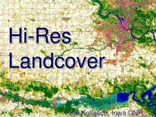
The Iowa GAP (IAGAP) initiative aims to develop a detailed stewardship map that outlines the geographical boundaries of public and private conservation lands across the state. This map attributes land units with essential details such as place names, ownership, management, and stewardship codes. By analyzing these attributes and the level of biodiversity protection (Status 1-5), IAGAP provides valuable insights into the conservation network's effectiveness. The data acquired from over 100 agencies will inform land managers, organizations, and private owners for improved ecosystem management and biodiversity preservation.

E N D
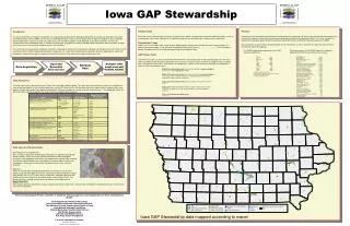
Iowa GAP Stewardship Attribute Data Each land unit was attributed with a minimum of a place name, owner, manager and associated stewardship codes as well as a management status code. Additionally if available the land unit was designated with its place name or equivalent. Stewardship Codes IAGAP uses a set of 4-digit codes similar to other GAP programs to differentiate the different owners and managers in a state’s conservation system. A list of all GAP stewardship codes can be seen at www.gap.uidaho.edu. The first two digits identify the agency with the last two digits representing the management type. GAP Status Code The GAP status code is a measure of the level of commitment a land unit provides for maintaining biodiversity. The status code is based on the permanence of protection from a natural to unnatural state, the amount of landcover within a landunit that is managed for natural cover, inclusiveness of management—species versus ecosystem and type of management—allows or mimics disturbance events. Analysis Completion of the stewardship map will allow the examination of stewardship and the level of protection offered throughout the conservation network in Iowa. Basic reporting will include tabulating the level of protection (Status 1,2,3,4) by steward. An analysis of conservation ‘gaps’ will also be performed using data from the vertebrate modeling component of IAGAP. Some preliminary analyses of the stewardship data can be seen below, as well as a preliminary representation of the final stewardship map in the large box. Introduction The goal of IAGAP was to compile a comprehensive stewardship map detailing the geographic boundaries of a majority of the public and private conservation lands in Iowa. IAGAP uses the term stewardship because in many cases the organization or agency managing an area is different than the legal owner of a parcel of land. Over 100 county, state and federal agencies were identified as possible contributors of ownership boundaries for Iowa’s stewardship map. In addition to collecting the geographic boundary of managed areas information about the owner, manager and a measure of intent to maintain biodiversity was also collected. The intent of the land stewardship component of IAGAP is to provide an indicator for the protection of biodiversity throughout the state. When used in conjunction with the habitat modeling and landcover components the map of land stewardship also provides agencies, organizations and private land owners the basic information to evaluate their land in the context of the entire conservation system of the state. The IAGAP stewardship map contains over 2250 uniquely named areas. Preliminary analysis of the IAGAP map units (landcover type) protected within conservation areas in Iowa. IAGAP Map Unit Open Water Upland Deciduous Forest Cool Season Grass Cropland Seasonally Flooded Forested Wetland Warm Season Grass/Perennial Forbs Temp Flooded Forested Wetland Grassland w/ Sparse Trees Sparsely Vegetated/Barren Semi-perm Flooded Wetland Upland Deciduous Woodland Permanently Flooded Wetland Mixed Evergreen/Deciduous Forest Temp Flooded Wetland Seasonally Flooded Wetland Seasonally Flooded Shrub Evergreen Forest Upland Shrub Artificial/High Vegetation Eastern Red Cedar Forest Temp Flooded Shrub Pine Forest Artificial/Low Vegetation Semi-perm Flooded Shrub Eastern Red Cedar Woodland Barren/Mixed Vegetation Mixed Evergreen/Deciduous Woodland Saturated Wetland Saturated Shrub Acres 194028 141426 85184 75547 37474 34196 32925 15904 13789 12986 12744 10989 10783 5881 5562 4226 3377 2972 2783 2106 1546 1447 1291 1194 888 733 596 179 8 Manager ACE* CCB system** City FWS IDNR INHF Local Gov. NPS Private*** TNC Acres 168086 148875 1541 75392 346618 2444 30 1296 36175 5650 Analysis with Landcover and Habitat models Data Acquisition Input and Reconcile data sources Attribute Data Status 1-Permanent protection from conversion through a management plan or intent, allow or mimic disturbance events Status 2-Permanent protection from conversion through a management plan or intent, suppression of natural disturbance or management practices that may degrade the quality of natural communities Status 3-Permanent protection but may be subject to extractive or intensive uses Status 4-No known institutional mandate or legal restrictions to prevent the conversion of natural areas, area generally allows conversion to unnatural landcover Status 5-Not managed for biodiversity *includes private flow easements **The County Conservation Board system involves 99 separate managing agencies. *** includes ACE easements Data Acquisition The Iowa Department of Natural Resources (IDNR) was invaluable in obtaining data. Their work with federal and county agencies throughout the state yielded many pieces of the stewardship puzzle in existing GIS data formats. After identifying other key organizations managing land in Iowa requests for data were made to the appropriate individuals. Data was available in a variety of formats and resolutions. The table below shows the data acquired for a particular agency, the source, format and approximate resolution. Data Input and Reconciliation Reconciliation of existing GIS data Much of Iowa’s conservation network was represented in a variety of existing GIS formats already. Pieces of existing GIS data received from GAP participants contained similar geographic information and attributes that required edge-matching or conflation. Another problem was contradictory information about ownership or management. Prior to construction of the final dataset these issues had to be resolved. Digitizing Almost all of the property owned/managed within the 99 County Conservation Boards (CCB) had to be digitized. Data was obtained on FSA aerial photos or paper maps directly from a CCB. In cases where no data was submitted information was transferred to aerial photos from information at the county Auditor’s Office. The photos were then scanned and referenced to allow on-screen digitization of property boundaries. Mapped Land Units Each property boundary identified as having a unique combination of land owner, land manager and biodiversity protection became a distinct land unit in the final database. The Iowa Gap Analysis Project would like to thank the following agencies and organizations for their contribution to IAGAP: Iowa Department of Natural Resources Iowa Association of County Conservation Boards The individual County Conservation Boards of Iowa Iowa Natural Heritage Foundation Natural Resources Conservation Service The Nature Conservancy U.S Fish and Wildlife Service U.S. Army Corps of Engineers For more information contact: Patrick Brown patrickb@iastate.edu Iowa GAP Stewardship data mapped according to owner