Tsunami
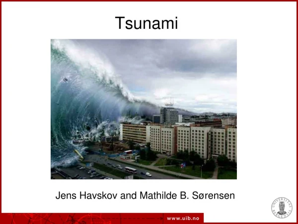
Tsunami. Jens Havskov and Mathilde B. Sørensen. A tsunami is an abnormal large wave hitting the coast. What is a tsunami. A surf wave can be considered a small tsunami. Danger of tsunami waves. Tsunami generation by an earthquake. Tsunami generation in a subduction zone.

Tsunami
E N D
Presentation Transcript
Tsunami Jens Havskov and Mathilde B. Sørensen
A tsunami is an abnormal large wave hitting the coast What is a tsunami
Tsunami generation in a subduction zone Deformation accumulates The fault slips, the sea bottom moves up and generates a wave in the water The wave starts to propagate towards the ocean and towards the coast
Tsunami propagation A tsunami propagation velocity is reduced in shallow water, while the height of its waves rapidly increases. Wave height in the open ocean is less than 1 m. The periods of the tsunami waves may vary between about 6 and 150 minutes.
www.geo.uib.no Recording tsunami signals on a tide gauge (From Milburn et al., 1996) Department ofEarthScience
www.geo.uib.no Instrument examples Department ofEarthScience
Pacific tsunami warning center (PTWC), how it works Use seismic data as its starting point. Takes into account oceanographic data when calculating tsunami threats. Tide gauges in the area of the earthquake are checked to establish if a tsunami wave has formed. The PTWC then forecasts the future of the tsunami, issuing warnings to at-risk areas all around the Pacific Basin. There are never false alarms--if the PTWC issues a tsunami warning for a particular area, the wave is already on its way and will hit. As it takes a hours for a tsunami to travel transoceanic distances, the PTWC can afford the time to make sure of its forecasts.
US Pacific tsunami warning system and zones of large shallow earthquakes
Single station warning system A single station can make a preliminary location and magnitude If M > 7, a warning isssued Problem: magnitude can normally only be determiend after some time and that may be too late
A tsunami earthquake generates proportinally little high frequency energy Also called a slow earthquake Traditional magnitude Ms is low compared to the tsunami it generates The earthquake magnitude is in this case a poor indcator of the tsunami potential. People might not take warning since ground shaking might be less than what is usually expected for a tsunami generating earthquake. Important to include frequency analysis is the seismic tsunami warning system Tsunami earthquake
Tsunami earthquakes source time functions Source time functions of normal subduction earthquakes Source time functions of tsunami subduction earthquakes Tsunami earthquakes rupture more slowly and radiates less energy
Sumatra earthquake, Dec 26, 2004, M=9.0 Subduction along the Sunda trench is the main source of significant earthquake activity in this region.
Sumatra seismic gap From CalTech (K. Sieh) In the region, there are at least six significant historical earthquakes that occurred prior to the 2004 event.
Deadly Norwegian fjord Tsunami in Tafjord , Norway was 63 m high 1934
This mountain side is now slowly sliding into the fjord. It can suddenly slide and the tsunami would destroy the village. The sliding is monitored by seismic stations and it is expected that a warning can be given. Future land slide in a Norwegian fjord Imaginary wave caused by the coming slide at the village.
ISTO, Orleans, Fr Plate tectonics in Japan Relative plate speed : ca. 8 cm/year
What was expected in Japan? Earthquakes M≥7 since 1900 From age of plate and subduction speed, a M=8.2 event was expected. USGS
What happened in Japan? A mega-earthquake: M=9.2 Lengh of breaking fault: ca 500 km Width of fault: ca 250 km Maximum displacment: 40-50 m Displacment on the sea bottom: 3-5 m
Measured accelerations in Japan Max horizontal accelration: 2.7g NIED
Tsunami walls Ca. 40% of the coast was protected by walls but they were too small
Japan eathquake - conclusion Much worked well: • The warning system worked • People knew what to do • Many lives were saved But… • The maximum size of earthquake in the region had been under estimated • Fukushima…
Historical tsunamis in the Caribbean Red markers are eqarthquakes > 8, yellow upward trianges are volcanic sources and downward triangles are landslide sources. 85 tsunamis,17 with fatalties, 15 000 dead since 1498.
Haiti earthquake generated a small tsunami, 3 fatalities Generally low risk to tsunmis in the Caribbean compared to the Pacific Both land slides and earhquakes have generated tsunamis
Conclusion Tsunamis are mainly generated by shallow earthquakes A first warming is the earthquake, continued seismic monitorin is therfore essential. Slow eartquakes or tsunami earquakes might underestimate tsunami potential Tide gauge used to get actual tsunami height and can be used to model probable wave hights