Download
1 / 49
510 likes | 1.19k Vues
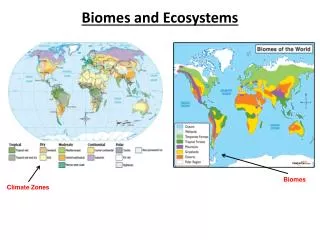
Learning Objectives. What are biomes?What major factors account for their distribution?What is species diversity?Which biomes yield the greatest species diversity?How are the earth's major terrestrial and aquatic biomes characterized?. A. BiomesMajor types of terrestrial ecosystems.Distribution of biomes largely depends on climate (temperature

E N D
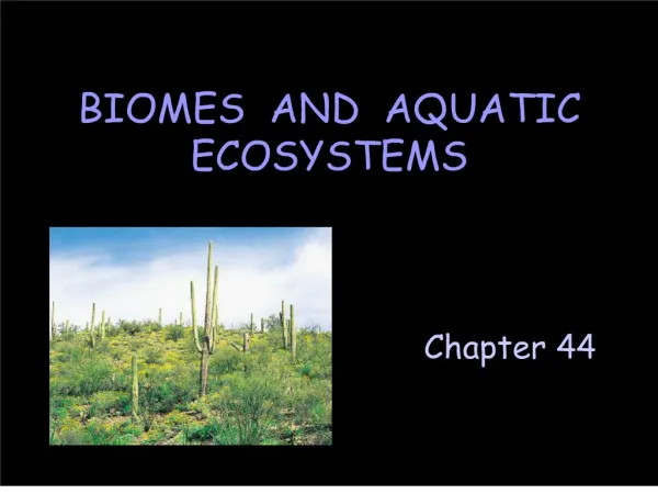
1. Chapter 44 BIOMES AND AQUATIC ECOSYSTEMS Sonoran Desert in the Southwestern United States.Sonoran Desert in the Southwestern United States.
3. A. Biomes
Major types of terrestrial ecosystems.
Distribution of biomes largely depends on climate (temperature & rainfall).
Climate is determined by the Earth�s tilt & uneven heating of Earth�s surface.
7. Unequal heating causes air movements that distribute moisture. Hot, moisture-laden air rises at equator. As air cools, it releases moisture as rain (rains almost continuously in tropics). Equatorial air travels north & south. The cooler the air, the more dense it becomes. Dense air sinks around 30o north & south latitude. As air sinks it absorbs moisture from land, creating vast deserts. Moist air continues movement toward poles. It rises & cools, releasing its moisture, around 60o north & south latitude. This rainfall supports temperate forests & grasslands. Moisture-depleted air continues to move toward the poles. This air eventually makes its way back to the equator.Hot, moisture-laden air rises at equator. As air cools, it releases moisture as rain (rains almost continuously in tropics). Equatorial air travels north & south. The cooler the air, the more dense it becomes. Dense air sinks around 30o north & south latitude. As air sinks it absorbs moisture from land, creating vast deserts. Moist air continues movement toward poles. It rises & cools, releasing its moisture, around 60o north & south latitude. This rainfall supports temperate forests & grasslands. Moisture-depleted air continues to move toward the poles. This air eventually makes its way back to the equator.
8. Hot, moisture-laden air rises at equator. As air cools, it releases moisture as rain (rains almost continuously in tropics). Equatorial air travels north & south. The cooler the air, the more dense it becomes. Dense air sinks around 30o north & south latitude. As air sinks it absorbs moisture from land, creating vast deserts. Moist air continues movement toward poles. It rises & cools, releasing its moisture, around 60o north & south latitude. This rainfall supports temperate forests & grasslands. Moisture-depleted air continues to move toward the poles. This air eventually makes its way back to the equator.Hot, moisture-laden air rises at equator. As air cools, it releases moisture as rain (rains almost continuously in tropics). Equatorial air travels north & south. The cooler the air, the more dense it becomes. Dense air sinks around 30o north & south latitude. As air sinks it absorbs moisture from land, creating vast deserts. Moist air continues movement toward poles. It rises & cools, releasing its moisture, around 60o north & south latitude. This rainfall supports temperate forests & grasslands. Moisture-depleted air continues to move toward the poles. This air eventually makes its way back to the equator.
10. Learning Objectives What are biomes?
What major factors account for their distribution?
What is species diversity?
Which biomes yield the greatest species diversity?
How are the earth�s major terrestrial and aquatic biomes characterized?
13. Species Diversity � H�, has Two Components: Evenness � E --- addresses the equitability of individuals across all species. High evenness increases species diversity.
Richness � S --- simply the number of species in a community. The greater the number of species, the greater the diversity.
14. Which Community Has the Greater Diversity, A or B?
15. Which Community Has the Greater Diversity, A or B?
19. Learning Objectives What are biomes?
What major factors account for their distribution?
What is species diversity?
Which biomes yield the greatest species diversity?
How are the earth�s major terrestrial and aquatic biomes characterized?
20. Text discusses 8 biomes.Text discusses 8 biomes.
21. Terrestrial Biomes Tropical Rain Forest
Desert
Temperate Grassland
Temperate Deciduous Forest
Taiga or Northern Coniferous Forest
Tundra
23. Tropical Rain Forest Nutrients cycle rapidly because of warm, moist conditions.
Soils are poor in nutrients because water leaches them away. Fortunately, the roots of giant trees are extremely efficient at absorbing nutrients - most nutrients released during decomposition are absorbed before they are leached away by rain water.
Vertical stratification - layering of different plant species from forest floor to the canopy. Stratification occurs because plants compete for sunlight. Plants have adapted in different ways to capture sunlight (epiphytes). Nutrients cycle rapidly because of warm, moist conditions.
Soils are poor in nutrients because water leaches them away. Fortunately, the roots of giant trees are extremely efficient at absorbing nutrients - most nutrients released during decomposition are absorbed before they are leached away by rain water.
Vertical stratification - layering of different plant species from forest floor to the canopy. Stratification occurs because plants compete for sunlight. Plants have adapted in different ways to capture sunlight (epiphytes).
26. Desert Sahara desert in Africa is largest desert.Sahara desert in Africa is largest desert.
27. animals adapted to minimize water loss
tough, waterproof integument
concentrated urine
nocturnal habits Atriplex is able to utilize water from beneath the salt flats of deserts. Other plants are unable to utilize this water because their tissues would lose water to the salty soil via osmosis.
Certain animals (red vizcacha rat, kangaroo rat & fat sand rat) can feed on Atriplex because they have developed adaptations (bristle bundles in mouth) that aid in stripping the plants of their salty coverings, exposing the less salty tissues within.Atriplex is able to utilize water from beneath the salt flats of deserts. Other plants are unable to utilize this water because their tissues would lose water to the salty soil via osmosis.
Certain animals (red vizcacha rat, kangaroo rat & fat sand rat) can feed on Atriplex because they have developed adaptations (bristle bundles in mouth) that aid in stripping the plants of their salty coverings, exposing the less salty tissues within.
28. Temperate Grasslands (prairie)
30. Temperate Forests Deciduous trees shed leaves seasonally.
Coniferous trees remain green year round.
Adaptations to winter in temperate deciduous forest:
Trees drop leaves
Insects enter diapause
Some mammals hibernate
Birds migrate southwardDeciduous trees shed leaves seasonally.
Coniferous trees remain green year round.
Adaptations to winter in temperate deciduous forest:
Trees drop leaves
Insects enter diapause
Some mammals hibernate
Birds migrate southward
32. Taiga or Northern Coniferous Forest Conifers are adapted to long, cold, harsh winters.
Needle design is designed to reduce water loss.
Conical tree shape captures oblique rays of sun & prevents damaging snow & ice buildup.Conifers are adapted to long, cold, harsh winters.
Needle design is designed to reduce water loss.
Conical tree shape captures oblique rays of sun & prevents damaging snow & ice buildup.
35. Tundra Permafrost - permanently frozen ground.
Growing season is less than 60 days.Permafrost - permanently frozen ground.
Growing season is less than 60 days.
36. Aquatic Biomes (Ecosystems) Freshwater
Standing Water � lakes, ponds, bogs, swamps
Running Water � streams, rivers
Marine
Coastal � estuaries, mangrove swamps, intertidal zone, coral reefs
Ocean
37. B. Aquatic Ecosystems
1. Freshwater Ecosystems
Lakes and Ponds (standing water) Littoral zone - shallow area where light reaches the bottom; contains the greatest number & diversity of organisms (rooted plants, phytoplankton, zooplankton, insects, fish, reptiles).
Limnetic zone - upper layer of open water; extends down as far as light reaches. Find phytoplankton, zooplankton & fishes.
Profundal zone - deeper layer of open water; light does not penetrate. Find scavengers & decomposers.
Benthic zone - lake bottom. Find scavengers & decomposers.Littoral zone - shallow area where light reaches the bottom; contains the greatest number & diversity of organisms (rooted plants, phytoplankton, zooplankton, insects, fish, reptiles).
Limnetic zone - upper layer of open water; extends down as far as light reaches. Find phytoplankton, zooplankton & fishes.
Profundal zone - deeper layer of open water; light does not penetrate. Find scavengers & decomposers.
Benthic zone - lake bottom. Find scavengers & decomposers.
39. Physical/Chemical Factors Important in Lakes
Radiant Energy
Permits Photosynthesis
Produces Heat
Temperature
Effects metabolic rates of resident species
Influences rate of decomposition
Effects water density
40. Physical/Chemical Factors Important in Lakes � Cont�d. Oxygen
Influences rate of metabolism
Influences rate of decomposition
Solubility of O2 in water is effected by temperature and exchange with atmosphere
Water Clarity (inverse of turbidity)
Effects photosynthesis - and thus food chain
Effects heating
49. What Are The Consequences of Turnover (i.e. Total Mixing)? O2 gets redistributed throughout the water column.
The gases of decomposition get released to the surface of the lake.
Nutrients (N,P and K) that accumulated at the bottom due to organisms dying and sinking are released throughout the water column.
50. Oxygen & nutrients (nitrogen/phosphorus) are unevenly distributed in lakes.
O2 level is highest near surface
nutrient level is highest near bottom
Oxygen & nutrients are redistributed by:
wind (ponds & shallow lakes)
fall & spring turnover (deep lakes in temperate regions) Fall turnover: oxygen-rich surface waters sink to the bottom when they cool to 39?F (4?C) [temperature at which water is densest] Colder, nutrient-rich water will float above the 39?F layer & may freeze.
Spring turnover: oxygen-rich surface waters sink to bottom when they warm to 39?F. Colder, nutrient-rich water will rise to surface.Fall turnover: oxygen-rich surface waters sink to the bottom when they cool to 39?F (4?C) [temperature at which water is densest] Colder, nutrient-rich water will float above the 39?F layer & may freeze.
Spring turnover: oxygen-rich surface waters sink to bottom when they warm to 39?F. Colder, nutrient-rich water will rise to surface.
51.
Oligotrophic lakes
young; low in nutrients & productivity
clear & sparkling blue
deep water is oxygen-rich
Eutrophic lakes
older; nutrient rich & high in productivity
green & murky
O2 often depleted in deep water during summer
Nutrients in sewage & agricultural runoff speed eutrophication. Eutrophication - rapid conversion of oligotrophic lakes to eutrophic lakes; caused by introduction of nutrients from sewage or fertilizer runoff.Eutrophication - rapid conversion of oligotrophic lakes to eutrophic lakes; caused by introduction of nutrients from sewage or fertilizer runoff.
52. The Process of Eutrophication Defined as the enrichment of a body of water and subsequent increase in productivity.
Occurs naturally but at a slow pace over geological time
Human activities greatly accelerate the process of eutrophication:
Increased nutrient input from fertilizer mismanagement
Nutrients associated with sewage
53. Rivers and Streams (running water)
Transport rainwater, groundwater, snowmelt & sediment from land to ocean or lake. Organisms that live near headwaters are adapted to swift currents (streamlined bodies, possess hooks or suckers).Organisms that live near headwaters are adapted to swift currents (streamlined bodies, possess hooks or suckers).
54. 2. Marine Ecosystems
Coastal Ecosystems
Include estuaries, mangrove swamps, the intertidal zone & coral reefs.
Estuary - area where fresh water of river meets salty water of ocean.
56. Mangrove Swamp � a type of estuary in which a tropical wetland is dominated by salt-tolerant plants (mangroves).
57. Intertidal Zone - area along coast between high & low tides.
58. Ocean Ecosystem
covers 71% of Earth�s surface
temperature: 35oF - 81oF
sunlight quickly dissipates with depth
primary producers are photoautotrophs (found near surface) & chemoautotrophs (found at deep-sea hydrothermal vents)
highest productivity near upwellings (occurs on western side of continents) Light does not extend below 600 meters. Photosynthesis cannot occur below 200 meters.Light does not extend below 600 meters. Photosynthesis cannot occur below 200 meters.
59. Upwellings Warm, light surface water is displaced by strong winds
Then, colder, nutrient-rich water is able to rise to the surface from the aphotic zone of the ocean
Thus, algal productivity and the entire epilimnetic food chain is greatly enriched
60. Horizontal zones describe relationship between ocean and land.
Intertidal zone - coastal area between high & low tides.
Neritic zone - area extending from low tide mark to edge of continental shelf (~ 200 meters).
Oceanic zone - area extending beyond continental shelf.
Vertical zones describe ocean in terms of depth.
Benthic zone - ocean bottom
Pelagic zone - water above benthic zone.
Epipelagic zone - surface to 200 meters; only area where photosynthesis can occur. [light extending below 200 meters is insufficient for photosynthesis]
Mesopelagic zone - 200-1000 meters
Bathypelagic zone - 1000-4000 meters
Abyssal zone - 4000-6000 meters
Hadal zone - below 6000 meters; region where hydrothermal vents are located.Horizontal zones describe relationship between ocean and land.
Intertidal zone - coastal area between high & low tides.
Neritic zone - area extending from low tide mark to edge of continental shelf (~ 200 meters).
Oceanic zone - area extending beyond continental shelf.
Vertical zones describe ocean in terms of depth.
Benthic zone - ocean bottom
Pelagic zone - water above benthic zone.
Epipelagic zone - surface to 200 meters; only area where photosynthesis can occur. [light extending below 200 meters is insufficient for photosynthesis]
Mesopelagic zone - 200-1000 meters
Bathypelagic zone - 1000-4000 meters
Abyssal zone - 4000-6000 meters
Hadal zone - below 6000 meters; region where hydrothermal vents are located.