Plate Tectonics Map Project
Plate Tectonics Map Project. Your Goal: Create your own fictional world complete with continents, oceans, tectonic plates, mountains, earthquakes, volcanoes, and other evidence of a dynamic earth .
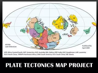

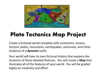
Plate Tectonics Map Project
E N D
Presentation Transcript
Your Goal: Create your own fictional world complete with continents, oceans, tectonic plates, mountains, earthquakes, volcanoes, and other evidence of a dynamic earth. Your world will have its own fictional history that explains the locations of these detailed features. You will create a Mapthat illustrates all of the features of your world. You will be graded highly on creativity and effort.
What Should Your Final Map Look Like?? • Maps should be the size of poster board • Maps should have a recognizable theme • Maps can be 2D or 3D (3D = extra credit) • Maps should include; continents, oceans, plates, plate boundaries, and crustal formations • Continents, oceans, and crustal formations mustbe named – you do not have to include plate boundary names on your final project • All of the features described above should be placed appropriately on your map • Include a small drawing of your "Original Super Continent" • Include your plate boundaries map • Final map should be in full color, neat, and organized
Day One – Plate Movement / Naming Create a plate boundaries map showing plate movement. Maps should be broken into 10 tectonic plates and include convergent, divergent, and transform boundaries. Add arrows to show plate movement. You must get this map signed off on by your teacher to move on. You will also turn this map in as part of your grade. Plate movements must make sense! Checkpoint: ___10 tectonic plates ___Convergent, divergent, and transform boundaries are present ___Arrows to show movement ___Movement is logical _________________________Teacher Signature
Day One – Plate Movement / Naming continued Begin brainstorming what your world is going to look like. YOU MUST HAVE A THEME! Create a small sketch of your “Pangaea”. You will need to include a picture of your “Pangaea” on your final project. Break your “Pangaea” into 7 continents. Choose continentalshapes that demonstrate ahistory of plate movement, collisions, and changes. Name your continents, oceans, and plates. Add the names to your project worksheet. Also add the plate names to your plate boundaries map. Checkpoint: ___Pangaea has been created and cut into 7 continents ___Continents named ___Oceans named ___Plates named _________________________Teacher Signature
Day Two – Boundaries / Crustal Formations: Find locations for your continents on your plate boundaries map. The location of the continents should start to tell a story of the past. Depending on where your continents are, add oceans to your map (at least 4 oceans). As you place your continents on the map, remember that you should have oceanic-oceanic, oceanic-continental, and continental-continental margins. You'll address what features you would find across your world later on. Checkpoint: ___Oceanic/Oceanic boundaries ___Oceanic/Continental boundaries ___Continental/Continental boundaries _________________________Teacher Signature
Day Two – Boundaries / Crustal Formations: Start deciding what types of features you are going to find along your plate boundaries. For example, if you have a divergent boundary between two oceanic plates you should place a Mid-Ocean Ridge along this boundary. Label your map and use the Project Worksheet to record the names of the crustal formations. Crustal Formations should include: Mid-Ocean Ridges, Rift Valleys, Fault Zones, Trenches, Volcanic Mts., Island Arcs, and Folded Mountains. Remember some formations come in pairs. For example if you have an oceanic/oceanic convergence you should have a trench and island arc near the boundary.
Day Two – Boundaries / Crustal Formations: Checkpoint: ____Rift Valleys ____Mid-Ocean Ridges ____Faults ____Trenches ____Volcanic Mtns ____Folded Mtns ____Island Arcs ____Formations are placed correctly _________________________Teacher Signature
Your rough draft should now be complete! You’re ready to start making your final product!
Rubric Use this tool to help make sure you include everything on your map
Plate Boundary Map / Poster Sketch of your super continent, your “Pangaea” Completed Checklist Project packet with: 1) name 2) rubric 3) checkpoints signed by teacher You will be responsible for:
Project Due on : Friday, February 21st Your Goal: Create your own fictional world complete with continents, oceans, tectonic plates, mountains, earthquakes, volcanoes, and other evidence of a dynamic earth. Your world will have its own fictional history that explains the locations of these detailed features. You will create a Map that illustrates all of the features of your world. You will be graded highly on creativity and effort.