Download

1 / 1
10 likes | 158 Vues
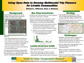
Center for Urban Transportation Research. Using Open Data to Develop Multimodal Trip Planners for Livable Communities. Edward L. Hillsman, Sean J. Barbeau. Background. Routing. Bus Stop Inventories.

E N D
Center for Urban Transportation Research Using Open Data to Develop Multimodal Trip Planners for Livable Communities Edward L. Hillsman, Sean J. Barbeau Background Routing Bus Stop Inventories • Trip planning is important for transit, cycling, and walking, since pedestrian networks are dense and complex. • However: • data describing pedestrian networks are less complete than major road networks • more features are important (bike parking, intersection characteristics, crosswalks, curb cuts, slope, presence of shade) • data are expensive to collect and maintain by conventional means. • Can openly shared data from organizations (e.g., Departments of Transportation) and the community (e.g., OpenStreetMap.org) be used for multimodal trip planning? • OpenTripPlanner.org (OTP), an open-source multimodal trip planning solution, leverages OpenStreetMap and GTFS data. • OTP is developing rapidly and is being used in production trip planning systems • Attributes of intersections are important to comfort, safety, risk, and accessibility. Representing intersections as nodes may not capture features important to travelers • Can we easily import existing datasets into OpenStreetMap to quickly fill out community data? • There is a lack of standards for what to display for bike or walk routes, and how to display it • Need to accommodate different navigation styles (visual vs. procedural) • Problem: Bus stop inventories are often outdated, inaccurate, and costly to maintain • Solution: Synchronize bus stops from a transit agency’s General Transit Feed Specification (GTFS) dataset with OpenStreetMap (OSM) • GO-Sync software tool enables agency to upload bus stop data to OSM, and retrieve “crowd-sourced” edits from the public(e.g., location corrections, new attributes of benches or shade) • GO-Sync also synchronizes new agency GTFS data when bus stops & service changes Challenges: Levels-of-service (LOS) • Bicycle and pedestrian LOS measures use speed and volume of car traffic. • Open Issue: These data are hard to crowd-source. Can other LOS measures be derived using objective values that are easier to measure? GO-Sync – An Open-Source Project to Sync General Transit Feed Spec. Data with OpenStreetMap Research funded by the National Center for Transit Research and the Florida Department of Transportation http://code.google.com/p/gtfs-osm-sync/