Download
1 / 45
450 likes | 609 Vues
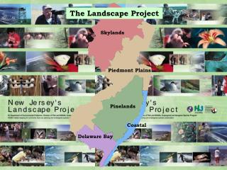
The Landscape Project. Skylands. Piedmont Plains. Pinelands. Coastal. Delaware Bay. Creating the Landscape Project. Critical Area Ranking :. (1) Suitable Habitat - Meets suitability requirement defined for each habitat type.

E N D
The Landscape Project Skylands Piedmont Plains Pinelands Coastal Delaware Bay
Creating the Landscape Project Critical Area Ranking: (1) Suitable Habitat - Meets suitability requirement defined for each habitat type. (2) State Priority - At least one state priority species is present. (3) State Threatened - At least one state threatened species is present. (4) State Endangered - At least one state endangered species is present. (5) Federally Listed - At least one federally listed species is present.
Creating the Landscape Project A multi-step process is used to delineate critical forest areas in watershed management area 8: (1) 1995/1997 Land use/Land cover types (2) Forest types extracted from LU/LC (3) Contiguous patches created by dissolving boundaries between adjacent forest polygons (4) Ecologically significant boundaries created by bisecting contiguous forest patches using major roads (5) Forest patches meeting the minimum core size (6) Species point locations overlaying the forest coverage (7) Species models intersected with the forest patches. (8) Habitat patches are ranked based on the conservation status of species present.
Forest Attribute Table Contiguous Forest Patch Forest Species Look-up Table
Components of a Shapefile .shp – shape of geographic feature; either point, line or polygon .dbf – database file that holds attribute data for shapes .shx – link file that maintains relation between shapes and attributes .sbn & .sbx – temporary index files that are modified when editing shapes or attributes
Shapefile Attributes • Link- unique ID for each patch of habitat • Perimeter, Area, Acres, Hectares- of the patch • Version- used to track release of data set • Suitable- whether or not patch meets habitat-specific suitability requirements • Priority- number of priority species records in a patch • Threatened- number of threatened species records found in a patch • Endangered- number of endangered species records found in a patch • Federal- number of federal species records found in a patch • Rank- conservation status of a patch based on species presence
Species Look-up Table Attributes • Link- unique ID for each patch of habitat, used to link species tables to habitat shapefiles • Species- name of species found in a patch • Count- number of species records found in a patch
Forest Attribute Table Contiguous Forest Patch Forest Species Look-up Table
Software • ArcExplorer - free, lightweight GIS data viewer for performing basic GIS functions. • ArcView 3.x - full-blown desktop GIS for creating, editing, and managing geographic data. • ArcGIS 8.x - maintains same functions as 3.x, but with additional capability and power. • i-MapNJ - created with ArcIMS (Internet Mapping Service), an online geographic information system for New Jersey.
Useful Web Addresses • Endangered and Nongame Species Program • http://www.njfishandwildlife.com/ensphome.htm • The Landscape Project • http://www.state.nj.us/dep/fgw/ensp/landscape/download.htm • Conserve Wildlife Foundation of NJ • http://www.conservewildlifenj.org/ • Division of Fish and Wildlife • http://www.nj.gov/dep/fgw/ • Bureau of Geographic Information Systems • http://www.nj.gov/dep/gis/ • i-MapNJ • http://www.state.nj.us/dep/gis/depsplash.htm • Department of Environmental Protection • http://www.state.nj.us/dep/
Zoom to an area Certain Layers only visible at specific scale
Click refresh More layers become available Make beach active Make all Landscape layers visible
Click Identify tool Click on patch View results
Creating the Landscape Project • Base Data: Version 1.0 vs. Version 2.0 • Version 1.0: CRSSA LU/LC • Raster-based classification • Raster layers are based on a regularly • spaced grid with rectangular cells • Easily updated to reflect changes in • landscape • Version 2.0: DEP LU/LC • Vector-based classification • Vector layers are based on individual points, lines, and polygons that can depict irregular shapes accurately • Maintains consistency with DEP Aerial photography CRSSA raster-based LU/LC DEP vector-based LU/LC
Creating the Landscape Project • Base Data: NJDEP 1995/1997 land use • Statewide land use digitized from • aerial photography. • 66 separate land use • classifications/types.
Creating the Landscape Project • Base Data: DEP Land use • 66 land use classes are grouped based on similarity in type. • Urban and other non-suitable land use types are erased. • Boundaries between similar types are dissolved and contiguous patches are formed. • Result: 5 Habitats (Emergent Wetlands, • Forested Wetlands, Forest, Grassland, Beach). Types grouped Urban areas erased Boundaries dissolved
Creating the Landscape Project • Base Data: Erase by Major Roads • Major Roads (county 500 level and above) are used to delineate contiguous patches for each habitat type.
Creating the Landscape Project • Base Data: The Five Habitat Types • Emergent Wetland • Forested Wetland • Forest • Grassland • Beach
Creating the Landscape Project Digital Wildlife Data: Citizen Scientist Volunteers ENSP Surveys and research Natural Heritage BCD
Creating the Landscape Project Species: Conservation status & habitats valued
Creating the Landscape Project Digital Wildlife Data: Eastern Tiger Salamander Sighting Point
Creating the Landscape Project 1. Map E Tiger Salamander sighting point. 2. Buffer point with 300 meter radius. Apply model Rank patches model overlays 3. Value habitat patches with buffer.
Additional Layers for Version 2.0 3 Stand-alone Layers: • Bald Eagle Foraging • Urban Peregrines • Wood Turtle
Creating the Landscape Project Bald Eagle Foraging Areas: • 660 hectares of foraging habitat (open water bodies > 8 hectares) is identified around the nest • Open water is clipped once it reaches 660 ha • Emergent Wetlands added • Emergent Wetland patches that intersect open water are combined with open water • A 90 meter buffer is applied to complete the Bald Eagle Foraging Area for this nest
Creating the Landscape Project Urban Peregrine Falcon Nests: • Peregrine Falcon nests in urban areas are given a 1 km buffer
Add wetlands Streams buffered by 0.2 miles Take out urban Add wetlands Take out urban Points + 1 mile radius buffer Creating the Landscape Project Wood Turtle Populations:
The Dynamic Landscape Project
Creating the Landscape Project Habitat-specific Requirements: • Grassland patches must meet a minimum size of 18 hectares in order to be considered suitable (rank = 1) , unless the patch is intersected by a species model • Emergent Wetland, Forested Wetland, and Beach patches are considered suitable (rank = 1) regardless of size • Coastal region forest patches are considered suitable (rank = 1) regardless of size • All Emergent Wetland, Forested Wetland, Forest, and Grassland patches in the lower 10 kilometers of the Cape May peninsula are considered critical (rank = 4) due to migratory raptors • Pinelands forest patch connection corridors must be a minimum of 300 feet in width and less than 300 feet in length in order to be considered a contiguous tract of forest • Forest patches statewide must meet a minimum of 10 hectares core in order to be considered suitable (rank = 1) , unless the patch is intersected by a species model • Barred Owl, Red-Shouldered Hawk, and Bobcat only value forest patches that meet the minimum core requirement
Creating the Landscape Project 3 Species that only value Core Forest: • Bobcat, Barred Owl & Red-shouldered hawk
Use the zoom in tool to locate area in question
To make a theme active
Click the identify tool to obtain the link ID Raised gray outline appears
Get Link ID Click the patch in question
Land Use Regulation Program http://www.state.nj.us/dep/landuse/