Download
1 / 29
300 likes | 470 Vues
GROUP 4 FATIN NUR HAFIZAH MULLAI J.DHANNIYA FARAH AN-NUR MOHAMAD AZUWAN LAU WAN YEE. INTRODUCTION TO GEOGRAPHICAL INFORMATION SYSTEM. INTRODUCTION TO GIS. Used to describe computer facilities which are used to handle data referenced to the spatial domain.

E N D
GROUP 4 FATIN NUR HAFIZAH MULLAI J.DHANNIYA FARAH AN-NUR MOHAMAD AZUWAN LAU WAN YEE INTRODUCTION TO GEOGRAPHICAL INFORMATION SYSTEM
INTRODUCTION TO GIS • Used to describe computer facilities which are used to handle data referenced to the spatial domain. • Has the ability to inner- relate datasets and to carry out functions to improve their analysis and the presentation of the results.
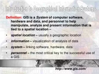
DEFINITON OF GIS • GIS is defined as “ a set of tools for collecting, storing, retrieving at will, transforming and displaying spatial data from the real world for a particular set of purposes.” • A computerized system for capturing, checking, manipulating analyzing and displaying data related to positions on or near the earth’s surface.
EVOLUTION (from mapping to GIS) • Topological technique permitted the data not only to determine where a point or a line or an area was located but also to analyze those features. • GIS data can be assembled by -existing databases -digitized or scanned from existing maps -GPS surveying techniques
DEVELOPMENT WITH MODERN GIS • Modern GIS developments are based on a data theory. • There are several aspects are considered:
GIS specific characteristic a) location-coordinates and street address b) attributes-features that being analyzed • GIS activities can be by two board field a) geographic b) cultural
ADVANTAGES • Storage and easily update data • Sort and store spatial features • Allow to zoom into section of data to graphic and text which may be hidden • Analyze both entities and data using sophisticated computer programs • Allow user to prepare maps
Allow user to use data to prepare maps at different scales • Allow to import stored data electronically and save the cost of collecting data • Build and augment a database • Create new maps by modeling or reinterpreting existing data
GIS SPECIFIC FEATURES • LIS - computerized, parcel-based land cadastre including the ongoing subdivision into real-estate development • AM/FM - important field of GIS field activity with macro-application in the management of municipal entities.
GIS-T - transportation represents a large and unique sphere of GIS activity • Proceeding to a New Information Utility - computer revolution were the simple procedures developed for computing and storing the coordinates • Natural Map - this graphical database was subsequently digitized to create the beginning of national digital database.
COMPONENTS OF A GIS • It can be divided into 4 major activities: - Data collection and input. - Data storage and retrieval. - Data analysis. - Data output and display.
GIS TYPICAL COMPONENTS: • The computer with GIS software is the main component and typically uses Microsoft or Unix operating systems. • Data collection can be divided into geometrics components that are: - Field surveying, - Remote sensing, - Digitalization of existing maps and plans, - Digital data transfer via Internet or CD/DVD
Computer storage: - Hard disks, - Optical disks etc. • Software designed are to download, edit, sort and analyze data. • It also designed to process and present data in the form of graphics and maps and/or plans.
SOURCES FOR GIS DATA: • The most important part of G.I.S is the collection of data. • If data can be obtained from other sources, the efficiency of the process increases. • Traditional sources for data collection: - Field surveying. - Remotely sensed images. - Existing topographic maps, plans etc. - Electronic transfer of previously digitalized data from Government agencies or commercial firms.
GIS DATA STRUCTURE • GIS data structure can be divided into • Spatial data • Attribute data
In vector data format, the basic unit of spatial information are points, lines and areas. • Each units is composed as a series of one or more coordinate points. • By using vector systems, there are 3 types of objects possible: • Nodes • Arcs • Polygons
RASTER DATA FORMAT • Consists of a set or matrix of cells or pixels of a specific size and area. • The image represent a scanned map or an aerial photograph of the site to be modeled. • Point is represented by a single grid cell, a line by consecutively neighboring cells and an area by a cluster of neighboring cells. • Can be for merging and investigating the vectorising method for a specific purpose • Example : raster image with a vector image for movement of river
GEOREFERENCING: • Most geographic data users have the same earth- reference techniques that the data can be shared by using various computer systems. • Coordinate Grids: • The plane coordinate grid systems 1983 (SPCS83) has been applied to all states. • Software programs readily convert coordinates based on one projection.
Transformation: • If a GIS is tied to a specific coordinate grid and orientation, the new data needs to be transformed to fit the working model. • Transformations can be made in: - Grid reference, - Scale - Orientation. • The computer programs designed to translate from one grid reference to another, convert the scale, and rotate to appropriate orientation.
DATABASE MANAGEMENT: • To organize the data so that the information about entities and their attributes can be accessed by rapid computerized search and retrieval techniques. • Data collections can range in complexity.
METADATA: • Metadata are “ data about data.” • It describe the content, quality, condition, and other characteristics of data. • The Federal Geographic Data Committee lists the different aspects of data described by metadata: • A) Identification – What is the name of the data set? • B) Data Quality – How good are the data?
Spatial Data Organization – What spatial data model was used to code the spatial data? • Spatial Reference – Are coordinate locations encoded using longitude and latitude? • Entity and Attribute Information – What geographic information is included? • Distribution – From whom can you obtain the data? • Metadata Reference – When were the metadata compiled?