Download
1 / 12
120 likes | 265 Vues
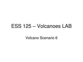
Volcanoes LAB. 2. 3. 1000. 5. 1. 4. 1000. Rivers & streams. Locations of pictures. 2. Contour line. N. Logging forest. 2000. Suburbs (growing). Major metropolitan area (city). 10 km. Contour interval = 1000 feet. 2. 3. 1000. 5. 1. 4. 1000. N. 2000. Major roads.

E N D
2 3 1000 5 1 4 1000 Rivers & streams Locations of pictures 2 Contour line N Logging forest 2000 Suburbs (growing) Major metropolitan area (city) 10 km Contour interval = 1000 feet
2 3 1000 5 1 4 1000 N 2000 Major roads Smaller roads Small town or village Numbers indicate locations of volcanic deposits (see following slides). 10 km Contour interval = 1000 feet
Volcano Scenario 6 – History of Eruptions • Large eruptions involving multiple hazards occurred about 13,000 years ago and about 6,000 years ago. For the past 2,900 years, only small eruptions have happened. The small eruptions involved the growth and collapse of lava domes with small lahars and pyroclastic flows at about 2900 and 2000 years ago, and again between 850-1200 years ago (multiple events). • In the most recent events, lahars and pyroclastic flows have traveled up to 15 km from the vent, but most are smaller. Ash from an eruption about 6,000 years ago can be found 100’s of kilometers away, and had a total volume beween 10-100 km3. Most ash deposits are more localized, closer to the volcano.
Volcanic deposits (3 different deposits). Middle layer is about 2 feet thick. Location 1 on map.
Volcanic deposit along road at Location 4 on map. hammer handle in center is about 40 cm long (about 16 inches)
Volcanic deposit. Location 3 on map. Largest block is about 1 foot across.
Volcanic deposit – location 3. Note cracks radiating from the center of this block. This indicates a significant difference in temperature between the block (hot) and surrounding matrix (cold).
Volcanic deposit along road at Location 5. Close-up of this rock (below right).
Young volcano deposit near summit. Note small glaciers at summit. Photo source: U.S. Geological Survey