Maritime zones
Maritime zones. Maritime Zones. Internal waters . Waters on the landward side of the baseline. The coastal state exercises full sovereignty, and these waters form an integral part of the state’s territory. Includes rivers, lakes and bays.

Maritime zones
E N D
Presentation Transcript
Maritime Zones Internal waters. Waters on the landward side of the baseline. The coastal state exercises full sovereignty, and these waters form an integral part of the state’s territory. Includes rivers, lakes and bays. Territorial Sea. The belt of water 12 nautical miles from from the baseline. The sovereignty of the coastal state extends to the territorial sea, its seabed and subsoil, and to the air space above it. That sovereignty is subject solely to the right of innocent passage for foreign ships. Contiguous Zone. The belt of water contiguous to the territorial sea, the outer limit of which does not exceed 24 nautical miles from the baseline. The coastal state exercises control necessary its customs, fiscal, immigration or sanitary laws.
UNCLOS. Legal status of the territorial sea,of the air space over the territorial seaand of its bed and subsoil 1. The sovereignty of a coastal State extends beyond its land territory and internal waters and, in the case of an archipelagic State, its archipelagic waters, to an adjacent belt of sea, described as the territorial sea. 2. This sovereignty extends to the air space over the territorial sea as well as to its bed and subsoil.
Innocent Passage Passage not prejudicial to the peace, good order or security of the coastal State Not innocent: • (a) any threat or use of force against the sovereignty, territorial integrity or political independence of the coastal State, …. • (b) any exercise or practice with weapons of any kind;… • (g) the loading or unloading of any commodity, currency or person contrary to the customs, fiscal, immigration or sanitary laws and regulations of the coastal State; • (h) any act of wilful and serious pollution contrary to this Convention; • (i) any fishing activities; • (j) the carrying out of research or survey activities;
Territorial Baselines The line from which the maritime zones are measured. Drawn at the low water line along the coast, including the coasts of islands. Straight baselines are a system of straight lines joining specified or discrete points on the low-water line. “Must not depart to any appreciable extent from the general direction of the coast, and the sea areas lying within the lines must be sufficiently closely linked to the land domain to be subject to the regime of internal waters.” Bay- or river-closing lines are straight lines drawn between the respective low-water lines of the natural entrance points of bays or rivers
Bays “A well-marked indentation whose penetration is in such proportion to the width of its mouth as to contain land-locked waters and constitute more than a mere curvature of the coast. [I]ts area [must be at least] as large as [a] semi-circle whose diameter is a line drawn across the mouth of that indentation.”
High Seas Not subject to the sovereignty or jurisdiction of any state Subject to the freedom of the high seas, namely: a) freedom of navigation; (b) freedom of overflight; (c) freedom to lay submarine cables and pipelines (d) freedom to construct artificial islands and other installations (e) freedom of fishing (f) freedom of scientific research
Continental Shelf “The natural prolongation of its land territory to the outer edge of the continental margin” Consists of the seabed and subsoil of the shelf, the slope and the rise Extends to at most 200 nautical miles from the baselines Largely coextensive with the Exclusive Economic Zone likewise covering 200 nautical miles from the baselines Can be extended to the outer edge of the continental margin
Exclusive Economic Zone The area beyond the territorial sea, not exceeding 200 nautical miles from the baseline. The coastal state has sovereign rights • for the purpose of exploring and exploiting, conserving and managing • all natural resources of the waters superjacent to the seabed and • of the seabed and its subsoil • together with other activities such as the production of energy from water, currents and wind • the establishment and use of artificial islands, installations and structures, marine scientific research, the protection and preservation of the marine environment
1898 Treaty of ParisTreaty of Peace Between the United States and Spain(10 December 1898) Article 3. Spain cedes to the United States the archipelago known as the Philippine Islands, and comprehending the islands lying within the following line: ….
Felipe Agoncillo's Protest to the US Senate during the debates on the Treaty of Paris • “If the Spaniards have not been able to transfer to the Americans the rights which they did not possess; • if the [Americans] have not militarily conquered positions in the Philippines; • if the occupation of Manila was a resultant fact, prepared by the Filipinos; • if the … representatives of the Republic of the USA offered to recognize the independence and sovereignty of the Philippines, solicited and accepted their alliance • how can they now constitute themselves as arbiters of the control, administration and future government of the Philippine Islands?”
Constitutional Framework of Philippine Treaty Obligations under the UNCLOS • No treaty or international agreement shall be valid and effective unless concurred in by at least two-thirds of all the Members of the Senate. (Const. art. VII sec. 21) • The Philippines adopts the generally accepted principles of international law as part of the law of the land. (Const. art. II sec. 2)
Philippine ConstitutionThe National Territory (Article 1) The national territory comprises the Philippine archipelago, with all the islands and waters embraced therein, and all other territories over which the Philippines has sovereignty or jurisdiction, consisting of its terrestrial, fluvial and aerial domains, including its territorial sea, the seabed, the subsoil, the insular shelves, and other submarine areas. The waters around, between, and connecting the islands of the archipelago, regardless of their breadth and dimensions, form part of the internal waters of the Philippines.
Itemization of National Territory Comprises the Philippine archipelago, with all the islands and waters embraced therein The waters around, between, and connecting the islands of the archipelago, regardless of their breadth and dimensions, form part of the internal waters of the Philippines Comprises sovereignty or jurisdiction, consisting of its terrestrial, fluvial and aerial domains,including its territorial sea, the seabed, the subsoil, the insular shelves, and other submarine areas.
Constitutional Implications • The State shall pursue an independent foreign policy. In its relations with other states, the paramount consideration shall be national sovereignty, territorial integrity, national interest, and the right to self-determination. (Const. art. II sec. 7) • The State shall protect the nation's marine wealth in its archipelagic waters, territorial sea, and exclusive economic zone. (Const. XII sec. 2) • All lands of the public domain, waters, minerals, coal, petroleum, and other mineral oils, all forces of potential energy, fisheries, forests or timber, wildlife, flora and fauna, and other natural resources are owned by the State. …. (Const. XII sec. 2) • The Armed Forces of the Philippines is the protector of the people and the State. Its goal is to secure the sovereignty of the State and the integrity of the national territory. (Const. II sec. 3)
An island??? Mischief Reef
Baselines • Normal baseline. Except where otherwise provided in this Convention, the normal baseline for measuring the breadth of the territorial sea is the low-water line along the coast as marked on large-scale charts officially recognized by the coastal State. (UNCLOS art. 5) • Archipelagic baselines. An archipelagic State may draw straight archipelagic baselines joining the outermost points of the outermost islands and drying reefs of the archipelago . (UNCLOS art. 47 sec. 1) • The drawing of such baselines shall not depart to any appreciable extent from the general configuration of the archipelago. (UNCLOS art. 47sec. 3).
Archipelago • Archipelagic State: a State constituted wholly by one or more archipelagos and may include other islands • Archipelago: a group of islands, including parts of islands, interconnecting waters and other natural features which are so closely interrelated that such islands, waters and other natural features form an intrinsic geographical, economic and political entity, or which historically have been regarded as such. (UNCLOS art. 46)
Old Philippine Baselines Law An Act to Define the Baselines of the Territorial Sea of the Philippines (17 June 1961), as amended by Republic Act No. 5446, An Act to Amend Section One of the RA 3046, Entitled "An Act to Define the Baselines of the Territorial Sea of the Philippines"(18 September 1968). • “All the waters around, between and connecting the various islands of the Philippine archipelago, irrespective of their width or dimension [are] necessary appurtenances of the land territory, forming part of the inland or internal waters of the Philippines. • In addition, “all the waters beyond the outermost islands of the archipelago but within the limits of the [Treaty of Paris] comprise the territorial sea of the Philippines. • Finally, this statute indicates that the baselines will consist of straight lines joining appropriate points of the outermost islands of the archipelago.
UNCLOS again INTERNAL WATERS • [W]aters on the landward side of the baseline of the territorial sea form part of the internal waters of the State. (UNCLOS art. 12 sec. 1) • Within its archipelagic waters, the archipelagic State may draw closing lines for the delimitation of internal waters. (UNCLOS art. 50) TERRITORIAL SEA • The sovereignty of a coastal State extends, beyond its land territory and internal waters and, in the case of an archipelagic State, its archipelagic waters, to an adjacent belt of sea, described as the territorial sea. • 2. This sovereignty extends to the air space over the territorial sea as well as to its bed and subsoil. (UNCLOS art. 2)
ICJ Statute • The states parties to the present Statute may at any time declare that they recognize as compulsory ipso facto and without special agreement, in relation to any other state accepting the same obligation, the jurisdiction of the Court in all legal disputes. (art. 38) • PHILIPPINE RESERVATIONS: (i) in respect of the natural resources of the sea-bed and subsoil of the continental shelf of the Philippines, or its analogue in an archipelago; or (ii) in respect of the territory of the Republic of the Philippines, including its territorial seas and inland waters
Other Relevant Marcos Issuances • Presidential Proclamation No. 370, Declaring as Subject to the Jurisdiction and Control of the Republic of the Philippines all Mineral and other Natural Resources in the Continental Shelf (20 March 1968). • Presidential Decree No. 1599, Establishing an Exclusive Economic Zone and for other purposes (11 June 1978).
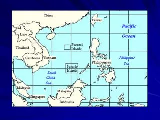
Kalayaan Islands Group • Presidential Decree No. 1596, Declaring Certain Area Part Of The Philippine Territory And Providing For Their Government And Administration (11 June 1978). • WHEREAS, by reason of their proximity the cluster of islands and islets in the South China Sea situated within the following: Kalayaan Islands Group are vital to the security and economic survival of the Philippines; • WHEREAS, much of the above area is part of the continental margin of the Philippine archipelago; • WHEREAS, these areas do not legally belong to any state or nation but, by reason of history, indispensable need, and effective occupation and control established in accordance with the international law, such areas must now deemed to belong and subject to the sovereignty of the Philippines; • WHEREAS, while other states have laid claims to some of these areas, their claims have lapsed by abandonment and can not prevail over that of the Philippines on legal, historical, and equitable grounds