Download
1 / 19
220 likes | 636 Vues
4 th grade Alabama History Chapter 1 Lesson 1. Discover Alabama. Objectives. Social Studies 1. Identify historical and current economic, political, and geographic information about Alabama on thematic maps .

E N D
4th grade Alabama History Chapter 1 Lesson 1 Discover Alabama
Objectives Social Studies 1. Identify historical and current economic, political, and geographic information about Alabama on thematic maps. 4. Describe the relationship of five geographical regions of Alabama to the movement of Alabama settlers during the early nineteenth century. ●Describe natural resources of Alabama
Outcome Use different maps to locate the state of Alabama and name its border states. Identify the five major geographic provinces of Alabama and list characteristics of each. *****Students should complete the left side of the anticipation guide before this lesson.
Think, Turn, and Talk (before) Think about how cameras can be far away from an area but can zoom in and appear to be close to an object. Imagine a camera form outer space zooming in to take a picture of you right now. Think about the different levels the camera would have to zoom past…Planet, hemisphere, continent, country, region, state, county, city, street. Can you specifically name each? You have 1min. to think. TURN and Talk to your partner and share your thinking
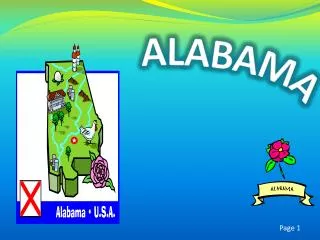
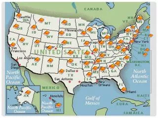
Where in the world is Alabama? Alabama
A Closer Look… States that border Alabama: Florida (FL) Georgia(GA) Tennessee (TN) Mississippi (MS) Alabama
What hemisphere do we live in? www.http://chalk.richmond.edu/education/projects/webunits/geography/hemispheres.htm • Click on the link above to learn about hemispheres. • Alabama is located in the Northern and Western Hemispheres
Five Major Geographic Provinces • Highland Rim • Cumberland Plateau • Ridge and Valley • Piedmont • Coastal Plain
Think, Turn, and Talk (During) After discussing the last map of Alabama and its 5 provinces, which province do you think Alabama is located in? You have 1min. to think. TURN and Talk to your partner and share your thinking.
Highland Rim • northwestern corner of Alabama • this land is in the Tennessee River valley • farms grow corn, cotton, and hay in this area. • level plains of fertile soil and gently rolling hills. • The states first inhabitants (people living in a particular place) probably came into north Alabama along the Tennessee River in this area. Charcoal from ancient campsites found in the region has been carbon dated back to more than 10,000 years ago.
Cumberland Plateau • Steep canyons that are home to some cool-weather plants and trees that do not grow anywhere else in the state. • Cumberland Plateau lies to the northwest of the Appalachian Ridge and Valley region. Compass Rose
Ridge and Valley • Lies below Cumberland and includes Birmingham and Red Mountain. • This region is comprised of sandstone ridges and fertile limestone valleys • three ingredients for steel manufacture, coal, iron ore, and limestone are found in abundance in this area and exposed from years of erosion (the wearing away of land by weather over a period of time) • Birmingham is one of the steel industry capitals of the world.
Piedmont • Piedmont means “foot of the mountains” in French • located in the eastern central section of Alabama(east of Birmingham) • consists of low hills, ridges, and sandy valleys • Coal, iron ore, limestone, and marble are found in this area of Alabama along with Cheaha Mountain, Alabama's highest point
Coastal Plains • Coastal Plain covers more than half the state. • Border between the Piedmont and the Coastal Plain is called the fall line. • Divided into the Upper and Lower Coastal Plain Provinces. • Upper Coastal Plains has a band of rich, dark soil known as the Black Belt. (one of the best places in the state to grow cotton. • Lower Coastal Plain reaches from the Black Belt to the Gulf of Mexico. • Lower Coastal Plains covered with longleaf pine, the state tree. Timber is one of the main crops of this area
Black Belt and Fall Line The border between the Piedmont and the Coastal Plains is called the fall line. Rivers and streams cross from higher land onto the flatter plains, creating the waterfalls and rapids that give the fall line its name. A band of rich, dark soil that runs across Alabama is known as the Black Belt.
Outcome Use different maps to locate the state of Alabama and name its border states. Identify the five major geographic provinces of Alabama and list characteristics of each. *****Students should complete the right side of the anticipation guide before this lesson. If your thinking has changed, briefly explain your thinking out to the side.
What did you learn? • How many geographic regions are there in Alabama? Name the regions. • What does the word Piedmont mean? • In what geographic province is the Black Belt? • What is the fall line? • Saraland is located in which geographic province? • Name the states that border Alabama. • What hemisphere do we live in?
Activity You will receive a blank map of Alabama. The state will be divided into the 5 different regions. Along with what you have learned in this presentation, you may also use your textbook (ch1lesson1) to do the following: • Draw and label the Fall line • Shade each land region in the following colors: coastal plain, piedmont, ridge and valley, cumberland plateau, highland rim • On the back, list all 5 provinces and give one important fact you learned about each province.