Download
1 / 14
170 likes | 472 Vues
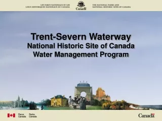
Trent-Severn Waterway National Historic Site of Canada Water Management Program. Trent and Severn Watersheds. The outlet of the Severn River at Lock 45 in Port Severn. The outlet of the Trent River at Lock 1 in Trenton. Water Management Program Priorities. Public Health and Safety.

E N D
Trent-Severn WaterwayNational Historic Site of CanadaWater Management Program
The outlet of the Severn River at Lock 45 in Port Severn The outlet of the Trent River at Lock 1 in Trenton
Water Management Program Priorities Public Health and Safety Navigation Mandate along the Canal System Green Energy Environment (Wildlife and the Fishery) Appropriate Water Levels and Flows for other uses
Competing Interests • In the event of wet conditions: • Public Safety can be endangered with increased water levels/flows. • Resulting high flows can disrupt navigation along the waterway. • High flows allow fish to spawn in elevated areas prone to declines. • Excess spill at many hydro generating stations.
Competing Interests • In the event of dry conditions: • Public Health is not initially endangered, water quality. • Navigation can be threatened as lake levels decline • Fish spawn in shallow areas are in danger of being left dry. • Reservoir lake levels drop more than normal. • Hydro generation is diminished as water flow is reduced.
Annual Cycle of Operation – Reservoir Lakes • Set winter stoplog settings at most dams. • Use snow survey results and other data to show whether early refilling is necessary. • Monitor the spring rise of the lakes and adjust the dams accordingly. • Aim to have the lakes full by the end of Spring. • Draw water according to the need for navigation (equal percentage basis). A computer model is utilized to aid this process. • Set the dams to their winter settings in the fall.
Annual Cycle of Operation - Kawartha Lakes • Draw down on the larger lakes commences January 1. • Snow surveys are conducted weekly. • Mid February decision point. • Spring Freshet begins, lakes are refilled with snowmelt and rainfall. • Try to maintain minimum flows in the Spring for the walleye spawn. • Lake levels must be maintained using water from the reservoirs. • After navigation, most smaller lakes are lowered in preparation for winter.
Data Collection • Level gauges on the Kawartha Lakes, Haliburton Reservoirs, and the Severn River system • 100 Manual Level Gauges (weekly/daily readings) • 50 Automatic Level Gauges (daily readings) • 12 Flow Gauges: rated level gauges, flow meters • 11 Rainfall Accumulation Gauges
Snow Surveys • Snow survey sites are laid out throughout the watershed to better anticipate the magnitude of spring melt water. Sampling tube is forced into the snow pack to measure depth Sampling tube is weighed to determine moisture content
Flooding…A Natural Event Dam at Lakefield: dams are wide open to pass high spring flows. Upper Otonabee River: Frazil ice blocking the flow of the river causing flooding downstream of Peterborough.
Flooding…A Natural Event Healey Falls Dam: Extremely fast melt coupled with above average snowfall accumulation. Lock 1 at Trenton: Sudden heavy rains and warm weather cause localized flooding.
Some Program Challenges Natural restrictions that impede flow Intense rainfall and snowmelt near Furnace Falls Log lifter and manual winches can slow response time
Summary • The Trent-Severn Waterway NHSC: • Considers the interests and needs of all stakeholders. • Manages water levels/flows based on an annual cycle of operation and current conditions. It is important to understand that Mother Nature drives the Water Management Program on the TSW. We do our best to steer it but sometimes She has other ideas.