Download
1 / 37
370 likes | 489 Vues
The European Union Strategy for the Danube Region and Romanian Scientific Community.

E N D
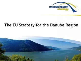
The European Union Strategy for the Danube Region and Romanian Scientific Community
The Danube River is the largest river in the EU (~2 850 km in length); its drainage basin (~817.000 km2) is shared by eight EU countries (Germany, Austria, Hungary, Czech Republic, Slovak Republic, Slovenia, Bulgaria and Romania) and six non-EU countries (Croatia, Serbia, Bosnia and Herzegovina, Montenegro, Ukraine and Moldova) with a population over 115 million . The region is facing numerous problems as: environmental threats, insufficient energy and transport connections, uneven socio-economic development as well as some life safety and security problems.
The Danube River is part of the largest river – delta – sea system of European Union. The other two components of the system are: • The Danube Delta (~5 800 km2) shared by Romania (~80%) and Ukraine (~20%) • The Black Sea (~420.000 km2) with six riparian countries: Bulgaria, Romania, Ukraine, Russian Federation, Georgia and Turkey • The three components of the system (the Danube River, the Danube Delta and the Black Sea) strongly interact and influence each other Ukraine Russian Fed. Romania Black Sea Bulgaria Georgia Turkey
The European UnionStrategy for the Danube Region (EUSDR) was launched in June 2011. It aims to implement an integrative policy in the region and to enhance cross-border cooperation for achieving a real sustainability. • The main objectives of EUSDR are: (1) connectivity; (2) protecting the environment; (3) building prosperity; and (4) strengthening the Danube Region. • The EUSDR comprises 11 Priority Areas: • To improve mobility and intermodality * • To encourage more sustainable energy • To promote culture and tourism, people to people contacts* • To restore and maintain the quality of water • To manage environmental risks* • To preserve biodiversity, landscapes and the quality of air and soils • To develop the knowledge society • To support the competitiveness of enterprises • To invest in people and skills • To step up institutional capacity and cooperation and • To work together to tackle security and organised crime.
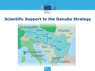
The Scientific Support to the EUSDR, as it was defined by JRC, focuses on: • Environmental protection: climate changes and consequences on ecosystems state, anthropogenic activities and their impact on environment; degradation of biodiversity and deforestation, major floods etc.; • Water use and agriculture development: In compliance with the EU Common Agricultural Policy (CAP) there are needs (1) to develop models of integrated landscape management of the river basin and sustainable land use balancing socio-economic development and protection of nature and (2) to establish a water abstraction management concept with special attention to water demand management using new efficient and sustainable water saving irrigation techniques. • Navigability: Development of new and more sustainable waterway management policies as the Danube River is a major inland waterway from the Black Sea to the North Sea (the 7th transport corridor). • Energy production: Extensive and sustainable use of renewable energies, including the bioenergy, according to the huge natural potential of the Danube Region. Establishment of a common energy market.
International conventions and organisations • in charge with the environmental and sustainable management of the Danube River – Danube Delta – Black Sea System (1) • The Danube River • Environmental protection • 1985 - the Bucharest Declaration on Water Management of the Danube River. • 1991 - the Danube River Protection Convention (DRPC). The DRPC and the Water Framework Directive (WFD) of the EU became the major legal instrument for cooperative cross-boundary water management in the Danube Basin. The DRPC came into force in October, 1998. • 1991 - the Environmental Programme for the Danube Basin (EPDRB). • 1991 - the Integrated River Basin Management (IRBM) in the Danube. • 1998 - the International Commission for the Protection of the Danube River (ICPDR) was established for implementing the stipulations of DRPC, and EPDRB as well as to ensure the sustainable and equitable management of water resources in the Danube Basin. • 2007 – the European Floods Directive – integrated flood management.
International conventions and organisations (2) • The Danube River • Navigation • 1856 - The Danube River European Commission was established for ensuring and improving international navigation on the lower reaches of the river and the general socio-economic development of the region. • 1938 - the Administration of the Lower Danube, under the coordination and control of Romania. The Administration was closed in 1940 according to the so called “Vienna Agreement”. • 1948 - the International Convention of navigation on the Danube River, signed in Belgrade. • 1954 - the Intergovernmental Danube Commission was established in Budapest, Hungary. The Intergovernmental Danube Commission is in charge with ensuring optimal conditions for international navigation on the Danube River. One of the operational units of the Commission is the Fluvial Administration of the Lower Danube located in Galati, Romania.
International conventions and organisations (3) • The Danube Delta • 1990 - the Danube Delta Biosphere Reserve (DDBR) and the Danube Delta Biosphere Reserve Authority (DDBRA) were established in Tulcea under the coordination of the Romanian Ministry of Environment. • 1998 - the Danube Biosphere Reserve for the Ukrainian part of the delta (Kilia Delta) was established in Vylkovo under the coordination of the National Academy of Sciences of Ukraine. • The Black Sea • 1992 - The Convention on the Protection of the Black Sea against Pollution (Bucharest Convention). Ratified in the 1994. • 1996 - the Strategic Action Plan for the Environmental Protection and Rehabilitation of the Black Sea . Updated in 2002 and 2009. • 2004 - the Commission on the Protection of the Black Sea Against Pollution (the Black Sea Commission or BSC) with its Permanent Secretariat were established as intergovernmental bodys of coordination.
Romanian projects to support EU Strategy for Danube Region • 1. Short and medium term projects • 1.A - Global Change Atlas of the EU Strategy for the Danube Region – a tool for the stakeholders in the decision-making process. • The project is proposed by the Institute of Geography of Romanian Academy in collaboration with the Ludwig-Maximilians University, Munich Main objectives: • The Atlas will reflect the current and future situation of the Danube Basin within a global change perspective • The Atlas will be a tool for decision makers from Danube countries to respond to the challenges of a changing environment • The Atlas will be a product responsive to the local, national and regional stakeholders’ requirements and to assure visibility of the Strategy • It will contribute to clearly distinguish the threats and opportunities for the development of the Danube Region community • The Atlas will identify critical areas in terms of environmental degradation, industrial decline, poverty and conflicts
Short and medium term projects (2) • 1 B. Sturgeon conservation in the Danube River Basin – a complex environmental-economic-social approach • Project proposed by the Institute of Biology of Romanian Academyin collaboration with an international consortium • Main objectives : • The assessment of health status for habitat and biota in the Middle and Lower Danube (focus on fish species / and especially sturgeons and their food resources) • Identification of key habitats for sturgeons and commercially important fish species and enhancement of their conservation status • Evaluation of potential economic damage of invasive alien species on sturgeon and commercial fishery and measures for ecological control of the selected alien species • Promotion of sustainable fishery and non-destructive caviar production by introducing „green labelling” • Ecological education and promotion of green tourism; identification of alternative income sources for local communities; awareness raising regarding the need to conserve the biodiversity of the Danube River Basin
Short and medium term projects (3) • 1.C. Aquatic Biodiversity Station in Sulina – Danube Delta • Project proposed by the Institute of Biology of Romanian Academy • 1.D.Danube River Research and Management - DREAM • Project proposed by BOKU Vienna, Austria, in collaboration with the University of Civil Engineering of Bucharest, National Institute of Marine Geology and Geo-ecology - GeoEcoMar in Romania and other institutes and universities from all Danube riparian countries. • Main objectives: • Construction oftwo large Responsible River Modelling Centers/hydraulic and environmental engineering laboratories (5000 l/s flow capacity) • Formation of acluster of river engineering simulation tools • Establishment of anetwork of field study sites along the Danube River and tributaries • Construction andoperation of aresearch vessel with diving shaft • Establishment of anetwork of existing and extendedDanube River Research Institutions
2. Long term projects 2.1 Danube International Centre for Advanced Studies in the River – Delta – Sea systems Case study:Danube River – Danube Delta – Black Sea System a Pan-European Research Infrastructure The Danube International Centre will answer to the: To Priority Areas of the E.U. Strategy for the Danube Region as: • The Priority Area 7 - Specific Action of the Danube Strategic Action Plan already mentioned: “To strengthen the capacities of research infrastructure: To establish joint international research centres for advanced studies” - a project proposed by Romania focusing the Danube River and the Danube Delta. • Connecting the Danube Region (added value – interconnection with ALL Europe); • Protecting the Environment in the Danube Region; • Building prosperity in the Danube Region; • Strengthening the Danube Region To Europe 2020 strategy – all 5 major goals (employment, innovation, education, poverty reduction and climate/energy)
The Danube International Centre for Advanced Studies for Rivers – Deltas – Seas Will represent a new Pan-European Research Infrastructure that would gather and integrate excellent expertise and facilities in Europe; Will represent the needed HUB for a new European focus to characterize a complex river-delta-sea system of continental importance (Danube – Black Sea) and interconnect other centres dealing with less complex systems around Europe (NODES) The Danube International Centre for Advanced Studies for Rivers – Deltas – Seaswould provide excellent accessibility to the most important and true Natural Laboratory in Europe : Lower Danube – Danube Delta – Black Sea.
The Danube International Centre for Advanced Studies for Rivers – Deltas – Seas is not only the solution to European political priorities – but also a needed and agreed research infrastructure from an ever increasing number of EU universities and R&D institutions
“The actors” Initiative Present (Near) Future
“The actors” (institutions) InitiativePresent
Major goals • To improve the sustainable, innovative and adaptable management of wetlands, deltas, lagoons and coastal ecosystems by studying in deep the processes influencing the evolution environmental state of the River – Delta – Sea systems • To increase the involvement of local communities in the sustainable management of wetlands • To develop knowledge based economy to support the economic growth of Danube – Danube Delta – Black Sea region without disturbing its natural biodiversity
Scientific mission Assessing the river-delta-sea macrosystems` characteristics and reference state of environment Global climate changes and related consequences for river-delta-sea macrosystems Ecosystem response to climate change Effects of increasing human activities on river-delta-sea macrosystems Changes in Societal Demand on river-delta-sea macrosystems
Scientific domains Life sciences: -Ecosystem assessment and monitoring; restoration strategies, nature conservation, modelling, simulation and hypothesis testing etc. Earth sciences: Origin & evolution of D-DD-BS system; geodynamic processes; oceanography, hydrology and sedimentology; geo-hazards and risk assessment; modelling regional impact of climate change etc. Socio-economic sciences: - Assessing the changes in society demand; natural resources assessment and valuation; anthropogenic impact on ecosystems goods and services; development scenarios and measures for sustainable use
Additional issues • A. Permanent education – common international programmes will contribute to harmonising teaching systems across the D-DD-BS region; the ecological education will increase awareness on the environmental values and the need to preserve it • B. Environmental laws and regulations – provides tools for the implementation of EU policy for environmental protection • C. Green products and technologies – focus on the valorisation of natural resources in the D-DD-BS system according to the sustainability principles • D. Impetus for new R&D technologies and equipments and ICT
Distributed Research Infrastructure Riparian Responses Node Node Hub (Danube Delta) Node Node Catchment forcing Node Node Remote Sensing (Example of connecting hub and nodes in function of request)
Location of the Danube International Centre for Advanced Studies on River – Delta – Sea Systems Kilia Danube Delta Sulina Tulcea Sulina St.George International Centre Murighiol
WHY DANUBE DELTA? • Position: interface between the Danube River (the most international river in the world, over 2 800km in length) and the Black Sea • Unique place: • the largest delta of the European Union (~6 000 km2) • less affected by human activities • high biodiversity (over 30 types of ecosystems) • Conservation status: • Ramsar site (1991) • Biosphere Reserve • UNESCO MAB Program • UNESCO World Heritage site site
WHY MURIGHIOL? Location: placed on the Danube River (St. George arm, within the Danube Delta Biosphere Reserve, the location was selected from 11 sites) Access facilities: by road and by the Danube River, immediate access to the Danube Delta, access to the coastal zone and to the Danube River. Land availability: Murighiol Local Council approved about 10 hectares area for the Centre
Other already existing major facilities that will be used by the Centre since the beginning R/V “Mare Nigrum” – 3 000 tdw R/V “Istros” – for river and coastal sea research Laboratory boat “Halmyris” for the Danube Delta research
Principles of Centre’s functioning as Pan-European distributed Research Infrastructure • The Centre will: • become an ERIC (European Research Infrastructure Consortium) from the legal point of view • have an international management • have an International Scientific Board • have an International General Council with participation of Stakeholders and NGO-s The Danube International Centre for Advanced Studies on River – Delta – Sea Systems: case study the Danube River – Danube Delta – Black Sea System is considered by the Romanian Government as a project of national priority
Short term plan (end of 2013 - 2014) Final Version of the White Book – a scientific and structural Framework Programme of the Centre Drilling referenceborehole (100 m depth) inside Murighiol Centre location Designing, obtaining official approvals and starting works on building No.1 of the Centre 2014 – application of the Danube International Centre as ESFRI ENV Pan-European Distributed Research Infrastructure
Mid-term plan 2014 – 2020 (structural funds - construction) Construction Phase 1 – late 2014 – 2015 Basic constructions – to add to already existing facilities and infrastructures from other partner countries Buildings for field research activities on the river – delta – sea system Administrative building of the Centre and office building for scientists Main logistics
Mid-term plan 2014 – 2020 (structural funds - construction) Construction Phase 2 – 2016 – 2017 • Specialized high-tech laboratories – as agreed in the ESFRI Proposal Phase 3 – 2018 – 2020 • Specialized high-tech laboratories – as agreed and resulted from the Preparatory Phase. • Research Vessels to replace existing fleet for studying the river, delta and sea
2. Long term projects • 2.2. MARINEGEOHAZARDS - Black Sea Early-Warning System • Romania-Bulgaria cross-border project with four participating institutes: • from Romania: the National Institute of Marine Geology and Geo-ecology – GeoEcoMar and the National Institute of Earth Physics; • from Bulgaria: the Institute of Oceanology – Varna and the Geological Institute - Sophia, both from the Bulgarian Academy of Sciences • The Black Sea Early-Warning System – MARINEGEOHAZARDS will be composed of two networks forming sub-systems: • The EUXINUS network - the Black Sea regional early warning system to marine-geohazards • The GeoPontica - the first on-line geodynamic surveillance network in the entire Black Sea region
1. The EUXINUS network - the Black Sea regional early warning system to marine-geohazards • Components of the EUXINUS cross-border infrastructure : • Network of 5 complex, fully automatic marine stations (buoys) with automatic equipment for measuring the characteristics and the dynamics of water masses . • Interconnected, national co-ordination Centres, located in Constanta, Romania and Varna, Bulgaria. The Centres will be provided with common decision support software and technical means to evaluate and forecast marine geo-hazards
The EUXINUS network - the Black Sea regional early warning system to marine-geohazards (continuation) • Regional capability for marine seismic monitoring and surveillance comprising: • - real-time on-shore equipment (3 marine seisimicity monitoring systems, 1 coastal gauge, 5 strong motion seismometers and 5 extensometers); • - specialized seismic devices operated from the Romanian R/V Mare Nigrum and the Bulgarian R/V Akademic (7 Ocean Bottom Seismometers and 1 Marine seismic acquisition system)
2. The GeoPontica network - the first on-line geodynamic surveillance network in the entire Black Sea region • The GeoPontica network will include: • 18 on-line geodynamic stations located along the Romanian-Bulgarian coast; • - 2 coordination Centres located in Constanta, Romania and Varna, Bulgaria
With GeoPontica, the MARINEGEOHAZARD project is setting up a cross-border infrastructure that will establish an unitary reference system based on information from the geodetic networks and the tide-gauges in Dobrogea – Romania and Bulgaria. • Based on ETRS (EU Terrestrial Reference System) and EUVN (EU Vertical Reference Network), GeoPontica will provide information on: • Vertical movements of the Earth crust as isostasy, epeirogenetic up-lift, subsidence, sediment compaction; • Horizontal movements of the Earth crust due to global tectonics (motion of the lithosphere plates) or relative movements of tectonic blocks; • Changes of the mean sea level position.
The Marine-geohazards project will enter from the beginning major EU Observing Systems and ESFRI projects: • LIFE WATCH - Science and technology infrastructure for biodiversity data and observatories • European Plate Observing System (EPOS) - Research Infrastructure and e-Science for Data and Observatories on Earthquakes, Volcanoes, Surface Dynamics and Tectonics. • EURO-ARGO Research infrastructure for ocean science and observations • EMSO European multidisciplinary seafloor observation infrastructure • GOOS – Global Ocean Observing System, specifically Black Sea GOOS, and EOS – Earth Observing System