1.5 waves
1.5 waves. Understand how. ocean. and. currents. change. the. face. o f. coastal. ar e as. (Chapt e r. 3). 1. Hydraulic Action/Pressure - air being fo r ced into c rack in roc k s. 2. •. Corrosion (Solut i on)

1.5 waves
E N D
Presentation Transcript
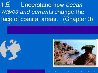
1.5 waves Understandhow ocean and currents change the face of coastal areas. (Chapter 3)
1. HydraulicAction/Pressure- airbeingforcedinto crackin rocks. 2. • Corrosion(Solution) Mineralssuch ascalcium carbonate & limestone dissolvein thewater 3. • Abrasion rock& sand particles suspended in the water bump,grind,scrape& gouge surfaces thewaterhits
Hydraulic Action • Hydraulicactionisaformofmechanicalweathering • Causedbytheforceofmovingwatercurrentsrushing intoacrackintherockface. • Thewatercompressestheairinthecrack,pushing rightto the back. it • Asthewaveretreats,thehighlypressurizedairis suddenlyreleasedwithexplosiveforce • Capableofchippingawaytherockfaceovertime.
Hydraulic Action
Emerging vs. SubmergingCoastlines • • Emerging Causedby lowering water levels and/orrising land level • • Submerging CausedbyRISINGsea levels Wereoncerivervalleys now submerged Resultsin moresand fromdeltasand/or outwashplains Lower,gradualslope • • Land“springing afterglacieris gone. up • • Steepland features,cliffsetc. •
Define the terms bay bay spit beach bar • • • • (P. 44-45)
Bay Beach • Smallbeachof sandfound betweentwo peninsulasor headlands Anaccumulation ofsediment depositedby wavesand longshoredrift alongabay. •
Bay Beach – Bonne Bay
Bay Beach
Spit • Ridgeof sandprojecting fromthelandintoabody ofwater usuallywithacurved seawardend. Spitgrowsinthe prevailingdirectionof longshoredrift. Endsarecurvedbythe actionofwavesin differentdirections • • •
Spit • Whatcanyoutell aboutthe directionoflong shoredrift? • Isthereany indicationabay barmightform? • SandyPoint Newfoundland!
Spit - California
Bay Bar • Aridgeof mud,sandor siltextendingacross bay. Formedwhenspits stretchacrossthe mouthofthebay Noticethespithas closedoffthemouth a • • of the harbor/bay Wouldthesebeatourist attractionordistraction? •
Bay Bar
Bay Beach 1. Wheredoesall thebeachsand comefrom? Can youproposetwo sources? 2. The pointof land on topof the picture wouldbe called?
Define the terms bay bay spit beach bar • • • • Are these landforms caused erosion by or (P. 44-45) weathering?
Describe how sea caves,seaarches andseastacks are formed. (P. • 48) Thesethree coastalstructures occuron“emerging” coast lineswithsteepcliffs&a headland. 1st 2nd 3rd • Sea cavesform, seaarchesformand seastacksform.
Describe how sea cavesare formed. (P. 48) • Wavesstrikethe headlandfirst. • Wavesrefractaround the headlandandput hydraulicpressureon thesidesofthe headland.
Describe how sea cavesare formed. (P. 48) • Thehydraulic pressureripsaway sectionsof weakenedrock. • Erosionoftheweak portionscreate caves& blowholes inthesidesofthe headland.
Describe how sea arches areformed. (P. 48) • Mostseaarchesare formedfromthewave erosionof wherethe twocaves aheadland backsof havemet andbrokenthrough. acompletepassage wayortunnelor “arch”throughthe headland!! •
• Itisdifficulttosee orimaginefrom the top view. • Howevertheside viewprovidesa betterpicture.
SeaArch Parson’sPond, NorthernPen., NL
Sea Stack • Isolatedpillar ofrockthathas separatedfromaheadlandby erosion. become coastal • Itisusuallyformedbythecollapseofan arch. Furthererosionwillreduceittoastump, whichisexposedonlyatlow tide. •
Describe howseastacks areformed. (P.48) Continuous • erosioncauses the collapseof theground overthearch. Thisleavesa pillaror column or “STACK”of land standingalonewherethe headlandwas. •Seastacksarecommonineastern Canada. •Manyhaveplantgrowth on top. •
Analyzethe processesthat resultin the straightening [submerged] out” of an irregular coastline. (P. 43) 1. Weathering Headland What forces causethe of 2. Transportation ofsilt 3. Depositionofsilt Wheredoes depositionoccur? Baybeaches; filling inlets Baybars;closing offinlets Howis silt • transported? LongshoreDrift Waves Currents weathering erosion? Hydraulic Corrosive Abrasive & • • • 4.Summary:Submerged coasts straightenduetoweathering Anderosion.
Analyze straightening the processesthat resultin the out” of an irregular [emerging] coastline. (P. 48) • Emergingcoastlinesstraighteninmuch submergingcoastlines. thesamefashionas • WeatheringandErosionofheadlandscreates seacaves,sea archesandsea stacksinsteadofbaybeaches,spits&bay bars. Howevertheresultis similarinthatheadlandsare reducedinsize.
the protrusions of land that extend the farthest out into wave action. The Headland of the Eastport Peninsula at Salvage Headlands:
waves bending around headlands as they hit the shallow water by shore Wave Refraction:
emerging coastlines straighten in much the same fashion as erosion of headlands creates sea caves, sea arches and sea stacks instead of bay beaches, spits and bay bars; however the result is similar in that headlands are reduced in size which straightens the coastline. Compare the headland length in figure 3.11 before and after erosion. submerging coastlines; Straightening of Emerging Coastlines
In this lesson you will: 1.9.1 Examine examples to illustrate how human activity adapts to land forms and water forms. 1.9.2 Examine examples to illustrate how land forms and water forms affect accessibility. 1.9.3 Justify a preference for the appeal of selected landforms and water forms. 1.9.4 Propose a solution to a threat posed by selected land and water forms. Landforms Affect Human Activity
Humans have adapted to most conditions on earth. Look at many small fishing villages in Newfoundland and you will see how people adapted to build houses up cliffs that overhang the ocean. The stilt houses of Bangladesh show how humans have adapted to living in delta regions. Human adaptation
Assigned Readings "Storm surges in Bangladesh" on p. 50-51 in your text book.
In this lesson you will learn: To develop a proposal for the economic use of selected landforms or water forms. (i) Economic Proposal
You will be expected to write an economic proposal for a given land form or water form. You could be asked to write a proposal for a river with many large water falls or with small rapids; you could be asked to write a proposal for a mountain near the coast. Economic Proposal
The economic activity must fit the terrain. For example a hydroelectric generating station on a slow meandering old river might not be a good idea whereas boat tours might be. How would the environment be impacted? Obviously you would need an environmental impact study and a means of reducing the impact on nature. Is the area accessible to people or machinery? You must be able to access it to make money. How might building and erosion forces impact your proposal in the short term and long term? What types of potential problems accompany the land or water form. For example flooding accompanies old meandering rivers. Consider the following when you do a proposal