Coastal Processes
Coastal Processes. Lesson 1. Lesson aims: What is the coast? What is meant by a coastal system? What are the inputs, processes and outputs of a coastal system?. Key Question 1:. What is a coastal system and what are the dynamics of coastal environments? The Coastal System


Coastal Processes
E N D
Presentation Transcript
Lesson 1 Lesson aims: • What is the coast? • What is meant by a coastal system? • What are the inputs, processes and outputs of a coastal system?
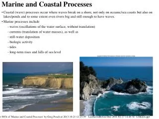
Key Question 1: What is a coastal system and what are the dynamics of coastal environments? The Coastal System • The coast is the interface between land and sea. One way to study the coast is to view it as a system. The coast is an open system. Energy inputs from waves drive the system.
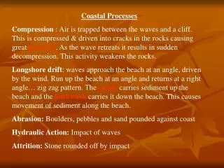
From time to time the energy input is boosted by storm surges and tidal waves. • A small proportion of the sediment is provided from within the system by wave erosion of cliffs. • Weathering also contributes; cliff faces above the high water mark are affected and any loose materials broken off either fall or are carried within reach of the waves by different types of mass movement. • The evidence for this interaction are the processes of erosion, transport and deposition. These processes give rise to the system’s main output: coastal landforms such as cliffs, beaches and salt marshes.
What is a system? • It is where a set of components or variables operate together. • They interact with one another. These are the processes. • Patterns and landforms results from the interactions And can be observed and classified. These are the outputs.
Lesson 2 Lesson aims: • What is longshore drift? • What is meant by swash and backwash? • What are coastal sediment cells? • The names of the coastal sediment cells in the UK.
Longshore drift • Where waves approach the coastline at an angle, when they break their swash pushes beach material up the beach at the same angle. The backwash then drags the material down the beach perpendicular (at a 90º angle) to the shore, following the line of the steepest gradient. This produces a zig-zag movement of sediment along the beach known as longshore drift. The action of waves constantly moves and sorts different sized material beach material..The action of longshore drift sorts beach material, due to the amount of energy required to move sediments. Larger particles will need more energy and therefore move at a slower pace. Largest beach sediment is found updrift, and the smallest material, which is more easily moved, downdrift.
Coastal Sediment Cells • Longshoredrift is responsible for most of the interaction within the system through transfers of sediment. Loose materials are relocated within the system through transfers of sediment. Loose materials are relocated from sections of coastline dominated by erosion to those where deposition occurs to form constructive landforms such as beaches, spits and bars. Winds can carry sand inland as an output from the coastal system. Deposited coastal sediments that remain in position for a considerable length of time are colonised by seral communities as part of a plant succession.
Questions • Describe and explain longshore drift. • Draw a sketch of the longshore drift process. • What is swash? • What is backwash? • What are coastal sediment cells? • Name the coasts that join the sediment cells in the UK. You could set it out like this…
Equilibrium beach profile Energy input (swash) equals energy output (backwash): no net sediment transport Anticyclone conditions – reduction in wave energy As beach profile steepens, backwash strength increases Low energy surging breakers give a net onshore movement of sediment Beach profile steepens
Lesson 3: Wave types and characteristics • What are the characteristics of waves? • How are they formed? • What is swash/backwash? • What are destructive waves? • What are constructive waves?
Wave types • Waves are undulations of the water surface caused by winds blowing across the sea. They consist of orbital movements of water molecules which diminish with depth. • The circular motion of waves at the surface is copied below in a series of circles which become smaller with increasing depth. • Shallow water interferes with the circular movements below the surface, which are slowed down by the friction of the sea bed. The result is that the length of the wave shortens and the front of the wave steepens. • The speed of flow of water at the top of the wave begins to exceed that of the rest of the wave below so it topples over and the wave breaks.
What determines wave type? Fetch, wind direction and wind strength are the main factors determining the height and energy of breaking waves. Fetch is the distance of uninterrupted water surface over which the wind has blown to form the waves. The longer the length of open water over which the winds travel, the longer the fetch and the greater the amount of energy released when waves break in the coastal zone.
How do waves form? • The great majority of large breakers one sees on an ocean beach result from distant winds. Four factors influence the formation of wind waves: • wind speed, • distance of open water that the wind has blown over — called fetch, • time duration the wind has blown over a given area, • water depth.
Wave Characteristics • Wavelength (L) is the average distance between successive wave crests. • Wave height (H) is the vertical distance between a wave trough and a wave crest. • Wave steepness is the ratio of wave height to wavelength. Powerful waves are steep because they are high and have short wavelengths. • The energy in a wave is equal to the square of its height. Thus a wave that is two metres high contains four times as much energy as a one-metre high wave.
Lesson 4: Lesson aims • Classifying waves (learning the two types of wave) Destructive and Constructive waves and their resultant beach profiles. • Tides and how they affect the coastline compared to waves. • Coastal winds in Britain.
How do waves form? • The great majority of large breakers one sees on an ocean beach result from distant winds. Four factors influence the formation of wind waves: • wind speed, • distance of open water that the wind has blown over — called fetch, • time duration the wind has blown over a given area, • water depth.
Classifying waves • A common classification for waves is into destructive (plunging breakers) and constructive (spilling breakers), although not all waves are as easy to distinguish as this simple classification suggests
A destructive wave • All the energy accumulated by movement is released when the wave breaks. Since destructive waves are high and short, there is a sudden impact of water upon whatever the breaking wave hits. These waves are sufficiently high for the water motion to be almost circular so that the great force of water is directed downwards when they break. This gives a strong backwash, which increases the likelihood of loose material being clawed back down the beach into the sea. • The rapid sequence of breaking waves under storm conditions means that the new swash is running into the backwash from the next breaker, reducing further any chance of sediment deposition.
A constructive wave In contrast, the more elliptical shape of water movement in a constructive wave means that the forward movement of the breaking wave is more pronounced than its downward force. By breaking forwards a strong swash is pushed up the beach, while the energy of the backwash is reduced as water seeps into the sand and shingle. Not all the loads is carried back to the sea. This promotes deposition.
Lesson 5: Coastal winds in Britain • What are prevailing winds, where do they occur around the UK? • What are dominant winds, where do they occur around the UK? • Direction of longshore drift around the British Isles. • Factors leading to the creation of storm surges • High and low energy coasts in the British Isles
British coastal winds • Strong winds are one of the characteristics of the British Climate, because it lies in the zone dominated by low pressure and frontal depressions within the general world circulation. • There is a high incidence of storm and gale force winds all down the western side of the British Isles. • Storm waves generated by strong winds travel fast and follow in rapid succession, which contribute to their highly destructive nature.
Fetch in the British Isles • The maximum fetch in the British Isles is for Westerly winds blowing onshore on the west coast after an Atlantic crossing. Their fetch is longer than that can be reached by northerly or north-easterly winds in more enclosed seas like the North Sea. • The westerly winds are also the prevailing winds, the winds that blow with greatest frequency. • Where fetch is large, as along the west coast, the factors that control the height of breaking waves are wind strength and length of time it has been blowing at that strength.
What about the east coast? • The strong westerly winds cannot create damaging waves along the east coast of Britain because they are blowing offshore. • Dominant winds (winds that produce the largest waves along a coast) are more significant here. • The most damaging waves that affect eastern Scotland and England are driven by winds from the east and the north. • Being dominant as opposed to prevailing means that they exert control over wave size on a smaller number of occasions during the year.
Dominant winds • There is no land on the direct northerly route from east Anglia to the North Pole to interrupt movement; therefore northerly winds originating in the Arctic ocean can drive waves onto the exposed north coast of Norfolk with the second longest fetch in the British Isles. • In extreme circumstance, these produce tidal storm surges, which are short-term increases in sea level. They can be responsible for considerable changes to the coastline and great damage to property
Tides • Tides have a more regular energy input into the coastal system than do waves. Tidal fluctuations depend upon the positions of the moon and sun. • Tides can be forecast and are not an unpredictable input into the coastal system in the way that wind strength and wave size are. • However, for the low-lying coastal regions spring tides are a worry, but their time and height can be forecast and precautions taken.
What are high and low energy coasts? • High energy coasts are ones in which wave power is strong for a significant proportion of the year. The distribution of these coasts is largely controlled by the climate and direction they face. • Strong winds capable of generating the largest waves are more frequent in areas of the world with a Cool Temperate Western Maritime climate (CTWM). • High average wind speeds are associated with the frontal depressions which form over the oceans at the junction between warm tropical and cold polar air masses. • Exposed coastlines often experience gales, storm force winds regularly and hurricane force winds from time to time. The storm wave environments found in areas with CTWM climates are shown below. • They occupy similar positions on the western side of the continents between 45 and 65 degrees north and south of the equator. Wave height and energy are greater in the southern hemisphere as westerly winds, depressions and ocean currents (the Antarctic drift) have uninterrupted passages around the globe as so little land extends south of 45 degrees, Waves hitting Chile often have the world’s longest fetches.
High and low energy coasts in the UK. • Within the UK, the west coast is a higher energy coast than the east coast. Westerly is the direction of both prevailing and dominant wind direction; it is also the direction of longest fetch. Maximum wave heights decrease from west to east and from north to south across the British Isles away from exposure to the open ocean and onshore westerly winds. • Fetch is the limiting factor for the height of waves generated by easterly winds in the North Sea. No matter how long an easterly gale blows, the waves breaking against the eats coast can never reach the height of those from westerly gales along the west coast. • However, with waves of fifteen and more meters in height occasionally recorded along the coast of Holderness, waves still have the power to cause considerable erosion.
Wave energy differences on a smaller scale • On a smaller scale some estuaries, inlets and bays provide more sheltered environments in which the average wave energy is lower than on the headlands and the more exposed coastal zones are on both sides of them. A change in coastal direction can also reduce average energy levels. • Along coastlines that are irregular, waves approaching the headland feel the effects of frictional drag at their base before those which approach the bay. • Waves around the headland turn inwards and concentrate their attack on them. This bending of the waves around a headland so that they approach almost parallel to the coast is called wave refraction. • On the other hand, waves in the bays spread outwards and dissipate their energy. Differences in wave energy levels are thereby created at a local scale.
QUESTIONS: • What is meant by high energy coastlines? • What is wave refraction? • How can this affect wave energy? 4. Explain why ; i) the British Isles is an area of the world associated with high energy coasts ii) coasts with the highest energy are located on the western sides of the British Isles.
Questions • Distinguish between prevailing and dominant winds • Draw a wind rose to show these percentages • On an outline map of the British Isles, use annotations to outline the effects of relative frequencies in wind direction upon coastal processes around the British Isles. • Figure 1 shows longshore drift and general directions of movement around Britain. Explain what Figure 1 shows in relation to prevailing and dominant winds. 5. Why are tides considered to be less important than waves in the formation of coastal landforms? 6. Why do extreme events such as storm surges, only occur when a combination of factors favourable to their formation are present? 7. Explain why ; i) the British Isles is an area of the world associated with high energy coasts ii) coasts with the highest energy are located on the western sides of the British Isles.
Dynamic equilibrium in the coastal system • The concept of dynamic equilibrium is central to our understanding of natural systems. A system is in dynamic equilibrium when its inputs and outputs of energy and matter balance. In these circumstances, a system remains in steady state for long periods of time. Of course, short-term changes will still occur. Systems adjust to these changes by a process of negative feedback. Short-term event such as storms, greatly increase energy inputs to the coastal system. This starts the movement of sand and sediment transport comes to an end. At this stage the beach is at equilibrium – as long as wave conditions stay the same the basic beach form remains unaltered. • Landforms such as beaches can adjust to changing energy inputs in just a few hours. • In contrast, hard rock landforms, such as cliffs, may take thousands of years to achieve equilibrium. Today’s sea-level, and therefore the position of the coastline is only 6,000 years old. This means that large parts of the coastline have not had sufficient time to achieve equilibrium. We notice this by events such as rockfalls and landslides which can dramatically alter the coastline.
Why do some coastlines erode away? Why do some grow? All beaches exist in a dynamic equilibrium involving four factors: • The supply of sand • The energy of the waves • Changes in sea-level • The location of the shoreline It is the balance of these four factors and how they interact with each other that determines whether a beach erodes or grows.
The concept of equilibrium Coasts are dynamic and they change frequently. These changes are principally caused by changes in energy conditions such as wave energy e.g. Which may increase during storms. The morphology of the coast responds to changes in energy because it aims to exist in a state of equilibrium with the reigning processes. However, there are three types of equilibrium. 3. Steady state equilibrium. • This refers to a situation where variations in energy and the morphological response do not deviate too far from the long-term average. E.g. Along a coast that experiences relatively consistent wave energy conditions, the gradient of a beach may be steeper at certain times of the year and shallower at others but the average annual gradient is similar from year to year. 2. Meta-stable equilibrium • This exists where an environment switches from two or more states of equilibrium the switch stimulates by some sort of trigger. An example of this includes the action of high energy events such as storms/tsunamis. Which can very rapidly switch a coastal system from one state of equilibrium to another by removing or supplying large volumes of beach sediment for example. Also, human activity often has this effect on coastal environments. 3. Dynamic equilibrium • Like meta stable equilibrium, this too involves a change in equilibrium conditions but in a much more gradual manner. A good example is the response of coasts to the gradual rise in sea levels that were experienced through the twentieth century as a result of climate change.
Swash and backwash • When a wave breaks, water is washed up the beach: this is called the swash. Then the water runs back down the beach: this is called the backwash. With a constructive wave, the swash is stronger than the backwash. With a destructive wave, the backwash is stronger than the swash. • Simple summary: Large waves erodeand very small waves deposit.
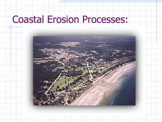
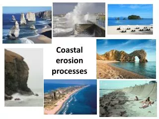
Lesson 7: Key question 2: What are the processes of coastal erosion and what are the resultant landforms? • What are the processes of coastal erosion? • What are the factors affecting the rates of erosion along a section of coastline?
So what’s the difference between Weathering and Erosion? • Weathering is the breaking down of rock into smaller and smaller particles. Weathering processes include frost wedging, acid rain dissolution, root growth, wind particle abrasion, heat expansion cracking, hydraulic fracture, and rock tumbling in rivers and streams. • Erosion is the movement of weathered material from one place to another place through the agents of erosion: wind, water, ice, and gravity. • In tandem, weathering and erosion act to lower the high points, and raise the low points on the surface of the planet.
Sub aerial processes • This literally means ‘those occurring at the base of the atmosphere’. • The effects of non-marine processes in the coast zone can be observed most clearly on cliff tops. The influence of sub-aerial processes such as mass movement and weathering is particularly evident on incoherent rocks. Heavy rainfall is the trigger for many movements. • In the UK most cliff tops are vegetation covered which delays but does not stop mass movements.
Processes of weathering Weathering is the decomposition of earth rocks, soils and their minerals through direct contact with the planet's atmosphere. Rocks gradually wear away. This is called weathering. There are three types of weathering: • physical weathering • chemical weathering • biological weathering Physical weathering • This is caused by physical changes such as changes in temperature, freezing and thawing, and the effects of wind, rain and waves. Temperature changes When a rock gets hot it expands a little, and when a rock gets cold it contracts a little. If a rock is heated and cooled many times, cracks form and pieces of rock fall away. This type of physical weathering happens a lot in deserts, because it is very hot during the day but very cold at night. Freeze-thaw Water expands slightly when it freezes into ice. This is why water pipes sometimes burst in the winter. You might have seen a demonstration of this sort of thing at school - a jar filled to the brim with water eventually shatters after it is put into a freezer. Biological weathering • Animals and plants can wear away rocks. This is called biological weathering. For example, burrowing animals such as rabbits can burrow into a crack in a rock, making it bigger and splitting the rock. Chemical weathering • Rainwater is naturally slightly acidic because carbon dioxide from the air dissolves in it. Minerals in rocks may react with the rainwater, causing the rock to be weathered. The weathering of rocks by chemicals is called chemical weathering.
Erosional Processes We have learned that different coastlines receive differing intensities wind and wave energy. The intensity and duration can often result in varied degrees of erosion on a coastline. The can be classified into types of erosion. Wave action on coastlines causes three types of erosional process: abrasion (also know as corrosion), hydraulic action and corrosion.,Cavitation is also believed to add to the pressures exerted on rock faces by breaking waves These processes are most effective when high energy waves associated with storm conditions, strike coasts made of less resistant rocks such as clay and shale.
Activities • Watch the animations and listen to discussion. • Complete a mind map of weathering and erosion at the coast.
Questions • a) Explain how the different processes of marine erosion operate. b) Describe and comment upon the effects of marine processes in image A and image B. c) Discuss the factors which lead to high rates of marine erosion along a coastline. 2. a) Define ‘sub-aerial processes’. b) Outline the nature of sub-aerial processes which operate in the coastal zone in the UK.
Lesson 9 • Mass Movement • What are the factors affecting the rates of erosion and therefore cliff profiles along a section of coastline? • What are wave cut platforms? • What are wave cut notches? • How do they form?
Mass movement • Mass movement is the down slope movement of earth materials under the influence of gravity. The detachment and movement of earth materials occurs if the stress imposed is greater than the strength of the material to hold it in place.
Processes of mass movement • Soil creep is taking place on even the gentlest of slopes, albeit slowly. • Slides occur from time to time on slopes where surface layers of grass and soil are thin. After periods of prolonged and heavy rainfall, when the ground has absorbed all the water it can take, the weight of the saturated soil becomes too great and it tears away the grass at the top of the slope. Once its hold upon the top of the slope is broke, the mass easily slides over the wet surface below, particularly where it overlies unconsolidated rocks such as boulder clay and glacial sands. • Slumping is another type of mass movement that occurs in the coast zone. Slumps are distinguished from slides by the element of rotation in the flow of the mass as it moves down a curves slip plane. Many slumps are triggered off by undercutting at the base of the cliffs, so that the mass becomes unsupported. Movement by the mass is encouraged by previous saturation from heavy rains creating a well-lubricated plane of movement.