Download
1 / 8
80 likes | 209 Vues
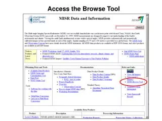
Access detailed orbit information and imagery using the Browse Tool. Select your region and desired time range to view orbit data and visualize crossing paths. Modify orbit or camera selections for tailored results. Discover true-color MISR imagery with a 2.2 km resolution, focusing on a specified day to examine map paths. Enhance your understanding of satellite data and imagery with user-friendly navigation tools designed for exploration and analysis.

E N D
Select the Region and Time Range Select to see Orbit Information
Orbit Information Change the orbit or camera selections and Show crossing paths Select to View the Image
Orbit Information and View the Image
MISR Imagery – Browse Tool true-color images, 2.2km resolution
Select day to view map