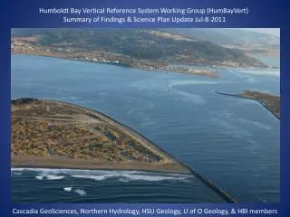
Humboldt Bay Vertical Reference System Working Group - Coastal Resilience Project
300 likes | 393 Vues
Join us in preserving Humboldt Bay ecosystems through accurate sea level measurements and tectonic modeling. Get involved in our partnership-based research initiative funded by NPLCC for a sustainable future.

Humboldt Bay Vertical Reference System Working Group - Coastal Resilience Project
E N D
Presentation Transcript
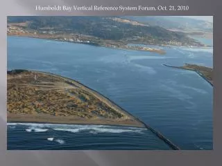
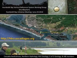
Humboldt Bay Vertical Reference System Working Group (HumBayVert) Humboldt Bay Initiative Meeting: June-24-2014 http://hbv.cascadiageo.org Cascadia GeoSciences, Northern Hydrology, HSU Geology, U of O Geology, & HBI members
Background • Partnerships • Issues • Goal • Funded by NPLCC • Update • 2013 Annual Report • Trinidad Tide Gage Installation • SLR Calculations • Next Step • Predictive Model • Tectonic Modeling • Need Funding
Partnerships • Cascadia GeoSciences • Humboldt Bay Initiative • “Our vision is a vibrant, thriving, and resilient Humboldt Bay Ecosystem that supports the well-being of our human and natural communities.” • North Pacific Landscape Conservation Cooperative • Dept. of Interior Climate Change • Adaptation Program
Issue: tectonics controls Local Sea Level Accurate measurement of local land elevation in the Humboldt Bay area Priority issue identified by USACE, Coastal Commission, NOAA NGS & others
Subduction Zone Earthquake Cycle and Vertical Land Level Changes: Interseismic between earthquakes Coseismic during earthquake Atwater & Satake, 2009
Compare Rates & Test Observations Compare to tide gage observations Compare to GPS and land level surveys Compare to long term ESLR
Historic Temporary Tide Gage Locations Humboldt Bay 1977-1980 Mad River Slough Samoa North Spit Fields Landing Hookton Slough
North Pacific Landscape Conservation Cooperative funded this research project through the USFWS, Award F11AC01092
Trinidad Tide Gage • We are purchasing equipment that will be installed and maintained by CenCOOS • Equipment will be installed in July 2014 • Level Survey will be completed in July 2014
Historic Benchmark Surveys (1988-1968) Reed Burgette, 2012; Univ. of Oregon
Next Step • Tectonic Modeling • Fit tectonic model to tide gage and BM data • Prepare Predictive Model • Project Proposal is Written (but not funded yet)
Kriging IDW
Mission and Goals • Determine historic land and sea level trends • Map local sea level change across region • Complete historic analysis of tide and level data in PNW • Model geologic processes controlling uplift/subsidence • Compare historic trends to prehistoric geologic record • Data dissemination for regional workers • Methods • Re-occupy historic tide gage locations • Install regional tide gage stations • Collect and analyze historic GPS & level data WRT mean sea level • Model Cascadia subduction zone with new data • Partnerships & collaboration