Cloud Development - Introduction to Atmospheric Stability
530 likes | 1.3k Vues
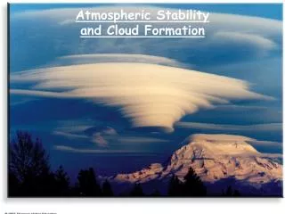
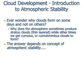
Cloud Development - Introduction to Atmospheric Stability. Ever wonder why clouds form on some days and not on others? Why does the atmosphere sometimes produce stratus clouds (thin layered) while other times we get cumulus, or cumulonimbus clouds to form?

Cloud Development - Introduction to Atmospheric Stability
E N D
Presentation Transcript
Cloud Development - Introduction to Atmospheric Stability • Ever wonder why clouds form on some days and not on others? • Why does the atmosphere sometimes produce stratus clouds (thin layered) while other times we get cumulus, or cumulonimbus clouds to form? • The answer depends on concept of atmospheric stability.....
Stable Environment • Consider a marble in the bottom of a bowl • If you push the marble up the side of the bowl, it will roll back down to the bottom, to its original position
Stable Atmosphere • Parcels in a stable environment will not rise • Vertical motion is inhibited • If clouds form, they will be shallow, layered clouds like stratus
Unstable environment • If the marble is on the top of the bowl and you give it a little push, it rolls off the bowl.... does NOT come back to it's original position • This is an unstable situation
Unstable Atmosphere • Unstable air (parcel) - vertical motion occurs • Commonly produces Cu, Cb clouds • So, how do we determine the stability of the atmosphere?
Rising air parcels and adiabatic cooling • Consider a rising parcel of air • As the parcel rises, it will adiabatically expand and cool • Adiabatic - a process where the parcel temperature changes due to an expansion or compression alone, (no heat is added to or taken away from the parcel) • The parcel expands since the lower pressure outside allows the air molecules to push out on the parcel walls • Since it takes energy for the parcel molecules to "push out" on the parcel walls, they use up some of their internal energy in the process. • Therefore, the parcel cools since temperature is proportional to molecular internal energy
Sinking air parcels and adiabatic warming • A sinking parcel of air: • As the parcel sinks, it will adiabatically compress and warm • The parcel compresses since it is moving into a region of higher pressure • Due to the parcel’s compression, the air molecules gain internal energy • The mean (average) temperature of the parcel increases
Dry adiabatic lapse rate Dry adiabatic cooling= 10oC/1000m What will the temperature of the parcel be if it is raised to 1 km? 30oC
Moist Adiabatic Lapse Rate • At 2 km, the temperature and the dew point temperature lines intersect • The parcel has become saturated • After saturation is reached, the parcel will cool at a smaller rate • A saturated parcel of air, cools at the moist adiabatic lapserate = 6°C/km (3.5oF/1000ft) • What will be the parcel's temperature be at 3 km?
Moist Adiabatic Rate • What will be the parcel's temperature be at 4 km? 14oC
Moist Adiabatic Rate • Why does the parcel cool at a slower rate (6°C/km) when it is saturated and a faster rate (10°C/km) when it is unsaturated? 8oC
Dry versus Moist-Adiabatic Process • The moist adiabatic lapse rate is less than the dry adiabatic lapse rate because as vapor condenses into water in a saturated parcel, latent heat is released into the parcel--partially offsetting the adiabatic cooling
Applying this to determine the stability of the atmosphere • To this point, we’ve learned that a parcel of air will cool at either the dry or moist adiabatic rate when it is lifted. • We now have to compare the temperature of the parcel to the temperature of the atmosphere that surrounds it • If the parcel is warmer (lighter, less dense) than the atmosphere surrounding it--it will rise • Unstable atmosphere • If the parcel is cooler (heavier, more dense) than the atmosphere surrounding it—it will sink • Stable atmosphere
Assessing Atmospheric Stability • The bottom line - • To determine whether or not a parcel will rise or sink in the atmosphere, we must compare the parcel’s temperature (Tp) with that of the environment (Te) at some altitude: • if Tp > Te what will the parcel do? • if Tp = Te what will the parcel do? • if Tp < Te what will the parcel do? Te
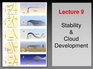
How do we find the temperatures in the atmosphere above us? • Vertical profiles of atmospheric temperature, winds and dew point are collected at 12 and 00 UTC every day from over 1000 locations worldwide by launching weather balloons (rawinsondes) • Temperature, dew point and winds are plotted on a diagram called a Skew-T, Log-P diagram
RAWINSONDE LAUNCH--UZBEKISTAN 100 gram balloon Combat Weather HUAH Rawinsonde
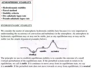
1. Absolute Stability • If a parcel is lifted from the surface it will cool either dry or moist adiabatically • But in either case, the parcel will be cooler than the environment. • This is an example of absolute stability
Absolutely Stable • So an absolutely stable parcel (whether it is unsaturated or saturated) will always be cooler than the environment and will sink back down to the ground • The condition for absolute stability is: Γe<Γm<Γd (Γ is “gamma”=lapse rate) • Γdis the dry adiabatic lapse rate (10°C/km) • Γm is the moist adiabatic lapse rate (6°C/km) • Γe is the environmental lapse rate (In this example= 4°C/km)
Stability of Inversion Layers • How would you characterize the stability of an inversion layer? • Inversions are absolutely stable • Note that the absolute stability criteria: • Γe<Γm<Γd • How do stable layers form in the atmosphere?
Formation of Stable Layers • How does the atmosphere form stable layers? • 1. Radiational Cooling - radiation inversion • 2. Cold air advection at low levels • Behind a cold front (over land) • 3. Warm air moving over cold ground • Fog forming over snow fields
2. Absolute Instability • This is an example of absolute instability • Everywhere on this diagram an unsaturated or a saturated parcel will always be warmer than the environment and will continue to rise • The condition for absolute instability is: Γe> Γd >Γm • Γe is the environmental lapse rate (12°C/km) • Γd is the dry adiabatic lapse rate (10°C/km) • Γm is the moist adiabatic lapse rate (6°C/km)
3. Conditional Instability • This is an example of conditional instability • An unsaturated parcel will be cooler than then environment and will sink back to the ground • The saturated parcel will be warmer than the environment and will continue to ascend • The condition for conditional instability is: Γd > Γe > Γm • Γd is the dry adiabatic lapse rate (10°C/km) • Γe is the environmental lapse rate (8°C/km) • Γm is the moist adiabatic lapse rate (6°C/km)
Conditional Instability - example • Let’s start with a parcel on the surface with a temperature and dew point of 30 °C and 10°C, respectively • The parcel is initially forced to rise in an environment where the environmental lapse rate (Γe) is 8°C/km up to 8 km. • Let's follow the parcel upward…
Conditional Instability - 1km • The parcel must rise dry adiabatically (10°C/km) because it not saturated • The parcel temperature < Te, so something is forcing the parcel upward • Onward to 2km .....
Conditional Instability - 2km • The parcel reaches saturation at 2km • The temperature of the parcel is still < Te, so something is still forcing the parcel upward... • Onward to 3km .....
Conditional Instability - 3km • The parcel now rises moist adiabatically (6°C/km) • The parcel temperature is still cooler than the environment, so something is still forcing it upward.... • Upward to 4km .....
Conditional Instability - 4km • The parcel continues to rise moist adiabatically (6°C/km) • Notice that now parcel temperature = Te • What happens if the parcel is pushed upward just a little???
Conditional Instability - 4km+ • The height where the parcel temperature becomes equal to or larger than it’s environment is level of free convection • The parcel is still rising moist adiabatically (6°C/km) • The parcel will continue to rise until the parcel becomes cooler than the environment (at 9km above the ground) • Above that point, parcel temperature < Te , so the parcel will rise no further • Below 4 km where parcel is cooler than the environment, the atmosphere is stable and there will be no upward parcel movement (something must push the parcel upwards to the level of free convection) • Above 4 km where parcel is warmer than the environment, the atmosphere is unstable, and the parcel will rise on it’s own • This is an example of a conditionally unstable atmosphere... the condition is lifting the parcel above 4 km where it can then rise on it's own
The “real atmosphere” • What are the stabilities of each layer? (Recalling that: Γd=10oC/km Γm=6oC/km) Γm=6oC/km) Γd=10oC/km
Processes that destabilize the atmosphere • 1. Cold air advection aloft • This often occurs when an extratropical cyclone (a winter low pressure system) passes overhead • 2. Surface Heating • Tells us that the atmosphere will be most unstable at time of maximum surface heating
Processes that destabilize the atmosphere • 3. Warm air advection at low levels • This often occurs ahead of a cold front • 4. Cool air moving over a warm surface • A common example is after a cold front passes us and goes into the Gulf of Mexico
Atmospheric Instability and Cloud Development • Where will the base (bottom) of a cloud form? • What determines the height to which the cloud will grow? • Using the previous example of a rising air parcel • On this diagram, where is cloud base? • On this diagram, where is cloud top?
Atmospheric Instability and Cloud Development • On this diagram, where is cloud base? • Where the parcel reaches saturation -- 2 km • On this diagram, where is cloud top? • Where the parcel will no longer be able to rise -- 9 km
Abs Unstable Abs Stable
Atmospheric Instability and Cloud Development - lifting mechanisms • Two questions should arise at this point: • 1. How are vertical parcel motions that create clouds generated naturally in the atmosphere? • 2. What kind (if any) clouds will you visually observe in: • an absolutely stable environment? • a conditionally unstable environment? • an absolutely unstable environment
Atmospheric Instability and Cloud Development - Convection • Convection usually occurs when the surface is heated and a surface parcel becomes warmer than the environment • The vertical extent of the cloud is largely determined by the stability of the environment • In an absolutely stable environment, no clouds will likely form
Atmospheric Instability and Cloud Development - Shallow Convection • In a shallow conditionally unstable or absolutely unstable environment, we might expect clouds to develop, but their vertical growth will be limited... • We may observe • Cumulus Humilis (shallow cumulus) • Stratocumulus
Atmospheric Instability and Cloud Development - Deep Convection • In a deep conditionally unstable or absolutely unstable environment, we would expect clouds with significant vertical development to form • We might observe: • Cumulus congestus • Cumulonimbus