Download
1 / 46
480 likes | 712 Vues
IGS and GGOS Markus Rothacher Institute of Geodesy and Photogrammetry (IGP) ETH Zurich, Switzerland IGS Workshop and Vertical Rates Symposium June 28 - July 2, 2010 Newcastle upon Tyne, England. Overview. Motivation for GGOS and its Mission Status of GGOS and its Structure

E N D
IGS and GGOS Markus Rothacher Institute of Geodesy and Photogrammetry (IGP) ETH Zurich, Switzerland IGS Workshop and Vertical Rates Symposium June 28 - July 2, 2010 Newcastle upon Tyne, England
Overview • Motivation for GGOS and its Mission • Status of GGOS and its Structure • Future GGOS Core Network and IGS • Implementation of GGOS 2020 • Challenges in Earth Monitoring • Conclusions
System Earth (-Mankind): a Very Complex System Sun Space Moon Planets Gravitational effects on orbit and rotation Tides Solar radiation IR Atmosphere Clouds N2,O2,H2O,CO2,O3,etc. Aerosols Snow Icesheets Sea ice Winds Evaporation Loading, deformation Ice-ocean interaction Heat exchange Biosphere, technosphere Ocean Postglacial isostatic adjustment Changes of the ocean floor Changes in vegetation, albedo, composition of atmosphere, … Tectonic Processes, Volcanism, … Solid Earth Source: Kandel, 1980
One of the Problems: Insufficient Data Basis / Quality Nature, 18.08.2005 • Need for a Global Earth Observing System of Systems (GEOSS) realized by the Group on Earth Observation (GEO) • Global Geodetic Observing System (GGOS): geodetic component and metrological basis of GEOSS
Mission of GGOS • The mission of GGOS is to advance geodetic observing methods for Earth and planetary system science and applications by: • defining the geodetic infrastructure needed by science and society; • advocating for the establishment and maintenance of this geodetic infrastructure; • improving the quality and accessibility of geodetic observations and products; • coordinating interaction between the IAG Services, Commissions, and stakeholders; and • educating the scientific community about the benefits of geodetic research and the public about the fundamental role that geodesy plays in society.
GGOS2020 Book • Published by Springer in Summer 2009 • Editors: H.P. Plag and M. Pearlman; manyco-authors • ISBN: 978-3-642-02686-7 • 332 pages, 129.95 € • Reference bookfor all GGOS-relatedactivitiesandplanning • Adoptedas such in the Frankfurt Declaration • (Meeting on a GGOS Inter-governmentalCommittee)
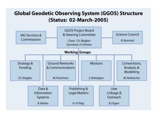
New GGOS Components in Place • Established New Components (January 2009): • Bureau for Networks and Communication: Cambridge Center for • Astrophysics / NASA (Chair: M. Pearlman) • Bureau for Standards and Conventions: Research Group on Satellite Geodesy in Munich (FGS: FESG, DGFI, IAPG; Chair: U. Hugentobler) • Bureau for Satellite Missions GGOS WG on Satellite and Space Missions: Ohio State University (OSU; Chair C.K. Shum) • GGOS Portal (January 2009): • GGOS Portal: BKG (Federal Agency of Cartography and Geodesy, Frankfurt) • GGOS Coordination Office (January 2010): • Coordination Office: ASI (Italien Space Agency)
Global Networks of Observing Stations Data Analysis Centers GGOS Portal (BKG) Access to all information, data, products Combination Centers Earth Observation Satellites / Planetary Missions Modeling Centers New Organizational Elements of GGOS Bureau for Networks and Communication (NASA) Bureau for Conventions and Standards (FGS) Regional and Global Data and Product Centers Archiving and Dissemination Coordination Office (ASI) Mission-specific Data and Product Centers Archiving and Dissemination Users Science & Society WG for Satellite and Space Missions (OSU) Real data; information Meta data; information
IAG/GGOS Services: Backbone of GGOS Geometry IERS: International Earth Rotation and Reference Systems Service IGS: International GNSS Service IVS: International VLBI Service ILRS: International Laser Ranging Service IDS: International DORIS Service IGFS: International Gravity Field Service BGI: Bureau Gravimetrique International IGeS: International Geoid Service ICET: International Center for Earth Tides ICGEM: International Center for Global Earth Models IDEMS: International Digital Elevation Models Service PSMSL: Permanent Service for Mean Sea Level IAS: International Altimetry Service (in preparation) BIPM: Bureau International des Poids et Mesures IBS: IAG Bibliographic Service Gravimetry Ocean Std
IGS Products for GGOS (Earth Observation) • IGS extremely important for GGOS, contributing a large variety of relevant products • Direct IGS Products (global): • Reference frame contribution, ITRF realization • Global site coordinates, velocities and displacements (plate tectonics) • GNSS orbits and clocks; DCBs and in future inter-system biases • Earth rotation parameters • Atmosphere: global water vapor (meteorology and climatology) and electron density (space weather) • Indirect Products made possible by IGS (regional/local): • Regional referenceframes, earthquakedeformation, earlywarningsystems (tsunami, volcanoes, landslides) • LEO orbitsforgravity, altimetry, InSARandothermissions • Local/regional atmospheresoundingandmonitoring
Future Core Ground-Based Infrastructure Core Network (~ 40 Stations): • 2-3 VLBI telescopes for continuous observations • SLR/LLR telescope for tracking of all major satellites • At least 3 GNSS antennas and receivers (controlled equipment changes) • DORIS beacon of the most recent generation • Ultra-stable oscillator for time and frequency keeping and transfer • Terrestrial survey instruments for permanent/automated local tie monitoring • Superconducting and absolute gravimeter (gravity missions, geocenter) • Meteorological sensors (pressure, temperature, humidity) • Seismometer for combination with deformation from space geodesy and GNSS seismology • Additional sensors: water vapor radiometer, tiltmeters, gyroscopes, ground water sensors, … General Characteristics: highly automated, 24-hour/365 days, latest technologies
Wettzell: Future Core Ground-Based Infrastructure Core Network (~ 40 Stations): • 2-3 VLBI telescopes for continuous observations (under construction) • SLR/LLR telescope for tracking of all major satellites (under construct.) • At least 3 GNSS antennas and receivers (controlled equipment changes) • DORIS beacon of the most recent generation • Ultra-stable oscillator for time and frequency keeping and transfer • Terrestrial survey instruments for permanent/automated local tie monitoring • Superconducting and absolute gravimeter (gravity missions, geocenter) • Meteorological sensors (pressure, temperature, humidity) • Seismometer for combination with deformation from space geodesy and GNSS seismology • Additional sensors: water vapor radiometer, tiltmeters, gyroscopes, ground water sensors, … General Characteristics: highly automated, 24-hour/365 days, latest technologies
Twin Telescopes in Wettzell Spain: 4 VLBI telesc. (funded) Australia: 4 VLBI/SLR (funded) NASA: 10 VLBI/SLR (planned) Norway: Twin telesc. (planned) Asia: … VLBI: TWIN SLR: SOS-W
GNSS at GGOS Core Sites • Characteristics: • 3 antennas and receivers to allow for equipment changes • Tracking all GNSS (GPS, GLONASS, GALILEO, COMPASS, …) • Real-time capabilities and high-rate data • Dense L1 network for atmosphere tomogr. L1, RMS = 0.10 mm L1, RMS = 0.12 mm Galileo Experimental Sensor Station (GESS) Wettzell antenna array: monitoring equipment change
GGOS 2020 Implementation Work • GGOS is now working on: • Integrated geodetic products based on observation themes: • Theme 1: Global Unified Height System (M. Sideris et al.) • IGS contribution: positions, co-locationwithgravimeters • Theme 2: Geohazards (global Earth surface deformations and strain rates ) (T. Dixon et al.) • IGS contributions: mentionedbefore; combi. withInSAR • Theme 3: Sea-Level Change, Variability, Forecast(C.K. Shum et al.) • IGS contributions: TIGA project; altimetry / gravitymissionsupport • Action plans for various components of GGOS in 2020, especially for the Global Geodetic Core Network (GGCN) CfP • Sustainability of support: GGOS Intergovernmental Committee
GGOS Intergovernmental Committee (GIC) Problem: long-term support and sustainability of the IAG Services and the global GGOS infrastructure GGOS Intergovernmental Committee (GIC) to support GGOS in attaining its goals (Frankfurt Declaration) by: • Forum for the coordination of resources provided by the member organisations for sustainable GGOS activities • Promotion of GGOS to international entities that require intergovernmental representation (UN, etc.) • Options to link GGOS to higher intergovernmental bodies (e.g., UN Cartographic Conference, UNOOSA, OECD Global Science Forum, etc.) First step: white paper and an inter-agency agreement being prepared by the GIC Planning Group
Challenges in Earth Monitoring for GGOS and IGS • Reliable detection of small, long-term trends: long time series from reprocessing of ground / satellite data Sea Level: Altimetry GFZ, Schöne • Fast event detection and quantification: Real-time processing for early warning systems (tsunami, slides, earthquakes, …) Earthquake: GPS (Nias) GFZ, Bartsch • Combination and Separation: Sensor combinations; separation/validation of signals with complementary data Water Cycle: GRACE GFZ, Schmidt • Information exploitation: portals, up-to-date methods of visualization, information/knowledge management Water Vapor: GPS / VLBI GFZ, Wickert
1. Reliable Detection of Small, Long-Term Trends • Reprocessing: • IGS already did a very big and successful effort • Reprocessing should be possible once a year to allow for homogeneous time series with latest models and param. • Systematic Biases: • Satellite antenna offsets and phase center variations • Orbit modeling deficiencies • Antenna/receiver chances destroy long-term quality: • Run new hardware in parallel for some months, even better: have 2-3 permanent antennas and receivers • Concept for transition to GALILEO-capable antennas/receiv.
1. Reliable Detection of Small, Long-Term Trends Systematic trends in scale due to satellite antenna phase patterns Homogeneous long-term series from reprocessing efforts
2. Fast Event Detection and Quantification • Events show that a fast reaction to natural hazards is also important on the global level • Real- or near real-time global displacement service of the IGS (part of the RT project) ? Earthquake in Chile, Feb. 27, 2010 (DGFI) in Sumatra, Dec. 26, 2004 (GFZ)
IGS real-time developments extremely important • High-precisionpredicted GNSS orbitsandclocks essential formanyapplications: • IGS real-time developments extremely important • High-precisionpredicted GNSS orbitsandclocks essential formanyapplications: 2. Fast Event Detection and Quantification • Early warningsystems • High-precisionorbitsfor LEOs (e.g. crucial forInSAR, GGOS theme 2) • High-rate GNSS data (10-100 Hz): • Buffering: transferofhigh-rate dataonly in caseof an interestingevent • Monitoringofseismicwaves (GNSS seismology) • Earthquakemagnitude, earthquakeruptureprocess, bettertsunamiprediction • IGS real-time developments extremely important • High-precision predicted GNSS orbits and clocks essential for many applications: GPS Seismogram
3. Combination and Separation • Combination is the essence of GGOS: better reliability / accuracy • Combination within the IGS: • Generation of daily SINEX files and combination thereof • Converge on common standards for troposphere modeling and estimation to allow for a combination of the troposphere parameters • Height inconsistencies not absorbed by the troposphere parameters • Combination with other space-geodetic techniques: • Combination of daily SINEX files with VLBI session files (intensives) (site coordinates, ERPs, troposphere parameters) • One common clock for GNSS, VLBI and … • Clocks getting more and more accurate (GIOVE-B, …) • GGOS core sites should establish a unique time reference at the site • “Local ties” for geometry, troposphere and time for combination • Initiated at the Unified Analysis Workshop (UAW) 2009
4. Information Exploitation • Make IGS/GGOS products available to a larger geoscience community: • GGOS portal contributions • Generation of meta data for all products (help by service) • Search capabilities, web catalogues and services • SINEX meta data block • Make available very simple coordinate time series format: • Allows for easy visualization, comparisons, interpretation, etc. • SINEX not suited for this purpose • Huge amounts of data and products: which products should be made available to other geosciences, which are not suited? • A first version of the GGOS portal is ready. Process can start ...
Conclusions • A better Earth monitoring is required to understand the Earth as a system • GGOS is the geodetic contribution to GEO and to GEOSS • Major structural components of GGOS in place; now implementation of GGOS 2020 goals • IGS contributes a very large variety of direct and indirect products • IGS challengesimportantfor GGOS: • Veryefficientreprocessingcapabilities • Real-time productsforearlywarningsystems, etc. • Further steps in combinationwork • Availabilityofmetadataanduser-friendlyaccesstoproducts
GGOS: Monitoring and Modelling the Earth‘s System Reference frames: highest accuracy and long-term stability Global Monitoring Information about Earth System Geometry Station Position/Motion, Sea Level Change, Deformation Space Techniques VLBI SLR/LLR GNSS DORIS Altimetry InSAR Gravity Missions Terrestrial Techniques Levelling Gravimetry Tide Gauges Seismometers Gyros Earth System Sun/Moon (Planets) Atmosphere Ocean Hydrosphere Cryosphere Crust Mantle Core C OM B I N A T I O NS I N T E R A C T I O N S Earth Rotation Precession/Nutation, Polar Motion, UT1, LOD Gravity Geocenter Gravity Field, Temporal Variations Innovative Technologies Interpretation
Ground-Based Component of GGOS GPS VLBI Sup.Grav. Abs.Grav. SLR/LLR Tide Gauges DORIS
Space-Based Component of GGOS Gravity Field … GRACE Follow-on ? GRACE CHAMP GOCE Earth Surface Ocean Altimetry … … TanDEM-X TerraSAR-X JASON-2 JASON-1 Topex/Pos. Atmosphere … Magnetic Field … SWARM CHAMP CHAMP COSMIC MetOp Ice Altimetry … and new mission concepts, satellite constellations, micro-satellites, … … IceSat-2 IceSat-1 Cryosat-2
Space Geodetic Techniques: Latest Technologies • VLBI: • High slew rates (> 5 deg/s) • 1-3 small telescopes at a site • Continuous frequency range (2-18 GHz) VLBI Twin Telescope (Wettzell) • SLR: • kHz laser technology • 2 frequency systems • Higher quantum efficiency Galileo Experimental Sensor Station (GESS) kHz Laser: Lageos Spin (Graz) • GNSS: • GPS, Glonass, Galileo, Compass, … • Sampling > 10 Hz • Real-time • 3 antennas/receivers • DORIS: • 3rd generation DORIS • systems DORIS Beacon (Thule)
Thematic (Geodetic) Observing Systems Integrated GGOS Products
Thematic (Geodetic) Observing Systems / Integrated GGOS Products Idea by Reiner Rummel (Gravity Workshop in Graz): Part 1: Thematic (Geodetic) Observing Systems (and Models) in order to be able to: • cope with the complexity of the Earth system • work on an integrated but limited / manageable part of the Earth system • generate suitable integrated GGOS products Part 2: Connect and link the themes to GGOS: • as partial systems of global Earth system studies • for consistency and quality checks between the thematic (geodetic) observing systems
Three Themes / Integrated Products Selected (1) • Selected at GGOS Retreat in Miami, Feb. 2010: • Theme 1: Global Unified Height System (M. Sideris et al.) • IAG Inter-Commission Project 1.2: Vertical Reference Frames • Complementing the geometric reference frame ITRF • Unification of existing vertical datums • GOCE mission as a major contributor and driver • Enable global GNSS leveling at the 1 cm level • Theme 2: Geohazards (global Earth surface deformations and strain rates for geohazards assessment and disaster prevention) (T. Dixon et al.) • SAR / INSAR data sharing, product benchmarking, standards, combined products through coordination among agencies • Improve effectiveness of geodetic community in geohazards • Work toward an international InSAR service • Theme 3: Sea-Level Change, Variability and Forecasting (H.-P. Plag et al.)
Terrestrial networks Altimetry missions Gravimetry missions Envisat Jason-1 Tide gauge GPS GRACE ICESat CryoSat II Example: Thematic Observing System “Sea-Level Change” Data processing Geodynamic modeling Ocean modeling Glacial-isostatic adjustment Sea-level change (mm/a) Geoid change (mm/a)
InSAR: Densification of Earth‘s Geometrie (e.g. of GNSS Networks) Volcanoes in the Andes (Pritchard & Simons, 2002) Hector Mine earthquake (Courtesy G. Peltzer, UCLA) Combination with GNSS
Three Themes / Integrated Products Selected (2) • Theme 3: Sea-Level Change, VariabilityandForecasting(H.-P. Plag et al.) • Frequent assessment of the global sea level curve and its error budget: GGOS Sea Level Panel • Understanding mass balance in the global watercycle • Sea level rise hazard maps for local sea level • Global GGOS networkofcoresites (crucialfor all themes): • Co-locationofspacegeodetictechniques (SLR/LLR, VLBI, GNSS, DORIS) withlatesttechnologiesand permanent localtiemonitoring • Manyauxiliaryinstruments (clocks, gravimeters, seismometers, meteosensors, watervaporradiometers, …) • Call forParticipation in the Global Geodetic Core Network in preparation
GGOS IGS (IAG Services) • GGOS IGS: • Bureau for Networks and Communication: Cambridge Center for • Astrophysics / NASA (Chair: M. Pearlman) • Bureau for Standards and Conventions: Research Group on Satellite Geodesy in Munich (FGS: FESG, DGFI, IAPG; Chair: U. Hugentobler) • Bureau for Satellite Missions GGOS WG on Satellite and Space Missions: Ohio State University (OSU; Chair C.K. Shum) • IGS GGOS: • GGOS Portal: BKG (Federal Agency of Cartography and Geodesy, Frankfurt) • Test ???
RMS JPS LEGACY Ashtech Z 18 North 0.14 mm 0.17 mm East 0.09 mm 0.10 mm Height 0.12 mm 0.12 mm < June, 10th > June, 10th Wettzell Antenna Array: Equipment Change L1-Solution