Rachel Shoemake , CR ROW EA Angela Parsons, Research Engineer Anna Ferntheil, College Intern
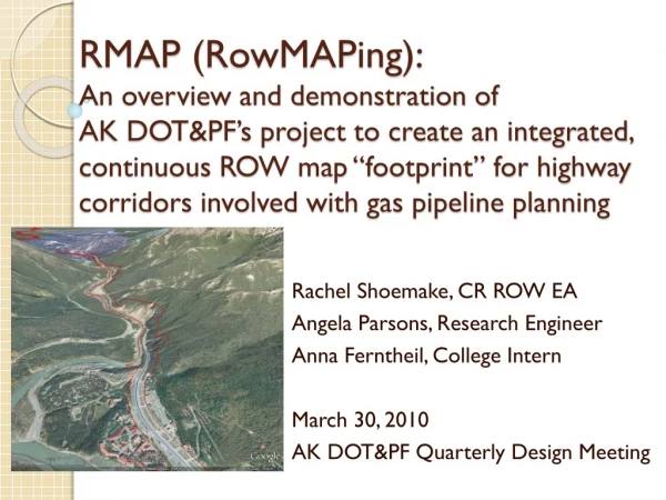
RMAP ( RowMAPing ): An overview and demonstration of AK DOT&PF’s project to create an integrated, continuous ROW map “footprint” for highway corridors involved with gas pipeline planning. Rachel Shoemake , CR ROW EA Angela Parsons, Research Engineer Anna Ferntheil, College Intern

Rachel Shoemake , CR ROW EA Angela Parsons, Research Engineer Anna Ferntheil, College Intern
E N D
Presentation Transcript
RMAP (RowMAPing):An overview and demonstration ofAK DOT&PF’s project to create an integrated, continuous ROW map “footprint” for highway corridors involved with gas pipeline planning Rachel Shoemake, CR ROW EA Angela Parsons, Research Engineer Anna Ferntheil, College Intern March 30, 2010 AK DOT&PF Quarterly Design Meeting
Presentation Overview • Brief Project History and Scope • Live demonstration of mapped layers and functionality using Google Earth viewer
Introductions • Presenters: • Angela Parsons, Research Engineer, RD&T2 • Rachel Shoemake, EA, CR ROW Engineering • Anna Ferntheil, College Intern • Project Involvement: • Bob Wright, Statewide ROW Chief • Louise Hooyer, CR ROW Engineering Supervisor • John Bennett, NR ROW Chief • Tim Sprout, NR ROW EA • Kathy Wickham, NR ROW LS • Drew Pavey, Engineering Tech, CR Materials • Maddie Halloran, High School Mentee
Project History and Scope • Began with a need to provide ROW maps to agencies and consultants requesting info for gas pipeline planning activities • Bob Wright requested NR and CR to compile a list of the projects that reflect the current ROW along the Parks, Glenn, Dalton, Richardson, Elliott, Alaska Highways. • Regions also provided scanned versions of the ROW maps in PDF format on disk.
Project History and Scope (cont.) • Recommended that an approximate centerline footprint of each project be created using mapping software and formatted to be viewed in Google Earth with a hyperlink to each ROW planset in PDF format on the DOT’s external website and/or eDOCsystem. • Based on CR’s successful pilot of this process, Stwd ROW provided funds for regional staff to continue the project.
Project History and Scope (cont.) • Recognized the value of expanding this system to create an approximate footprint of the ROW in a continuous map layer that could ultimately be integrated with other spatial data layers such as aerial images, utility locations, material source locations, roadway assets and conditions, etc. • Developed/tested a process that includes • Extraction of CAD layers where drawing files are available • COGO of ROW legal descriptions from older plansets • Georeferencing of scanned ROW maps using reference base layers and digitizing ROW lines into CAD or GIS. • These layers are combined and attributed using CAD and processed through GIS software to create a Google Earth layer (kml/kmz)
Project History • Also recognized the value of superimposing the actual ROW map sheets onto the Google Earth viewer to more fully document the ROW in an integrated manner • Tested various methods and processed several project overlays with good response from Regional and Stwd ROW • The Northern Region portion of the Glenn Highway is currently available in this format
Project History and Scope (cont.) • Completed to date: • PDF versions of ROW maps • Parks, Dalton, Elliott, Richardson, Glenn, Steese, Alaska Highways • Centerline & ROW footprints created with links to web PDF plansets on eDocs • Parks Highway, Dalton Highway, portions of the Elliot, Glenn, and Richardson Highways • Overlay of ROW plan sheets • Complete Northern Region of the Glenn Highway available now, and the Richardson Highway south of Glennallen will be completed soon
Live Demonstration in Google Earth • The purpose of this demonstration is to illustrate the scope and potential of the project. • It is not intended to show the details on how to work with Google Earth (GE) or these data layers. • Instructions & Google Earth files are now available on the internal webpage. • http://web.dot.state.ak.us/stwddes/row/rmap/RMAPMain.htm
Google Earth (GE) showing centerline footprints completed to date
Zoom into Wasilla area to show several project centerline footprints
Click on a project’s centerline to see more info on the ROW maps
Result of clicking on hyperlink to view maps from eDocs in pdf format
Turn on UA’s BDL layer in Google Earth to see aerial image that is spatially more accurate but older than what is currently in Google Earth
Turn on overlay of ROW map for project overview. Note transparency controls
Use milepost layer to zoom to area of interest in “Glitter Gulch” Parks Hwy MP 236, BDL and Terrain visible
Fly Nenana Canyon Safety Improvement project to display 3D effect
Feedback? Questions? Recommendations? • Utility of this data for your business process? • Ideas on how to maintain datasets into the future • Recommendations on technology to be used to present the data • Internal and/or external to DOT? • Ideas for expansion? Thank You! • And appreciationto those who have worked on, contributed to, supported, and provided feedback for this project.