Download
1 / 7
120 likes | 576 Vues
This study guide covers important geographical concepts such as latitude, climate zones, map projections, and human impacts on the environment. Learn about imaginary lines, vegetation patterns, erosion, and more. Test your knowledge with helpful questions and diagrams.

E N D
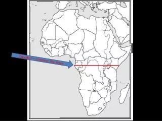
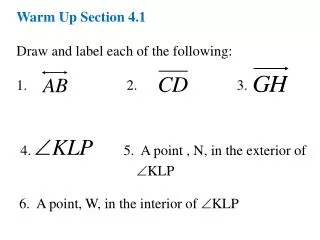
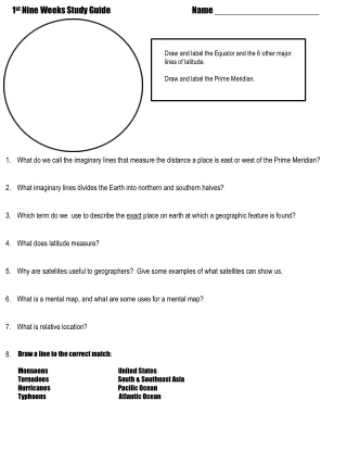
1st Nine Weeks Study Guide Name _____________________ Draw and label the Equator and the 6 other major lines of latitude. Draw and label the Prime Meridian. • What do we call the imaginary lines that measure the distance a place is east or west of the Prime Meridian? • What imaginary lines divides the Earth into northern and southern halves? • Which term do we use to describe the exact place on earth at which a geographic feature is found? • What does latitude measure? • Why are satellites useful to geographers? Give some examples of what satellites can show us. • What is a mental map, and what are some uses for a mental map? • What is relative location? 8. Draw a line to the correct match: Monsoons United States Tornadoes South & Southeast Asia Hurricanes Pacific Ocean Typhoons Atlantic Ocean
The natural vegetation in areas nearest to the Equator consists of(what type?) why? • Why do the countries of Western Europe have a mild marine climate?(think ocean currents…) • What causes erosion? (Name all the forces…) • Besides looking really cool… what is beneficial about volcanoes? • How do we categorize the desert climate zone? (What makes a desert a desert?) • Sketch the orographic form of precipitation. Explain the leeward side of mountain and how it differs from the • windward side. • Which of the following is caused by human activity? • lightning, oil spills, volcanic eruption, or tectonic activity • Describe the relationship between latitude and temperature: (ex: at 0°latitude, what is your temperature • going to be like?)
= ____ _____________ Use pages 22-33 your textbook and your notes to complete the map projections review below: ______________ projection Used for _________ _________. Goode’s __________ Equal- Area Projection ______________ projection Used for _____ _____________. ______________ projection Used for ________ ____________. Why are all maps distorted? Which aspects of the earth are distorted on maps?
Parts of Maps Label the parts of the map below: Which part of the map explains the symbols used on a map? ________________ Which part of the map shows the approximate distance between two places? ________________ Which part of the map is used to show absolute location? ____________________ Which part of the map is used to show orientation? _____________________ Types of Maps ___________ map. Gives specific data or information on a single topic. What does this map show? _________________ ___________ map. Shows features such as lakes, rivers, mountains, relief, and elevation. ___________ map. Shows areas such as countries, states, and cities.
Label the diagram below using the word bank provided. Beside each climate zone write down if it is warm, cold, or seasonal. Equator Arctic Circle South Pole Tropic of Capricorn North Pole Tropic of Cancer Antarctic Circle High Latitude climates (2) Low Latitude climates(the tropics) Middle latitude climates (2) Use your notes to complete the chart below: Name the five factors that influence a region’s climate ( star the one that is MOST SIGNIFICANT):
Use the following word bank to fill in the blanks: botanist GIS alter urban erosion census remote sensing device rural satellite leeward windward deplete 1. _______________ to change, or make different. 2. _______________ a biologist specializing in the study of plants 3. _______________ a periodic count of the population. 4. _______________ a man-made device orbiting the earth, used in communications or to collect scientific data. 5. _______________ the direction from which the wind blows. 6. _______________ on or toward the side which the wind blows. 7. _______________ the wearing away of rocks or soil by the action of water, ice. or wind. 8._______________ A computer application used to store, view, and analyze geographical information. 9. _______________ is the acquisition of information of an object or phenomenon, . by the use of either recording or real-time sensing device(s) that is not in physical or intimate contact with the object (such as by way of aircraft, spacecraft, satellite, buoy, or ship). 10.________________ to use most or all of (something important) 11. ________________ of or relating to cities and the people who live in them 12. ________________ of or relating to the country and the people who live there instead of the city.
True/False • ______ Volcanoes can benefit humans. by depositing ash that contributes to fertile soil in the region. • _______ The leeward side of the mountain is much drier than the windward side. • _______ People are unable to adapt to their physical environment. • _______ Vegetation is an element that causes regional climate patterns. • _______ Ocean currents redistribute heat from one area of the ocean to another. • _______ Most places near the Prime Meridian have a warm climate. • _______ Population is the factor that most strongly affects a region’s climate. • _______ Maps are more accurate than globes.