Tips for the PostGIS Power User
380 likes | 405 Vues
Learn advanced PostGIS functions, geometry constructors, accessors, and spatial predicates. Explore examples and fine-tune spatial queries for PostgreSQL. Enhance database performance with table inheritance and partitioning.

Tips for the PostGIS Power User
E N D
Presentation Transcript
Topics • PostGIS functions • Geometry constructors / deconstructors accessors / spatial predicates • Walk through a few examples. • DE-9IM • Fine-tuning spatial predicates • PostgreSQL • Table inheritance / partitioning • Database tuning
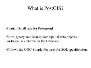
Introduction What is PostGIS? A PostgreSQL database extension that "spatially enables" the server back-end to support the storage of geometric objects in an object-relational PostgreSQL database. http://postgis.refractions.net/docs/
Introduction • Geometry Constructors • ST_GeomFromText(text) • ST_GeomFromWKB(bytea) • Creates a geometry data type in EPSG:3005 projection SELECT ST_GeomFromText( ‘POINT(1718098616348)’, 3005 );
Introduction • Geometry Constructors SELECT geom FROM gps_point_data SELECT geom FROM gps_point_data WHERE time_stamp::date = ‘2007-09-22’::date SELECT geom FROM gps_point_data WHERE time_stamp::date = ‘2007-09-22’::date ORDERBY time_stamp SELECT ST_MakeLine(gps_points.geom) FROM (SELECT geom FROM gps_point_data WHERE time_stamp::date = ‘2007-09-22’::date ORDER BY time_stamp ) AS gps_points; SELECT ST_MakeLine(gps_points.geom) FROM (SELECT geom FROM gps_point_data WHERE time_stamp::date = ‘2007-09-22’::date ORDER BY time_stamp ) AS gps_points;
Introduction • Geometry Constructors • ST_BuildArea() SELECT ST_BuildArea(ST_Collect(geom)) FROM ...
Introduction • Geometry Accessors / Deconstructors • ST_StartPoint() • ST_PointN(geometry, int) • ST_ExteriorRing(geometry) SELECT ST_StartPoint(geom) FROM my_lines;
Introduction • Geometry Accessors / Deconstructors SELECT ST_StartPoint(geom) AS point FROM my_lines SELECT ST_StartPoint(geom) AS point FROM my_lines UNIONALL SELECT ST_EndPoint(geom) AS point FROM my_lines SELECT point FROM (SELECT ST_StartPoint(geom) AS point FROM my_lines UNION ALL SELECT ST_EndPoint(geom) AS point FROM my_lines) AS a GROUP BY point HAVING count(*) =4; SELECT point FROM (SELECT ST_StartPoint(geom) AS point FROM my_lines UNION ALL SELECT ST_EndPoint(geom) AS point FROM my_lines) AS a GROUP BY point HAVING count(*) =4; Caution: GROUPBY uses a geometry’s bounding box !
Introduction • Geometry Accessors / Deconstructors • How to explode a MULTI* table SELECT ST_GeometryN( geom, 1 ) FROM my_multilines; SELECT generate_series( 1, 5 ); generate_series ----------------- 1 2 3 4 5 (5 rows) SELECT ST_GeometryN(geom, generate_series(1, ST_NumGeometries(geom))) AS geom FROM my_multilines SELECT ST_GeometryN(geom, generate_series(1, ST_NumGeometries(geom))) AS geom FROM my_multilines CREATETABLE my_lines AS SELECT geom FROM (SELECT ST_GeometryN(geom, generate_series(1, ST_NumGeometries(geom))) AS geom FROM my_multilines ) AS foo;
Introduction • Geometry Spatial Predicates / Functions • ST_Intersects() • ST_Within() • ST_Touches() • ST_GeomUnion() • ST_SymmetricDifference() • ST_ConvexHull() • …
Sample PostGIS Queries • Identify the locations where clearcut logging occurs closer than 20m to a stream or river. SELECT ST_Intersection(a.geom, ST_Buffer(b.geom, 20)) FROM streams a, logging b WHERE a.geom && ST_Buffer(b.geom, 20) AND ST_Intersects(a.geom, ST_Buffer(b.geom, 20)) SELECT ST_Intersection(a.geom, ST_Buffer(b.geom, 20)) FROM streams a, logging b WHERE a.geom && ST_Buffer(b.geom, 20) AND ST_Intersects(a.geom, ST_Buffer(b.geom, 20)) SELECT ST_Intersection(a.geom, ST_Buffer(b.geom, 20)) FROM streams a, logging b WHERE a.geom && ST_Expand(b.geom, 20) AND ST_Intersects(a.geom, ST_Buffer(b.geom, 20)) SELECT ST_Intersection(a.geom, ST_Buffer(b.geom, 20)) FROM streams a, logging b WHERE a.geom && ST_Expand(b.geom, 20) ANDST_Intersects(a.geom, ST_Buffer(b.geom, 20)) SELECT ST_Intersection(a.geom, ST_Buffer(b.geom, 20)) FROM streams a, logging b WHERE a.geom && ST_Expand(b.geom, 20) ANDST_Distance(a.geom, b.geom) <= 20 SELECT ST_Intersection(a.geom, ST_Buffer(b.geom, 20)) FROM streams a, logging b WHERE a.geom && ST_Expand(b.geom, 20) AND ST_Distance(a.geom, b.geom) <= 20 SELECT ST_Intersection(a.geom, ST_Buffer(b.geom, 20)) FROM streams a, logging b WHERE ST_DWithin(a.geom, b.geom, 20)
Sample PostGIS Queries • What is the average elevation of a lake digitized in 3D? SELECT avg(ST_Z(ST_PointN(ring, generate_series(1, ST_NumPoints(ring)) ) ) FROM ( SELECT ST_ExteriorRing(geom) AS ring FROM lakes WHERE lake_id = 1 UNIONALL SELECT ST_InteriorRingN(geom, generate_series(1, ST_NumInteriorRings(geom)) ) AS ring FROM lakes WHERE lake_id = 1 ) AS foo SELECT avg(ST_Z(ST_PointN(ring, generate_series(1, ST_NumPoints(ring)) ) ) FROM ( SELECT ST_ExteriorRing(geom) AS ring FROM lakes WHERE lake_id = 1 UNION ALL SELECT ST_InteriorRingN(geom, generate_series(1, ST_NumInteriorRings(geom)) ) AS ring FROM lakes WHERE lake_id = 1 ) AS foo SELECT avg(ST_Z(ST_PointN(ring, generate_series(1, ST_NumPoints(ring)) ) ) FROM ( SELECT ST_ExteriorRing(geom) AS ring FROM lakes WHERE lake_id = 1 UNION ALL SELECT ST_InteriorRingN(geom, generate_series(1, ST_NumInteriorRings(geom)) ) AS ring FROM lakes WHERE lake_id = 1 ) AS foo SELECT avg(ST_Z(ST_PointN(ring, generate_series(1, ST_NumPoints(ring)) ) ) FROM ( SELECT ST_ExteriorRing(geom) AS ring FROM lakes WHERE lake_id = 1 UNION ALL SELECT ST_InteriorRingN(geom, generate_series(1, ST_NumInteriorRings(geom)) ) AS ring FROM lakes WHERE lake_id = 1 ) AS foo SELECT avg(ST_Z(ST_PointN(ring, generate_series(1, ST_NumPoints(ring)) ) ) FROM ( SELECT ST_ExteriorRing(geom) AS ring FROM lakes WHERE lake_id = 1 UNIONALL SELECT ST_InteriorRingN(geom, generate_series(1, ST_NumInteriorRings(geom)) ) AS ring FROM lakes WHERE lake_id = 1 ) AS foo
Sample PostGIS Queries • Efficiently, union a set of polygons. SELECT ST_Union(the_geom) FROM ... (takes ~16.7 seconds) Bighorn Creek SELECT ST_Buffer(ST_Collect(geom), 0.0) FROM ... (takes ~4.1 seconds)
Sample PostGIS Queries • Find all docks that are contained completely within a lake, not touching a lake bank. ST_Within? ST_Contains? ST_Touches? What PostGIS functions would you use?
DE-9IM The Dimensionally Extended – Nine Intersection Model • Approach • make pair-wise tests of the intersections between the Interiors, Boundaries, and Exteriors of two geometries and to represent these relationships in an “intersection” matrix
DE-9IM The Dimensionally Extended – Nine Intersection Model Possible values: {T, F, *, 0, 1, 2} • Where: • T == {0,1,2} • F == empty set • * == don’t care • 0 == dimensional 0 – point • 1 == dimensional 1 – line • 2 == dimensional 2 - area
DE-9IM The Dimensionally Extended – Nine Intersection Model Geometry Topology • Boundary • the set of geometries of the next lower dimension Point (dim-0) Polygon (dim-2) Line (dim-1)
DE-9IM The Dimensionally Extended – Nine Intersection Model Geometry Topology • Interior • the points that are left when the boundary points are removed Point (dim-0) Polygon (dim-2) Line (dim-1)
DE-9IM The Dimensionally Extended – Nine Intersection Model Geometry Topology Exterior consists of points not in the interior and boundary Point (dim-0) Polygon (dim-2) Line (dim-1)
DE-9IM The Dimensionally Extended – Nine Intersection Model (b) (a) 2 1 2 1 0 1 2 1 2 ST_Relate(a, b) = ‘212101212’
Sample PostGIS Queries • Find all docks that are contained completely within a lake, not touching a lake bank. SELECT a.id FROM docks a, lakes b WHERE a.geom && b.geom AND ST_Relate(a.geom, b.geom, ‘ ’); SELECT a.id FROM docks a, lakes b WHERE a.geom && b.geom AND ST_Relate(a.geom, b.geom, ‘TFF ’); SELECT a.id FROM docks a, lakes b WHERE a.geom && b.geom AND ST_Relate(a.geom, b.geom, ‘TFFTFF ’); SELECT a.id FROM docks a, lakes b WHERE a.geom && b.geom AND ST_Relate(a.geom, b.geom, ‘TFFTFF212’); SELECT a.id FROM docks a, lakes b WHERE a.geom && b.geom AND ST_Relate(a.geom, b.geom, ‘TFFTFF212’);
Sample PostGIS Queries • Identify linear spatial features that intersect on a line and not at a point. SELECT a.id FROMmylines a, mylines b WHERE a.id != b.id ANDa.geom && b.geom ANDST_Relate(a.geom, b.geom, ‘1*1***1**’); SELECT a.id, intersection(a.geom, b.geom) FROMmylines a, mylines b WHERE a.id != b.id ANDa.geom && b.geom ANDST_Relate(a.geom, b.geom, ‘1*1***1**’);
Table Inheritance CREATE TABLE cities ( name text, population real, altitude int ); inherits CREATE TABLE capitals ( province text ) INHERITS (cities);
Table Inheritance inherits
new_hol_edges hydro_edges admin_edges new_admin_edges hol_edges cwb_edges code code code code code code smallint smallint smallint smallint smallint smallint the_geom the_geom the_geom the_geom the_geom the_geom geometry geometry geometry geometry geometry geometry Table Partitioning Empty table (16 million tuples) inherits x x code check constraints code check constraints code check constraints code check constraints code check constraints
hydro_edges cwb_edges code code smallint smallint the_geom the_geom geometry geometry Table Partitioning -- ADD Rules to parent table CREATE RULE insert_hydro AS ON INSERT TO cwb_edges WHERE code = ... DO INSTEAD INSERT INTO hydro_edges (code, geom) VALUES (NEW.code, NEW.geom); code check constraints CREATE TABLE hydro_edges ( ) INHERITS cwb_edges; ALTER TABLE hydro_edges ADD CONSTRAINT code_check CHECK (code = ...);
PostgreSQL Tuning • The biggest bottleneck in a spatial database is I/O • When setting up a server, invest in a: • great file system • RAID 5 – good for web servers, not spatial DBs • Recommend RAID 1/0 • good memory • adequate CPU(s)
PostgreSQL Tuning • postgresql.conf • Startup • checkpoint_segment_size • # of WAL files – 16MB each • Default: 3 • Set to at least 10 or 30 for databases with heavy write activity or more for large database loads • Possibly store the xlog on a separate disk device • shared_buffers • Default: ~32MB • About 1/3 to 3/4 of available RAM
PostgreSQL Tuning • postgresql.conf • Startup • constraint_exclusion • Default: “off” • Set to “on” to ensure the query planner will optimize as desired.
PostgreSQL Tuning postgresql.conf Runtime work_mem Memory used for sort operations and complex queries Default: 1MB Adjust up for large dbs, complex queries, lots of RAM Adjust down for many concurrent users or low RAM
PostgreSQL Tuning postgresql.conf Runtime maintainence_work_mem Memory used for VACUUM, CREATE INDEX, etc. Default:16MB Generally too low – ties up I/O, locks objects while swapping memory. Recommend 32MB to 256MB on production servers with lots of RAM, but depends on number of concurrent users.
PostgreSQL Tuning postgresql.conf Runtime On development systems with lots of RAM and few developers… SET work_mem TO 1200000; SET maintainence_work_mem TO 1200000;
PostgreSQL Tuning postgresql.conf Runtime client_min_messages Useful when writing PL/Pgsql functions. SET client_min_messages to DEBUG; CREATEFUNCTION my_function () RETURNSTEXTAS $BODY$ BEGIN ... RAISEDEBUG ‘myvar: %’ var; ...
Performance Tips • Spatial function calls can be expensive. Be efficient in their use - avoid unnecessary/duplicate function calls. • Use St_Expand where appropriate • Use one relate call instead of 2 or 3 other spatial calls. • Use St_Distance()==0 instead of intersects() on large geometries • Avoid St_Buffer() unless you need a buffered geometry
Performance Tips Partition your data into Most Frequently Used (MFU) and Least Frequently Used (LFU).
Questions Questions
Appendex A // PostGIS and JTS Class.forName(“org.postgresql.Driver”); Connection conn = DriverManager.getConnection(“jdbc:postgresql://...”); WKBReader wkbReader = new WKBReader(); WKBWriter wkbWriter = new WKBWriter(); String query = “SELECT the_geom FROM my_spatial_table WHERE the_geom && ST_GeomFromWKB(?, 3005)”); PreparedStatement pstmt = conn.prepareStatement(query); pstmt.setBytes(1, wkbWriter.write(myJTSPolygon); ResultSet rs = pstmt.executeQuery(); while(rs.next) { Geometry g = wkbReader.read(WKBReader.hexToBytes( rs.getString(1))); ... // Do stuff with Geometry }