Download
1 / 29
290 likes | 474 Vues
Use of the NCEP Short Range Ensemble Forecast System Eastern Region of the NWS. Rich Grumm NWS WFO State College, PA With contributions from Jeff Tongue NWS WFO Brookhaven, MY 25 March 1230_1500. Overview. Over a decade experience using the SRE F and GEFS

E N D
Use of the NCEP Short Range Ensemble Forecast System Eastern Region of the NWS Rich Grumm NWS WFO State College, PA With contributions from Jeff Tongue NWS WFO Brookhaven, MY 25 March 1230_1500
Overview • Over a decade experience using the SREF and GEFS • Good access to SREF, GEFS, NAEFS and experimental versions • Main uses • Web site for mean/spread/anomalies • Case studies to use EFS data • Challenges better systems and longer predictability horizons! • Focus on recent examples: • Winter storms • Dealing with uncertainty and short predictability horizons • Current work and future work
Experiences Using SREF older • General • Follows bias and errors in GEFS • Longer ranges 24-84 hours similar trends • Known bias 2m temperatures and Precipitation type • SREF may be more relied on East of Rockies • Good forecast tool at shorter predictability horizons • Generally 24-60 hours depending on predictability horizons • Convergence on solutions issues 17 March snow How and when do we know converging toward good solution? newer
Focus on recent examples • Three Events • 3 March and 17 March large anticyclone and weak low GEFS-SREF forecast too much QPF too far north short predictability horizons • 12 March deep cyclone tracked QPF and cyclone too far south and east • Calibration and Predictability horizons • Need some calibration and tools for this? • 17 March DC snow case
Large Spreadcyclone track shifted southNote GEFS had same predictability horizon issues Low Spread clearly more confident- GEFS 12Z 15 March
Same at 500 hPa spread rapidly decreased on 14-15 March ARE WE LEVERAGING Uncertainty information not very well in some cases Many WSW products issued too early too far north!
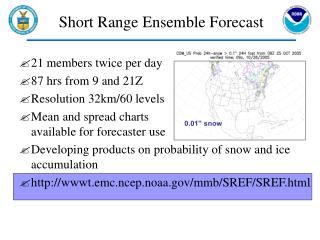
Short Predictability horizon Dramatic Impact on QPF Shield The high probability of QPF over PA panel a too high and not calibrated
General Issues • GEFS-SREF similar (3 March in Appendix) • QPF shields and areas of high spread • When does one know when converging toward solution? • Predictability Horizons often short • High confidence is often in the 24-60 hour range • SREF/GEFS both tend to converge within a cycle or two sometimes the 3-hour cycle difference!
Solutions converged fast 1500 UTC 15 March continued to improve
On the edge of a storm is really difficultlittle snow fell in PA and now mixed!
DC area did better with SREF 17 Marchexperimental pygrib plumes
Uncertainty Products • Basic products not well used or exploited • Pretty simple stuff and should be used more • Mean/spread and of course probabilities • Ensemble sensitivity information • Not easy stuff not well understood • Should we and how do we improve this?
Sensitivityhttp://dendrite.somas.stonybrook.edu/CSTAR/Ensemble_Sensitivity/Plots/2014031400/region1/day3/EOF_4fig_NCEP.gifSensitivityhttp://dendrite.somas.stonybrook.edu/CSTAR/Ensemble_Sensitivity/Plots/2014031400/region1/day3/EOF_4fig_NCEP.gif
Predictability Horizons and Uncertainty • Repeatedly impacts forecasts and forecaster • Hard to deal with for range of reasons • Disparate model/EFS solutions • 3-4 day skill one event 1-2 day skill next • D(Prog/dt) in each event is unique! • One storm tracks south next north • Can change run-to-run sometime
12 March QPF farther north and west Forecasters viewed earlier forecast as “What will occur” over forecast snow south and east Training issue?
SREF/GEFS Summary • SREF and GEFS do well in 1-2 day range • Uncertainty really impacts forecasts • Need tools and calibrated products to deal with this? • Human Forecasts may not reflect diminished skill longer ranges • Some of the things we are doing
WFO State College-PSU • Ensemble Products Research Team • winter weather Dec 2013-March 2014— • Student Projects • PYGRIB and MATLAB improve products • Steven Greybush leading group • Using climate data in forecast process • Improve training to use EFS better • Uncertainty and high impact weather • Case based and GEFS-R based
NWS-Brookhaven-SUNY Stony Brook • CSTAR Effort on Ensembles: • Ensemble Sensitivity and predictability • Web and AWIPS experimental products ALPS • Training on uncertainty • Will talk about Thursday but critical issue on effective use EFS data
Current work and future work • NWS-State College-PSU Ensemble Research • winter weather Dec 2013-March 2014— • Student Projects • PYGRIB and MATLAB improve products • Steven Greybush leading group • Improve training to use EFS better • Uncertainty and high impact weather • NWS-Brookhaven • Ensemble Sensitivity and predictability • Web and AWIPS experimental products • Wider training activities
Pygrib and netCDF ProductsStudent projects PSU crowd sourcing
Summary • Over a decade experience using the SREF/GEFS • Main use most NWS is in AWIPS limited functionality • State College-PSU Anomalies and Probabilities • Brookhaven-SUNY-SB Ensemble SENSI • Challenges • Predictability horizons and forecast related issues • Better products and more efficient use of data • SREF/GEFS Experience recent examples • High confidence often in 1-2 day range • Often huge uncertainty in 2-3.5 (SREF) and 2-16 (GEFS)
Acknowledgements • NCEP for support and access to data over the past 15 years • Yuejian Zhu and Jun Du • Christine Caruso-Magee experimental data • PSU for all local support and collaboration • WFO Brookhaven sensitivity data