Download
1 / 36
360 likes | 512 Vues
Hydrology Program Managers Conference SR Breakout Session December 5, 2002 Ben Weiger Chief, Hydrologic Services. GIS Support for Field Offices. GIS Support. Internet Mapping Service (IMS) Information Team Status SR ARC IMS Server Status Status of FFMP script conversion GIS training.

E N D
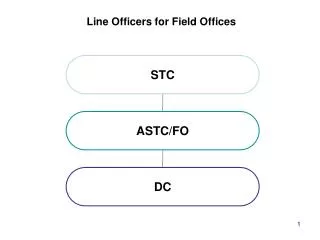
Hydrology Program Managers Conference SR Breakout Session December 5, 2002 Ben Weiger Chief, Hydrologic Services GIS Support for Field Offices
GIS Support • Internet Mapping Service (IMS) Information Team Status • SR ARC IMS Server Status • Status of FFMP script conversion • GIS training
IMS Information Team Status • SR representative – Jack Settelmaier (SSD) • Team analysis will include • potential impacts on NWS web servers • IMS software options • ease of access • national consistency • workload considerations • cost effectiveness • Team will not address • web interface design • data content • product format.
IMS Information Team Status • Team Decision - use ArcIMS – no compelling reason to move from earlier team recommendation • No robust COTS with IMS functionality • Follows direction of NOAA • Used by NOS Enterprise GIS effort • Briefed to and encouraged by Adm. Lautenbacher
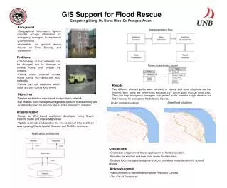
IMS Team Status • Issues • Development of business case going slowly • Team members committed to many other projects • Need all team members to contribute • Need for meeting in lieu of conference calls • December in Silver Spring • Deadline for completion of team’s work extended to end of February 2003. • WGRFC providing various shape files for the NWSH ARC IMS server to support the IMS Information team briefing to Corporate Board.
Internet Mapping URLs • NDFD Demonstration • http://140.90.22.241/website/ndfd/ndfd • Storm Reports • http://140.90.22.241/website/stormreport/viewer.htm • River Conditions • http://140.90.22.241/website/riverconditions/viewer.htm • WGRFC Effort (In Progress) • http://140.90.22.241/website/coopprecip/viewer.htm • NOS Enterprise Info • http://www.csc.noaa.gov/GeoTools/htm/special.htm
SR ARCIMS Server Status • Dissemination and Enhancement Team within CWWD providing technical oversight of this project. • Goal to have ARCIMS on LINUX development workstation/server in December 2002. • HSB/SSD working closely with DET to get development workstation/server online. • GIS team will contribute to developing a GUI for the SR ARCIMS server.
FFMP Script ConversionAvenue to Visual Basic • HSB raised this issue during HSD conference call. • NWSH took action to document legacy software requirements and submit an unfunded requirement to the Corporate Board. • NWSH plans to coordinate draft document with regions prior to official submission.
GIS Training • HSB/SSD plan to canvass field offices for GIS training needs. • HSB investigating regional GIS training classes opportunities at the NOAA Coastal Data Development Center (NCDDC) and NOAA Coastal Services Center (CSC). • Both locations offer significant discounts for ESRI GIS training. • If you know of other institutions offering GIS training at discount prices, please let us know.
Hydrology Program Managers Conference SR Breakout Session December 5, 2002 Ben Weiger Chief, Hydrologic Services Customer Surveys
Customer Surveys • Regulations for soliciting customer feedback during meeting, conferences, or workshops less stringent than web-based surveys. • Do not require any formal approvals from NOAA. • Do not use the word “survey” in any handout provided to customers at a meeting, conference, or workshop to solicit feedback on NWS products and services.
Customer Surveys • NWS has developed a baseline customer survey to acquire feedback on experimental products/services via the INTERNET. • http://products.weather.gov • Field offices can edit the baseline survey to solicit feedback from customers on specific experimental products and services.
Customer Surveys • NOAA has web page with guidance about conducting customer surveys • www.cio.noaa.gov/itmanagement/praguide.htm • Click on customer surveys and Frequently Asked Questions for further information. • Web page above has an approved web based survey that you can tailor to a specific product/service. NOAA clearance takes about 2-3 weeks.
COOP Modernization Status COOP Program SR Breakout Session December 5, 2002 Ben Weiger Chief, Hydrologic Services
COOP Modernization • Network spatial study • Phase I (Rescue) • Phase II (Modernization)
Figure 6. Color scheme number of current COOP sites per 20 x 20 mile grid 2/4/2002 Needed: One site per 20 x 20 mile grid (gray box)
Figure 41. Color scheme number of current COOP sites per 60 x 60 mile grid Problem: Most sites not reporting daily temp and precip data.
COOP Program Modernization Phase I • Implementation: • $1.9M investment for FY02 • 5,000 temperature (MMTS) display units • 300 F&P upgrades deploy early FY03
Budget Status FY 2002 Budget • $300K included in OAR U.S. Senate mark for improved daily temp. forecasts (modeling & sensors) • Updated phone lines at New England sites to report temperature hourly FY 2003 Budget • President’s FY03 budget allocates $3M for COOP modernization • Modernization of 200 platforms for Southeast US
COOP Modernization Plan Phase II Status - Budget http://140.90.22.241/website/coop
COOP Program Phase II Project Goals Modernization • Improve Drought & Climate Monitoring • Improve Snowfall Monitoring • Improve Flood Forecast Accuracy • Improve Local Temperature Forecasts • Increase Data Availability
NWS Challenges • Drought & Climate Monitoring • Fill gaps in coverage – west & Alaska • Make county-level data available • Snowfall Monitoring • Increase density/reporting for improved winter crop assessment/planning • Currently only 1,500 sites report daily • Flood Forecasts • Increase number of gages per radar to improve radar precipitation estimates • Reduce river forecast errors for improved flood mitigation decisions
NWS Challenges (cont.) • Temperature Forecast • Expand basis for local forecasts beyond 1,000 airport sites used today • Make forecasts more representative of surrounding area • Data Availability • Expand real-time availability of observations beyond airports • Eliminate current one day to 2 months lag in COOP data availability • Data Accuracy and Quality • Standardize observing biases • Improve and automate quality control of data
Prediction – Forecast Accuracy/Increased Data Availability Benefit: Improved Flood Forecast Accuracy • Hourly COOP precipitation data will be combined with radar estimates for more accurate real-time precipitation estimates. • More accurate precipitation estimates improve forecast accuracy. COOP gage reports 24 hr Raw Radar Estimate 24 hour RFC-Wide Multisensor Precipitation Estimate
Improving Temperature Forecast Accuracy • Decrease Temperature Forecast Error from 4.6º F to 3.1º F • Increase Daily Reporting Temperature Sites from 1,500 to 8,000 Devastating Florida Freeze January 18, 1997 • Timely CO-OP observations would have allowed for more accurate county forecasts • $400 M in damages could have been mitigated
Actions • Modernize Temperature and Precipitation Gages at locations identified in the spatial density study • Add Automated Data Communication, Dissemination, & Archiving at these sites • Temperature and precipitation data reported every hour • Snowfall data reported every day • Improve Spatial Distribution (Increase Density in West & Alaska) • Equip 1,000 Sites with Soil Moisture,Temperature, Humidity, & Evaporation Sensors • Disseminate All Data Via Internet
COOP Modernization System Architecture
Outcomes: Economic Benefits Agriculture/Water Management • Better Data for Local Decision Making (Water/Drought Management/Crop Planning) Power Industry • Improve Energy Load Forecasting for Improved Pricing Efficiency • Potential Consumer Savings of $30M/day per Degree Improvement (Energy Industry) Weather Risk Industry • Improve Market Efficiency of Climate/Weather Related Insurance Contracts (Weather Risk Management Association) Federal Government • Support County-Level Presidential/USDA Disaster Declarations for Drought, Snowstorms, Floods, etc. (FEMA)
Secretarial/Departmental Initiatives • Provides for the enhancement of the national economy. • Support the decision-making necessary for Presidential Disaster Declarations. • Improved data resolution: • Supports local drought and flood mitigation reducing the annual cost to the nation. • Support more efficient power generation. • Provides for timely assessments to climate variability and change. • Enhances the NWS mission of protection of life and property.
Schedule • FY 2001: Completed COOP network spacing plan • FY 2002: Upgraded 105 COOP sites for the New England TAQ Demonstration Project. • FY 2003: Establish a second demonstration network in the Southeast United States (upgrade 200 COOP locations) • FY 2004: Begin full Coop modernization (upgrade 1200 COOP locations) • FY 2010: Complete acquisition phase • FY 2011: Complete implementation • FY 2012: Steady-state network operation