Natural and Technological Hazards & Ecology
170 likes | 463 Vues
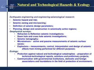
Natural and Technological Hazards & Ecology. Earthquake engineering and engineering-seismological research: Seismic hazard and risk; Seismic zoning and microzoning; Definition of seismic design parameters; Planning, design and construction in seismically active regions;

Natural and Technological Hazards & Ecology
E N D
Presentation Transcript
Natural and Technological Hazards & Ecology Earthquake engineering and engineering-seismological research: • Seismic hazard and risk; • Seismic zoning and microzoning; • Definition of seismic design parameters; • Planning, design and construction in seismically active regions; • Geophysical surveys: • Refraction & Reflection seismic investigations; • Down hole and cross hole seismic investigations; • Seismic tomography; • Microtremors - active and passive measurements of seismic surface waves; • Explosions – measurements, control, interpretation and design of seismic effects from mining performed for different purposes; • Ecology: • Protection against natural and technological catastrophes – preparation of technical-technological reports, solutions and preliminary projects; • Communication with governmental institutions, domestic and foreign associations and foundations in the field of protection of environment;
Natural and Technological Hazards & Ecology Map of Epicenter of Earthquake M 4.0 to M<8.0 Period:1900-2000 Skopje; M = 6.1; I=IX MCS 26-07-1963 Pehcevo-Kresna M = 7.8;I=X MCS 04-04-1904 Debar; M = 6.5; I=IX MCS 30-11-1967 Valandovo; M = 6.7; I=X MCS 08-03-1931 Bitola; M = 5.2; I=VII MSC-64 01-09-1994 Podgradec-Ohrid; M =6.7; I=IX MCS 18-02-1911
GEOLOGIC & SEISMOGIC BASE FOR LAND USE PLAN FOR SKOPJE d-r. Gavril Mirakovski-dipl.ing.geoph.; Prof. d-r. Snezana Stamatovska-dipl.civ.eng.; Slobodan Micajkov-dip.elec.eng. 1. GEOLOGICAL BASE : • Seismotectonic map • Engineering-geologic map • Hydrogeology map • Ground Bearing capacity according to litology • Land use planning 2. SEISMIC ZONING • Return Periods 100, 200, 500, 1000 & 2500 years. • 3. DBMS & GIS applications
SEISMIC ZONATION: Ground Acceleration Distribution amax for RP 1000 years
SEIZMIC HAZARD from “MAN MADE” Sources • mining explosions - • d-r. Gavril Mirakovski-dipl.eng.geoph. Measuring points distribution in the mine filed MP-1
Natural and Technological Hazards & Ecology Strong Motion Laboratory • In order to provide permanent maintenance of the installed network and processing of the obtained strong motion records, the IZIIS Strong Motion Laboratory was established • The instruments are located in all the regions of Macedonia characterized by pronounced seismic activity and are installed on various types of structures – dams, bridges, tall buildings, industrial plants, administrative and educational buildings providing continuous monitoring of the seismic activity • In almost 40 years of operation, SMN recorded earthquakes with magnitudes 3<M<7.2 resulting in a database with more than 1200 strong motion records obtained from near and distant seismic sources on different soil conditions (bedrock and soil deposit), and different types of structures
Natural and Technological Hazards & Ecology Monitoring and recording Strong Motions Distribution of instruments Seismic monitoring on Strezevo Dam
Natural and Technological Hazards & Ecology Strong Motion Networks
Natural and Technological Hazards & Ecology Strong Motion Networks • Instruments are installed in seismic active regions in Republic of Macedonia thus providing data necessary for: • Improvment of ingeneering practice, especially for aseismic design of new and reconstruction of existing buildings; • Improvement of Tecnical Regulation and Biuilding Codes for design and construction in seismic active regions • Seismic hazard assessment, physical and urban planning; • Design and construction of essential structures (schools, hospitals)
Natural and Technological Hazards & Ecology Real Time Strong Motion Network • 3D Real Time Strong Motion Network in Ohrid (1976) 9 in Boreholes 4 on Free Field 6 on Structure • Real Time Strong Motion Network (2010) 13 GURALP Instruments covering territory of RM
Natural and Technological Hazards & Ecology 3D Real Time Strong Motion Network
Natural and Technological Hazards & Ecology Real Time Strong Motion Network • UKIM-IZIIS in colaboration with CMC (Crisis Management Centre) started an iniative to implement the Shake Map system in Republic of Macedonia • CMC provides location for the instruments (GURALP) with necessary infrastructure (electric power, internet connection) in its premises throughout Republic of Macedonia • UKIM-IZIIS chose 13 locations and installed GURALP instruments, as part of the ShakeMap System Network • Definition and realization of two centers (one in UKIM-IZIIS, one in CMC Headquaters) for data acquisition and presentation
Natural and Technological Hazards & Ecology Real Time Strong Motion Network
Natural and Technological Hazards & Ecology Real Time Strong Motion Network • Responsible authorities for search and rescue operations wants rapid information on areas affected; • Government and Emergency Management need to know the likely financial impacts; • Consulting Engineers need to know the effects on structures and how close to design limits the structure has endured; • Earthquake Engineers want to know the parameters of the shaking; • Seismologists want to know the details of the fault system that caused the event; • Media want to know how the Public will be affected; • Business Leaders need to know the likely affect on their multiple locations and campuses and the safety of their structures
Natural and Technological Hazards & Ecology • THANK YOU