Download
1 / 1
10 likes | 159 Vues
Preprocessed AVIRIS Imagery. Raw AVIRIS Imagery. Sand. Inversion Output Water Properties. Coral. SAV. Inversion Output Water Properties. Bathymetry. Image Geometry Explicit pixel by pixel subsurface angles. Spectral Input Parameters Aquatic Absorption Properties

E N D
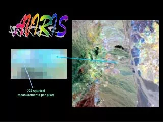
Preprocessed AVIRIS Imagery Raw AVIRIS Imagery Sand Inversion Output Water Properties Coral SAV Inversion Output Water Properties Bathymetry Image Geometry Explicit pixel by pixel subsurface angles Spectral Input Parameters Aquatic Absorption Properties Generic Bottom Reflectance Image Geometry Explicit pixel by pixel subsurface angles Illumination (solar) View (AVIRIS) Bottom Albedo (550 nm) Bathymetry Illumination (solar) View (AVIRIS) Sand Coral Rubble Acropora cervicornis Acropora palmata Coral SAV Montastraea annularis Siderastrea siderea Porites spp. DCS 30cm res. AVIRIS ~3m res. Dictyota spp. Thalassia testudinum Gorgonians Spectral Endmembers Unmixing Output Hidden Benthic Composition http://earthscience.arc.nasa.gov/sge/coral-health Imaging Spectroscopy, Spectral Analysis, and Radiative Transfer Modeling in Support of Coral Reef Ecosystem Biodiversity Research for Coral Patch Reefs in Puerto Rico L. Guild1, R. Armstrong2, B. Lobitz3, J. Goodman2, F. Gilbes2, R. Berthold1, J. Torres4, Y. Detres2, C. Zayas2, S. Williams2, O. Tzadik2, and J. Kerr5 1NASA Ames Research Center, Moffett Field, CA 94035, USA, 2University of Puerto Rico at Mayagüez (UPRM), Mayagüez, PR 00681, USA, 3University Corporation at Monterey Bay, NASA Ames Research Center, Moffett Field, CA 94035, USA 4NASA Postdoctoral Program, NASA Ames Research Center, Moffett Field, CA 94035, USA, 5Nova Southeastern University, Dania Beach, FL, 33004, USA Abstract AVIRIS Data Preprocessing Radiative Transfer Modeling Approach Field Measurements The first step of the image preprocessing is suppression of the near-infrared glow (i.e., anomalously large values) in low-light AVIRIS 2004 and 2005 imagery. This glow was caused by stray- light leakage following an upgrade to the instrument prior to the 2004 flight season. It is suppressed by calculating a correction based on the glow’s cross track profile and the difference between the central stripe of "good" data and the adjacent incorrect pixel values that include the contribution from the stray-light (Lobitz et al. 2009). The second preprocessing step is atmospheric correction, performed using Tafkaa, a Naval Research Laboratory algorithm designed to address the confounding variables associated with shallow aquatic applications (Gao et al. 2000, Montes et al. 2003, Montes et al. 2001). Details of the atmospheric correction method used can be found in Lobitz et al. (2009). The third preprocessing step, a spectral normalizing procedure based on Hedley et al.'s (2005) variation of Hochberg et al.'s (2003) method was used to reduce the effects of sun glint (i.e., specular reflection from the water surface). NASA’s Twin Otter aircraft and imaging sensors have been used to fly over ongoing coral reef research sites in Southwestern Puerto Rico to collect high resolution imagery to support coral reef ecosystem research. The goal is to better understand how light scatters and reflects in shallow aquatic ecosystems. These results will lead to the optimization of current and future remote sensing sensors and data for ecosystem research in the coastal zone. Specifically, this airborne capability addresses the use of remote sensing and field data to interpret reef habitat variability and biodiversity in sites experiencing bleaching, disease, and intense wave action from hurricanes that may become more frequent due to climate change. The airborne sensors consist of a high resolution digital camera system (DCS, NASA Ames Airborne Sensor Facility) and the Airborne Visible Infrared Imaging Spectrometer (AVIRIS, NASA Jet Propulsion Laboratory). The project began with the Caribbean August/September 2005 coral reef bleaching event and a subsequent airborne mission in December 2005 over Puerto Rico and the U.S. Virgin Islands. This research focuses on the remote sensing data collected over Puerto Rico following the bleaching event. After AVIRIS preprocessing, two routes were followed to yield benthic-cover images: 1) an analytical inversion model and spectral unmixing and 2) Hydrolight model runs. Hydrolight results were benthic composition images. Field measurements of benthic types including spectral properties and species composition are integrated with the AVIRIS data to interpret coral reef ecosystem biodiversity. Science objectives for this study included using AVIRIS data and field measurements to assess reef ecosystem community structure following the 2005 coral bleaching event, as well as improve the interpretation of reef habitat variability and biodiversity from imaging spectroscopy (hyperspectral) data related to algorithms that could be used for future HyspIRI data. A Hydrolight table-look-up procedure was developed using the expected domain of water components, depths, and field-measured benthic spectra. A large number of Hydrolight model outputs over the expected domain of water quality parameters (CDOM, chlorophyll concentration, minerals), spectral mixtures of coral, sand, and submerged aquatic vegetation (See field spectra graph), and depths were tabulated. Those results were then searched to find the best match to the pre-processed AVIRIS reflectance data. • Reef benthic type spectra • Photogrids • GPS • Spectra of calibration targets • Aeronet station: aerosol optical depth • Water optical profiler • Upwelling radiance, Lu • Downwelling irradiance, Ed • Surface Ed, Es Coral Sand SAV Values 0-100% using a rainbow color scheme from purple to red. A pure pixel corresponds to 100% of a given cover type. Inversion Model and Unmixing Approach Following image preprocessing corrections, a semi-analytical inversion model is used to retrieve estimates of bathymetry and water properties from measured surface remote sensing reflectance to correct for water column effects in the imagery. Aquatic absorption properties are a combination of absorption properties of pure water and empirical spectra derived from field data and Hydrolight runs (Lee et al. 1998, 1999). The generic bottom reflectance used in the model is an average sand spectrum from the study area. The Inversion Model is applied to derive water properties, bathymetry, and bottom albedo. We then proceeded with defining spectral endmembers from measured field data and performed the benthic classification using unmixing techniques (Goodman and Ustin 2007, Goodman 2004). Generic spectral endmembers of coral, sand, and algae are used together with the inversion model outputs (water properties, bathymetry, and bottom albedo) as well as the spectral input parameters and image geometry in the Forward Model. The next step is to take this information and run the unmixing model on the AVIRIS data to output a benthic composition image of coral, sand, and algae. Assessment of Inversion and Hydrolight Modeling Approaches Field Spectra Spectra normalized to unity at 550nm show differences in spectral shape between benthic cover types, e.g., live coral has a broad peak between green and red wavelength and most features show a chlorophyll absorption feature at 680nm. Airborne Data • AVIRIS (Airborne Visible Infrared Imaging Spectrometer) • Operated by NASA Jet Propulsion Lab • NASA Wallops Twin Otter • 224 contiguous spectral channels (370-2500 nm) • Visible range: 410-700 nm (31 bands) • 10 nm nominal channel bandwidth • High signal to noise ratio • Altitude: ~3.5 km (Twin Otter) • AVIRIS spatial resolution: ~3m (Twin Otter) • Digital Camera Systems (DCSs) on low altitude aircraft • Cirrus: Operated by UC Santa Cruz Airborne Sensor Facility, NASA Ames • Kodak: Operated by NASA Ames and Fireball Information Technologies • Spatial resolution: 30cm at 6000ft • NOAA’s 4-m LiDAR bathymetry acquired in SW Puerto Rico in 2006-07 Preprocessed AVIRIS Image Coral Reef Ecosystem Benthic Components Inversion Model Inversion and Unmixing Output Hydrolight Transformation Output Difference AVIRIS Imagery Image Preprocessing Correct Stray Light Anomaly Hedley Glint Removal Tafkaa Atmospheric Correction Spectral Input Parameters Aquatic Absorption Properties Generic Bottom Reflectance Inversion Model Coral Sand SAV Purple represents locations where the inversion model output values were lower than the Hydrolight values. Values increased through the rainbow to red where inversion model values are higher than the Hydrolight values. Yellow/green locations are where the output approaches were similar. The differences between the results for the two methods (inversion model and unmixing approach and Hydrolight radiative transfer modeling approach) for the three components (coral, SAV, and sand) were then examined; however, the inversion/unmixing approach included a shade component (scaling parameter), so the mixture types were not the identical. There is good agreement of spatial benthic structure between the two approaches. Unmixing Model Acropora cervicornis (staghorn coral) San Cristobal patch reef, La Parguera Summary • Based on field observations and knowledge of the areas, these results overestimate the SAV component, overestimate the coral component slightly, and underestimate the sand component • The interpretation of the benthic surface is complicated by the heterogeneous configuration of surface features resulting from the assortment of surface elements and their morphology, spatial arrangement, and mutual shading • Substantial image preprocessing may have affected the modeling results AVIRIS Dec 2005, Mosaic of La Parguera, PR 2004 2005 2006 Forward Model Unmixing Model Collaborators AVIRIS Team - JPL, Airborne Sensor Facility - Ames, Fireball Technology Funding NASA Interdisciplinary Research in Earth Science NASA Ocean Biology and Biogeochemistry Program 2007 2008 2009 3-m spatial resolution