Utilizing and Visualizing Geolocation Data with SharePoint 2010: Insights from Timothy Ferro
In this presentation from the FEDSPUG event on July 11, 2013, Timothy Ferro explores SharePoint 2010 as a powerful platform for leveraging geolocation data. Covering topics such as SharePoint composites, Google Maps integration, and geolocation web services, Timothy emphasizes how SharePoint can enhance data visualization beyond mere mapping. Learn about practical implementations, custom web parts, and innovative solutions for real-time data analysis. Get inspired to transform your SharePoint experience with geolocation capabilities!

Utilizing and Visualizing Geolocation Data with SharePoint 2010: Insights from Timothy Ferro
E N D
Presentation Transcript
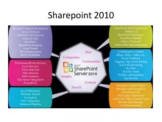
SharePoint 2010and geolocation data FEDSPUG July11th, 2013 Timothy Ferro SharePoint as a Platform for Utilizing and Visualizing Geolocation Data
Agenda • My Background • SharePoint 2010 Composites • Basic Google Map Web Part • Geolocation Web Services • Enhanced Google Map Web Part • Demo • Implementation Options • More Than Just a Map • Questions
My Background • SharePoint Architect / Senior SharePoint Developer • Associate at Booz Allen Hamilton • Event Speaker / Blogger / Tweeter • 5+ Years Architecting and Developing MOSS 2007 and SharePoint 2010 Solutions • timothy.ferro@gmail.com • www.timferro.com • @timferro
Geolocation Web Services • Open Internet • Google Maps • Bing Maps • Multiple geocoding web services • Government Networks • NGA Google Globe • Intelink Fusion Servers • Intelink MetaCarta Web Services • Geocode addresses • Full text scan • MGRS and Lat/Long conversion REST web service
Implementation Options • Web Part • JavaScript only with SPServices and jQuery – code JavaScript in a content editor web part (CEWP) • Custom code hybrid C# and JavaScript – deployable SharePoint web part • Event Receivers on SharePoint Lists • SharePoint Timer Job or Windows Service • Cached Indexed Address Database
More Than Just a Map • SharePoint is a Data Utilization Platform • SharePoint is a Data Visualization Platform • SharePoint is a Development Platform • Real-time Dash-boarding • Data/Trend Analysis • Seamless User Experience
References • SharePoint 2010 as a Platform for Utilizing and Visualizing Geolocation Data (Booz Allen White Paper) • http://sharepoint.microsoft.com/en-us/product/capabilities/composites/Pages/Customize-SharePoint.aspx • timothy.ferro@gmail.com • www.timferro.com • @timferro