Download
1 / 28
280 likes | 408 Vues
This workshop, led by David A. Robinson of Rutgers University, focused on the methodologies and challenges in creating high-quality Climate Data Records (CDRs) for snow and ice observation. Highlighting the use of blended datasets, including NOAA's Interactive Multisensor Snow and Ice Mapping System (IMS) and cooperative microwave products, the session emphasized the importance of scientific stewardship in maintaining data integrity. Key recommendations for NOAA included fostering partnerships and adopting structures that ensure long-term sustainability and accuracy in satellite-based monitoring of climate variability and change.

E N D
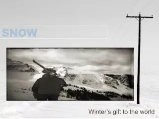
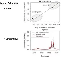
Blended Snow Mapping David A. Robinson Rutgers University EOS Snow and Ice Products User Workshop Landover, MD November 16, 2004
Problems Sensor limitations Inconsistent observation practices over time Relatively short history
Remedy Multiple sources of information - at a given time - over time
Observations used in dataset production • 1. NOAA NH Interactive Multisensor Snow and Ice Mapping System (IMS) snow extent product. • 2. Microwave snow extent and depth product developed in cooperation with Tom Mote (U. Georgia). • Station snow depth observations. Dataset developed in cooperation with Tom Mote.
Rutgers Global Snow Lab http://climate.rutgers.edu/snowcover
Scientific Stewardship Activities Required for the Continued Production of the Climate Data Record Quality control procedures Bias identification and processing Reprocessing “Hands-on” utilization activities
Climate Data Records from Environmental Satellites Presentation to NOAA CCDD ARC meeting August 24, 2004 National Climatic Data Center Asheville, NC THE NATIONAL ACADEMIES Advisors to the Nation on Science, Engineering, and Medicine
Statement of Task • Summarize major needs for and uses of climate data records; • Examine different approaches and strategies for generating CDRs; and • Identify key attributes of examples of successful attempts to create high quality CDRs from satellite data
CDR Committee • David Robinson (Chair), Rutgers University • Roger Barry, University of Colorado/NSIDC • Janet Campbell, University of New Hampshire • Ruth DeFries, University of Maryland, College Park • Bill Emery, University of Colorado • Milton Halem, NASA Goddard Space Flight Center • James Hurrell, National Center for Atmospheric Research • Arlene Laing, University of South Florida • Roberta Miller, Columbia University/CIESIN • Ranga Myneni, Boston University • Richard Somerville, Scripps Institution of Oceanography • Paul Try, Science and Technology Corporation • Tom Vonder Haar, Colorado State University
Overarching Recommendation • NOAA should embrace its new mandate to understand climate variability and change by asserting national leadership for satellite-based Climate Data Record generation, applying new approaches to generate and manage satellite Climate Data Records, developing new community relationships, and ensuring long-term consistency and continuity for a satellite Climate Data Record generation program.
Stewardship of CDRs • NOAA should utilize an organizational structure where a high-level Leadership Council within NOAA receives advice from an Advisory Council that provides input to the process on behalf of the climate research community and other stakeholders. The Advisory Council should be supported by instrument and science teams responsible for overseeing the generation of Climate Data Records. TCDR Teams FCDR Teams Leadership Council Advisory Council
Lessons from the Past • NOAA should build their satellite-based Climate Data Record generation program based on lessons learned from previous attempts, which point out several unique characteristics of satellite Climate Data Records, including the need for continuing calibration, validation, and algorithm refinements, all leading to periodic reprocessing and reanalysis to improve error quantification and reduce uncertainties.
Data Management • NOAA should define satellite Climate Data Record data stewardship policies and procedures that ensure data records and documentation are easily accessible for the current generation and permanently preserved for future generations. 600 500 400 Product Requests (x1000) 300 200 100 0 97 98 99 00 01 02 03
New Community Relationships • NOAA should develop new community relationships by engaging a broader academic community, other government agencies, and the private sector for the development and continuing stewardship of satellite Climate Data Records
Partnerships • NOAA should consider the existing US multi-agency organizations for implementation of the Climate Data Record program, rather than devising a new structure. The most appropriate organization is the Climate Change Science Program.
Resources • NOAA should pursue appropriate financial and human resources to sustain a multi-decadal program focused on satellite Climate Data Records
Thank you http://climate.rutgers.edu/snowcover
Panel contributors • Anne Walker, Climate Research Branch, Meteorological Service of Canada • Merging Satellite-derived and Conventional Datasets for Retrieval of Enhanced SWE Information • Richard Armstrong, National Snow & Ice Data Center, CIRES, U. Colorado • Blending Microwave and Visible Satellite Products for Snow Extent and SWE • Seiji Kato, Center for Atmospheric Sciences, Hampton U. • Estimate of the top-of-atmosphere irradiance over snow and sea ice surfaces • Vincent Salmonson, Earth Sciences Directorate, NASA Goddard Space Flight Center • Comments on Data Fusion Potential in the NPOESS Era