Download
1 / 16
170 likes | 303 Vues
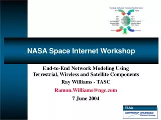
NASA Space Internet Workshop. End-to-End Network Modeling Using Terrestrial, Wireless and Satellite Components Ray Williams - TASC Ramon.Williams@ngc.com 7 June 2004. End-To-End Architecture/Model Methodology. Data Discovery, Storage, Manipulation and Modeling

E N D
NASA Space Internet Workshop End-to-End Network Modeling Using Terrestrial, Wireless and Satellite Components Ray Williams - TASC Ramon.Williams@ngc.com 7 June 2004
End-To-End Architecture/Model Methodology • Data Discovery, Storage, Manipulation and Modeling • Develop Complex End-to-End Architectures in Minutes • Model and Analyze the Complete Environment • Terrestrial • Wireless • Satellite • Analysis and Visualization To Accurately Depict Relationships and Performance • Satellite Tool Kit – Orbital Dynamics with Superior Interactivity • Integrated C4ISR Views with Popkin System Architect • Architecture, Requirements and Schedule • GIS Tools/Methods and Associated Layers • Day/Night Shading • DTED and VMAP Terrain Data • Discrete Event Network Modeling Tools • Network Simulator (ns-2) • Opnet (IT Guru, Modeler)
Data Discovery, Storage, Correlation/Transformation • Terrestrial • Topology and Individual Host Data Obtained from nMap, nTop, Firewalk, Traceroute, tEthereal traces, Circuit Databases, … • Wireless • RF Point-to-Point, Area Coverage Obtained from CSPT, Others • RF Survey Data From Kismet, GPSMap, GPSD, … • Laser Through NWP-ARPS Extensions • Satellite • Orbital Parameters Taken from Two-Line-Element (TLEs), STK Import, … • Requirements • Import of Customer Requirements Documents, DOORS, RequisitePro, AP233
Terrestrial • Based on TCP/IP V4/6 • LAN and WAN Links • Object Based-Extendable
Wireless • Point-to-Point Line-of-Sight • RF and Laser Communications Links • Object-Based Extendable
Satellite • Anything You Can Do In STK, I Can Import • By Using STK We Can Focus On The Communications • Interface Is Object-Based Extendable
STK As A Compute Engine STK with it's Connect and Coverage Modules is Invaluable for Incorporating Satellite Objects into Network Scenarios • Architecture Components Exported to STK via Connect • STK is Commanded to Compute Coverage Times and Orbital Positions • STK Returns Values That Are Stored in a File That is Parsed Using Perl And Those Events Are Inserted into Time-Based Scenario File for Execution
Network Simulator Opnet Our Automated Process End-to-End Model Framework Cellular 802.11 IP Hosts Integrated Statistical Analysis Routes Satellite Tool Kit
Variability in Wireless/Space Communications Figure 1 LEO-TRDSS RF Link Signal Strength
Simulation Modeling “Engines” 1. Spacecraft 2. Orbital & Geolocation 5. Meteorological & Propagation 3. Ground Station 4. RF Spectrum 5. Weather Interference (3 Distinct Thunderstorms ~12 Miles in Height) Weather Models
Integrated Model Output 2. Iridium 13 in Sight - Seattle to Washington Traffic Re-Routing 1. Start of Network 3. Iridium 13 - Out of Sight San Diego to Norfolk Traffic Routed Over Ground 4. No Satellite links up
Acknowledgements • Briefing is Based on the Paper Presented at the 2004 Society of Optical Engineers Conference (SPIE.org) at Orlando, FLA “End-to-End Network Models Encompassing Satellite, Terrestrial and Wireless Components” • Majority of Screenshots Acquired From The TASC Rapid Architecture Development and Evaluation System (TRADES)