Weather Study Guide
Weather Study Guide. Draw windward and leeward. Which side of mountain gets most of rain and which side is desert?. Leeward. Windward. Draw and label the front symbols. What type of weather is associated with each front?. Cold front- cooler weather, thunderstorms

Weather Study Guide
E N D
Presentation Transcript
Draw windward and leeward. Which side of mountain gets most of rain and which side is desert? Leeward Windward
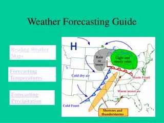
Draw and label the front symbols. What type of weather is associated with each front? • Cold front- cooler weather, thunderstorms • Warm front- warmer, humid, rainy • Stationary front- steady rain • Occluded front- very complex system. May have rain when cold front meets warm front http://www.phschool.com/atschool/phsciexp/active_art/weather_fronts/
4 types of fronts Cold front Warm front Stationaryfront Occluded front
Sea Breeze occur during the day. Warm air over the land is forced upward by cooler, denser air moving inland from the ocean.
Land breezes Occur at night Air over land cools faster than air over the water The cool dense air from the land moves out over the water, pushing the warm air over the water upward.
Air pressure: Force per unit area that is exerted on a surface by the weight of the atmosphere
The variations in air pressure from place to place are the principal cause of
Low pressure systems are usually associated with ______________weather
An air mass that forms over the Gulf of Mexico would be described as
Which front often produces hours of moderate to light precipitation over a large area?
When a hurricane reaches land, its intensity decreases because
The lines on a weather map connecting points of equal atmospheric pressure are called
What is the station model symbol for rain, snow, and thunderstorm?
Which direction do winds in high pressure system blow? Is the pressure high or low in center of high pressure system?
What direction do winds in low pressure system blow? Is the pressure high or low in center of low pressure system?
Isobars that are close together indicate winds that are blowing fast. • Isobars far apart indicate that winds are blowing slow.
Fujita scale measures tornado strength. • What is a weak tornado? F0 • What is a strong tornado? F5
List the air masses and characteristics. Be able to locate on a map.
A very catastrophic hurricane on the Saffir-Simpson scale would be rated- category 5
Label a weather station model for the following conditions for Blacksburg, VA. • Wind speed: 10 knots • Wind direction: S • Barometric Pressure: 950.3 • Cloud Cover: 0% • Dew Point: 15 • Temperature: 53 • Precipitation: none 503 53 15
The Earth’s major climatic zones are polar, temperate, and tropical. Briefly describe each. • Polar: cold, very little vegetation, short, cool summer • Temperate: four seasons, moderate temperatures • Tropical: warm all year, lots of vegetation
List the 4 major factors affecting climate and explain how they affect climate. • Elevation: as elevation increases, the average annual temperature decreases. • Latitude: As latitude increases, the average annual temperature decreases • Proximity to large bodies of water: water is a large reservoir of heat, so water helps regulate climate; cooler summers, warmer winters. • Position relative to mountains: windward (cool, moist) vs leeward (warm, dry) side.
How does the Orographic Effect affect climate? • Windward Side: cool, moist • Leeward Side: warm, dry