Download
1 / 23
230 likes | 370 Vues
Translev Presentation by. Timothy A. Hanson National Geodetic Survey SSMC III, N/NGS41, Rm. 8505 1315 East-West Highway Silver Spring, MD 20910-3282 U S A +1 301-713-3180 X121 Timothy.Hanson@NOAA.gov. Translev Designed by Malcolm R. Archer-Shee mras@friend.ly.net. What is Translev ?.

E N D
Translev Presentation by Timothy A. Hanson National Geodetic Survey SSMC III, N/NGS41, Rm. 8505 1315 East-West Highway Silver Spring, MD 20910-3282 USA +1 301-713-3180 X121 Timothy.Hanson@NOAA.gov
TranslevDesigned by Malcolm R. Archer-Sheemras@friend.ly.net
What is Translev ? • Translev is a computer program that assists in your editing, formatting and checking of raw digital leveling data. Wild/Leica *.raw Zeiss/Trimble *.dat Topcon *.lev
What Does Translev Do? Translev Creates • A master (*.HGZ) file • a booking (*.BOK) and an editable leveling (*.LVL) files • an abstract (*.ABS) file • a VERTOBS datasets for submission to the National Geodetic Survey Translev Includes • many built-in functions such as predicting temperature differences, refraction corrections, rod corrections and level run plotting. • editing routines for “*.LVL” and “VERTOBS” files.
From Start to Finish • Install Translev • Obtain a Level Line (*.DAT, *.GSI, or *.LEV) Data File • Create the (*.HGZ) file within Translev • Translate Raw Level Line Data into the *.LVL Format • Examine the*.LVL File for Errors • Import Additional *.LVL Files & Correct Errors as Needed • Create the Abstract (*.ABS) File • Check VertObs (*.HGZ) Data Set, Remove the Errors • Create Plot & New-Minus-Old • Create Project Report & Transmittal – You Are Done!
Install Translev • The Translev installation program is available from the NGS for free athttp://www.ngs.noaa.gov/PC_PROD/PARTNERS/index.shtmlDownload it!
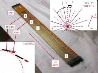
Transfer Data • Move your Digital Data from your Digital Level to your PC Wild/Leica *.raw Zeiss/Trimble *.dat Topcon *.lev
The HGZ File • Create your *.HGZ file! Start Translev: Click File Then New: “L- Number” for the name, store in a directory of your choice.
→ *.LVL *.LEV *.GSI *.DAT • Translate your raw level file into the LVL format
Edit *.LVL Defaults Translev responds by opening an “ Edit Defaults Window ” Add or Correct as needed: Fill in the dialog box. Click “OK” Then Click “Yes”
Edit Out Errors Click “OK” 1 2 3
Import any additional LVL file(s) • Remove errors as necessary (see Edit Out Errors)
Abstract • Create the Abstract • The abstract file contains section running information starting from a previously described bench mark and finishing at the end of the level line. Preliminary field elevations are computed for all bench marks in the level line. The processor can compare section runnings to ensure that they meet NGS specifications for the survey’s order and class. • For leveling specifications see:http://www.ngs.noaa.gov/FGCS/BlueBook/pdf/Chapter6.pdf • Check the Abstract for Rejections
Check VertObs (.HGZ) data set • Correct errors as necessary
Review files for necessary data Simply review all information and data for completeness and accuracy. Make or add all the appropriate changes. Be prepared. The review could be a lengthy process depending upon the size of the project, the number or errors discovered and the types of remedies needed.
All leveling projects must contain a project report prior to submittal. Be sure all processing has been completed as the project report routine will use project information to create the report. The user will be prompted for various items of information to insert in the project report. To the extent possible, the program will supply most of the required information. • Create project report for submittal
You’re Done! • Need Help ? • Translev(Back to the Beginning) ?
The “ F1 ” Key – HELP ! Press F1 and search by Contents, Index or Search string.