Download
1 / 8
90 likes | 382 Vues
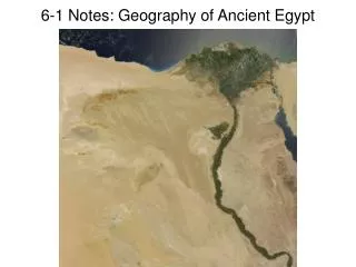
6-1 Notes: Geography of Ancient Egypt. The Nile River. The Nile River is the world ’ s longest river (4,130 miles long!) The Nile flows south to north, so “ Upper ” Egypt is the northern downstream area while “ Lower ” Egypt is the upstream southern area

E N D
The Nile River • The Nile River is the world’s longest river (4,130 miles long!) • The Nile flows south to north, so “Upper” Egypt is the northern downstream area while “Lower” Egypt is the upstream southern area • In the south, the Nile breaks off into two rivers: the White Nile (which begins in Lake Victoria, Uganda) and the Blue Nile (which begins in Lake Tana, Ethiopia)
Why the Nile is important • Much of East Africa has a rainy season that lasts from May to September, which causes the Nile to overflow • This flooding brings water and silt, which turn desert into rich farmland • The Nile breaks into several small branches as it flows into the Mediterranean Sea • Here much of the silt has been deposited over time, forming a delta, a fertile flat land made of silt left behind from a river that flows into a large body of water • Additionally, the Nile acts as a “highway” that allows people to travel and transport goods up and down the river
Egyptians and the Nile • Though Egyptians depended on the water and silt from the Nile, flooding and droughts were still a problem • Egyptian farmers created irrigation systems to control flooding • At first, they only built walls to prevent flooding, but later developed basins, dikes, and canals to control water flow and directly bring it to their farms • Farmers used a bucket-lifter called the shadouf to scoop water from the river for their fields
Seasons of the Nile affect Egypt’s agriculture • In October, flooded land around the Nile begins to dry, so Egyptians planted wheat, barley, cucumbers, lettuce, onions, beans, and flax (used to make cloth) • By March crops were ready for harvest and surpluses were stored in granaries for future use • Harvest time ends in late June before the Nile begins to flood again • During flooding season (late June through September) farmers could not work their fields, so they use this time to travel and visit neighboring villages