Map Study
Map Study. Final Exam. World. Arctic Ocean. International. Arctic Circle. Dateline. Europe. North America. Asia. Tropic of Cancer. Pacific Ocean. Atlantic Ocean. Africa. Equator. Indian Ocean. Prime Meridian. South America. Tropic of Capricorn. Australia. Pacific Ocean.

Map Study
E N D
Presentation Transcript
Map Study Final Exam
World Arctic Ocean International Arctic Circle Dateline Europe North America Asia Tropic of Cancer Pacific Ocean Atlantic Ocean Africa Equator Indian Ocean Prime Meridian South America Tropic of Capricorn Australia Pacific Ocean Antarctic Circle Antarctica
North America Greenland AK Canada Hudson Bay Coast Ranges Great Lakes Interior Plains Appalachians Great Basin Rocky Mountains Great Plains Plains USA Coastal
Latin America G. of Mexico Baja Plateau of Mexico Yucatan Greater Antilles Caribbean Lesser Antilles Panama L. Maracaibo Llanos Andes Galapagos Amazon Basin Brazilian Highlands Andes L. Titicaca Andes Pampas Patagonia Falklands Tierra Del Fuego
Europe Iceland Scandinavia North Sea Baltic Sea British Isles Plain European Rhine English Channel North Danube Alps Danube River Black Sea Iberian Peninsula Mediterranean Sea St. of Gibraltar
Former Soviet Union Bering Sea Kamchatka Pen. North European Plain Sea of Okhostk Siberia Ural Mtns. Volga River L. Baykal Caucasus Aral Sea Caspian Sea
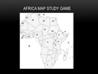
Sub-Saharan Africa El Djouff Nile River Sahel Niger River Chad Basin Sudan Basin Ethiopian Highlands Horn of Africa Congo Basin L. Victoria Rift Valley L. Tanganyika Great Rift Valley Kalahari Basin Cape of Good Hope
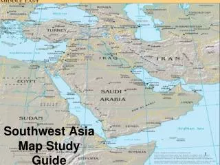
North Africa and the Middle East Bosporus and Dardanelles Hindu Kush Tigris Mesopotamia Atlas Mtns. Euphrates Zagros Mtns. Sahara Ahaggar Mtns. Persian Gulf Sahara Sahara G. of Oman Nile River Rub’ Al Khali Red Sea G. of Aden
Asia, East by South Manchuria Tien Shan Hokkaido N. China Plain Gobi Sea of Japan Korean Peninsula Honshu Tibetan Plateau Yellow Sea Hwang He Chang (Yangtze) Indus East China Sea Brahmaputra Himalayas Ganges Xi Taiwan Deccan Plateau Arabian Sea South China Sea Indochina Bay of Bengal Philippines Sri Lanka Indonesia