Download
1 / 35
350 likes | 371 Vues
Learn about the development and validation of the new GMF for QuikSCAT by Lucrezia Ricciardulli and Frank Wentz at Remote Sensing Systems in Santa Rosa, CA, USA. This model focuses on improving high wind retrievals and combines QuikSCAT data with WindSat to produce a climate data record of ocean vector wind. The validation process includes comparisons with buoys, NCEP data, CCMP, and aircraft measurements, aiming to minimize rain impacts on wind retrievals.

E N D
The New Geophysical Model Function for QuikSCAT: Implementation and Validation Lucrezia Ricciardulli and Frank Wentz Remote Sensing Systems, Santa Rosa, CA, USA Outline: GMF methodology New QSCAT wind speed and direction validation High winds Rain impact Uncertainty maps Acknowledgements This work is supported by NASA Physical Oceanography, Ocean Vector Wind Science Team
Motivation: Why did we need a new GMF? • Despite the demise of QSCAT, QSCAT winds are still used in data assimilation and model reanalyses, research (i.e., cyclones, ENSO), cal/val. • When Ku2001 was developed at RSS (Wentz and Smith, 1999), validation data at high winds were limited. GMF at high winds had to be extrapolated. Analyses showed Ku2001 overestimated high winds. • Our focus has been to improve QSCAT high wind retrievals • Recently, Meissner and Wentz (IEEE TGRS, 2009) developed an algorithm for all-weather WindSat wind retrievals, trained with HRD storms. (See poster by Meissner et al.) • We have confidence in using WindSat wind speeds as ground truth for winds 20-30 m/s. WindSat provides many rain-free high winds observations in extratropics. • Produce a climate data record of ocean vector wind, combining QSCAT with other scatterometers, by using consistent methodology.
The New GMF: Ku2011 The Geophysical Model Function (GMF) relates the observed backscatter ratio s0 to wind speed w and direction j at the ocean’s surface • To develop the new GMF we used 7 years of QSCAT s0 colocated with WindSat wind speeds (90 min) and CCMP (Atlas et al, 2009) wind direction. • WindSat also measures rain rate, used to flag QSCAT s0 when developing GMF • We had hundreds of millions of reliable rain-free colocations, with about 0.2% at winds greater than 20 m/s.
STEP 1: HARMONIC COEFFICIENTS • Minimal smoothing of fit coefficients • Apply correction to A1-A5 for wind direction uncertainty • (similar to Wentz and Smith, 1999) • Decide saturation threshold for A1-A5 coeffs based on visual inspection • A0 does not saturate
STEPS 2 to N: FINE TUNING In this phase, we had numerous productive discussions with the JPL group about what to use for ground truth at high winds. Focus on winds at 30 m/s and below; not enough confidence in ground truth for winds > 30 m/s. Focus only on absolutely rain-free validation winds. Use extratropical high winds for validation, to minimize rain impact. Finalize GMF, but keep open the possibility of adjusting it in the future when new high wind validation data is available. FINE TUNING METHODOLOGY • Adjust A0 coeffs at very high winds to match WindSat in the desired range (20-30 m/s) • Use Ebuchi plots (directional histograms) to diagnose A1, A2 at very low winds and test adjustments • Make sure winds match buoys • Check global wind PDF, no bumps
Ku2011 versus Ku2001 The most significant changes between Ku2001 and Ku2011 are for A0 and A2 coeffs, above 15 m/s. A2 HPOL A0 VPOL
QSCAT VALIDATION: 5 yr statistics, globalComparison with WindSat Ku2001 Ku2011
VALIDATION WITH BUOYS • 200 buoys, global, quality-controlled • Rain-free observations only • 1 hour, 50 km colocations • QSCAT orbital data; 5 yrs Ku2001 Ku2011
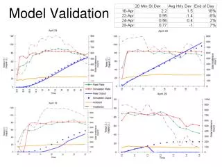
GLOBAL BIAS AND STANDARD DEVIATION:RAIN-FREE QSCAT-VALIDATION WINDS
Regional biases compared to NCEP Ku2001-NCEP Ku2011-NCEP WIND SPEED U V
HIGH WINDS VALIDATION: AIRCRAFT Aircraft turbulent probe observations taken during the Greenland Flow Distortion Experiment (GFDex), Feb and Mar 2007 (Renfrew et al, QJRMS 2009).
HIGH WINDS: GLOBAL MAP QSCAT-WINDSAT Ku2001 Ku2011
DIRECTIONAL HISTOGRAMS: LOW WINDS Two lobes Ku2001 NCEP Ku2011 NCEP
DIRECTIONAL HISTOGRAMS: HIGH WINDS Ku2011 NCEP Ku2001 NCEP
RAIN IMPACT ON WIND RETRIEVALS We used 5 yrs of WindSat wind retrievals in rain to determine statistics of rain impact on QSCAT LOW WINDS POSITIVE BIAS HIGH WINDS NEGATIVE BIAS Ku2001 Ku2011
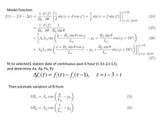
RETRIEVAL UNCERTAINTY: For each cell, with i=1,N observations, the c2 is a measure of the departure of the observed s0 from the GMF using the retrieved wind speed and direction Where var(sobs) represents the measurements’ noise
SUMMARY • QSCAT winds were reprocessed with a new GMF developed with special attention to high winds • WindSat winds used for calibrating GMF. • Multi-year validation QSCAT Ku2011 rain-free winds with global buoys, NCEP, CCMP, aircraft measurements. • Available at www.remss.com . Swath data, and daily, weekly, monthly gridded 0.25-deg maps. • WindSat geophysical products also available on the same website.
FUTURE PLANS • We plan to use similar methodology to develop a new GMF for ASCAT calibrated to WindSat. • Produce a climate-quality ocean vector wind dataset, using QSCAT and ASCAT • Develop an ocean surface stress model function • Analyze and quantify uncertainties in wind retrievals. • We need more validation data at high winds, rain-free, extratropical.
MAPS (aka SOS) QSCAT RAINFLAG + LOW SOS QUALITY FLAG QSCAT RAINFLAG + LOW SOS QUALITY FLAG + WSAT RAINFLAG