Download
1 / 43
430 likes | 454 Vues
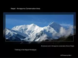
Dive into the captivating world of the Himalayas, one of the youngest mountain ranges. Unveil the history, people, and attractions while exploring adventure activities and serene landscapes. Witness the grandeur of the Himalayan lands and wildlife.

E N D
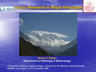
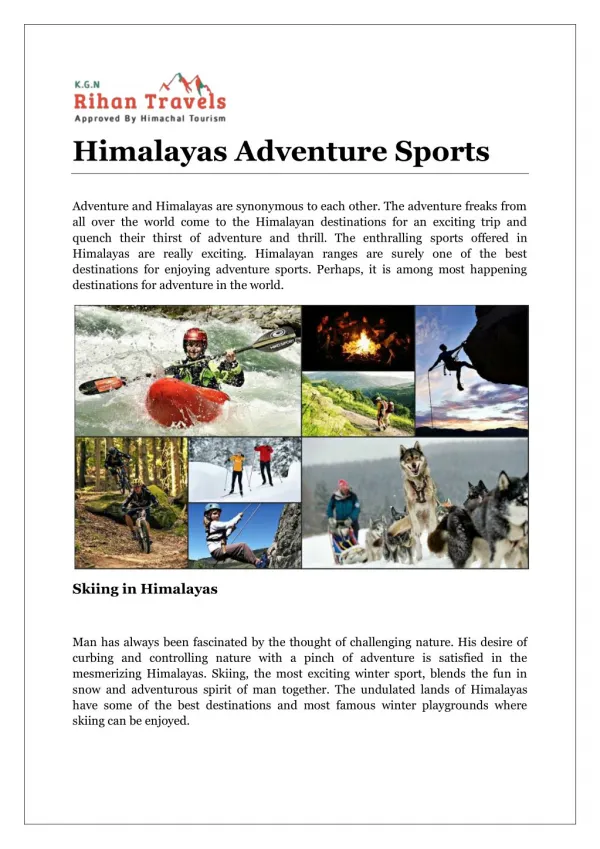
» Dalhousie» Darjeeling» Kathmandu» Ladakh & Leh» Manali» Nainital» Shimla» SrinagarMore..... » Trekking in Himalaya» River Rafting» Mountaineering» Snow Skiing» Camping in Himalayas» Jeep Safari» Hang GlidingMore..... Adventure in Himalayas Himalaya TravelAttraction History of HimalayasHimalayan Mountain RangeClimate of HimalayasThe People & TribesEcotourism in HimalayasThe Himalayan LandsHimalayan Wildlife TravelNational Parks & SanctuariesRivers of HimalayasHimalayan Hill StationsReligions in Himalaya Language Tanslation : Español | Français | Deutsch | Italiano | Português The Himalayas is one of the youngest mountain ranges in the world. Its revolution can be traced to the Jurassic Era (80 million years ago) when the world’s landmasses were split into two: Laurasia in the Northern hemisphere, and Gondwanaland in the southern hemisphere. The landmass which is now India broke away from Gondwanaland and floated across the earth’s surface until it collided with asia. The hard volcanic rocks of India were thrust against the soft sedimentary crust of Asia, creating the highest mountain range in the world. The River System It was a collision that formed mountain ranges right across asia, including the karakoram, the pamirs, the Hindukush, the Tien Shan and the Kun Lun. The Himalayan mountains, at the front of this continental collision, are still being formed, rising and assuming complex profiles. For the ancient geographer, the complexities of this vast mountain range were a constant source of speculation. From the earliest accounts, Mt. Kailash was believed to be the centre of the universe with the River systems of the Indus, the Brahmaputra, and the Sutlej all flowing from its snowy ridges and maintaining the courses which they had followed prior to the forming of the Himalaya.The Sutlej was able to maintain its course flowing directly from Tibet through the main Himalaya range to the Indian subcontinent, while the huge gorges on both flanks of the Himalaya reflect the ability of the Indus and the Brahmaputra to follow their original courses. The Indus flows west until it rounds the Himalaya by the Nanga Parbat Massif, while the Brahmaputra flows eastwards for nearly 1000-kms around the Assam Himalayas and descends to the Bay of Bengal. It was not surprising, therefore, that 19th century geographers experienced formidable difficulties n tracing the River systems, and defining the various mountain ranges that constitute the Himalaya. Even today, with the advent of satellite pictures and state-of-the-art ordnace maps, it is still difficult to appreciate the form and extent of some of the ranges that constitute the Himalaya. Main Himalaya Range This is the principal mountain range dividing the Indian subcontinent from Nanga Parbat in the west, the range stretches for over 2,000-km to the mountains bordering Sikkim and Bhutan in the east. The west Himalaya is the part of this range that divides Kashmir and Himachal Pradesh from Ladakh. The highest mountains here are Nun and Kun. In Kashmir the subsidiary ridges of the Himalaya include the North Sonarmarg, Kolahoi and Amarnath ranges. Further east, the Himalaya extends across to the Baralacha range in Himachal Pradesh before merging with the Parbati range to the east of the Kullu valley. It then extends across kinnaur Kailas to the swargarohini and Bandarpunch ranges in Uttaranchal. Further east it is defined by the snow capped range North of the Gangotri glacier and by the huge peaks in the vicinity of Nanda Devi, the highest mountain in the Indian Himalaya. In Western Nepal the range is equally prominent across the Annapurna and Dhaulagiri massifs, while in Eastern Nepal the main ridgeline frequently coincides with the political boundary between Nepal and Tibet. Major Passes The major passes over the main Himalaya range include the Zoji la, at the head of the Sindh valley; the Boktol pass, at the head of the Warvan valley; the Umasi la in the Kishtwar region; and Thekang la and the Shingo la between Lahaul and the Zanskar region of Ladakh. It also includes the Pin Parbati pass between Lahaul and the Zanskar region of Ladakh. It also includes the Pin Parbati pass between the Kullu valley and Spiti, while in Kinnaur it is traversed when crossing the charang la in the Kinnaur Kailash range.In Uttaranchal, roads are being constructed to the main places of pilgrimage in the heart of the Himalaya. These include Yamunotri and the source of the Yamuna River, Gangotri at the head of the Bhagirathi valley, Kedarnath at the head of the Mandakini valley, and Badrinath in the Alaknanda valley. There are, however, many trekking possibilities across the mountain ridges and glacial valleys including tose bordering the Nanda Devi sanctuary.The main Himalaya range extends east across central Sikkim from the huge Kangchenjunga massif, which includes Kangchenjunga I, the world’s third highest peak. The east Himalaya is breached by the headwaters of the Tista River, which forms the geographical divide between the verdant alpine valleys to the south and the more arid regions that extend North to Tibet. Trekking possibilities are at present confined to the vicinity of the Singali ridge, an impressive range that exxtends south from the main Himalaya and forms the border between India and Nepal.In Darjeeling the treks include the route along the southern extremity of the Singali range, while in Sikkim the trails out of Yuksom explore the ridges and valleys to the south to the Kangchenjunga massif. Pir Panjal Range The Pir Panjal Range lies south of the main Himalaya at an average elevation of 5,000m. From Gulmarg in the North west it follows the southern rim of the Kashmir valley to the Banihal pass. Here the Pir Panjal meets the ridgeline separating the Kashmir valley from the Warvan valley. From Banihal the Pir Panjal sweeps south-east to Kishtwar, where the combined waters of the Warvan and Chandra Rivers meet to form the Chenab River, one of the main tributaries of the Indus.Passes In Pir PanjalThe main passes over the Pir Panjal include the pir panjal pass due west of Srinagar, the Banihal pass which lies at the head of the Jhelum River at the southern end of the Kashmir valley, and the sythen pass linking Kashmir with Kishtwar. In Himachal Pradesh the main passes are the Sach which links the Ravi and the Chandra valleys, and the Rohtang, which links the Beas and Kullu valleys with the upper Chandra valley and Lahaul. Roads are constructed over all these passes. The Banihal is now tunnelled and another road has been made over the Sythen pass in Kashmir and the Sach pass in Himachal Pradesh. For trekkers there is still the attraction of the Kugti, Kalicho and Chobia passes between the Ravi valley and Lahaul, and the Hampta pass links the Kullu valley with Lahaul. Dhaula Dhar Range The Dhaula Dhar range lies to the south of the Pir Panjal. It is easily recognised as the snow-capped ridge behind Dharamsala where it forms the divide between the Ravi and the Beas valleys. To the west it provides the divide between the Chenab valley below Kishtwar and the Tawi valley which twists south to Jammu. This is the range crossed at Patnitop on the Jammu-Srinagar highway. To the east it extends across Himachal Pradesh forming the high ridges of the Largi gorge and extending south of the Pin Parvati valley before forming the impressive ridgeline east of the Sutlej River. Thereon it forms the snow capped divide between the Sangla valley and upper tons catchment area in Uttaranchal, including the Har Ki Dun Valley. Beyond the Bhagirathi River it forms the range between Gangotri and Kedarnath before merging with the main Himalaya at the head of the Gangotri glacier.There are many attractive trekking pases over the Dhaula Dhar. These include the Indrahar Pass North of Dharamsala: and in Kinnaur, the Borasu pass linking the Sangla valley to Har-ki-Dun in Uttaranchal. Siwalik Hills The Siwalik Hills, also known as Shiwalik Hills, lie to the south of the Dhaula Dhar, with an average elevation of 1,500 to 2,000m. They are the first range of hills encountered en route from the plains and are geologically separate from the Himalaya. They include the Jammu hills and Vaishno Devi, and extend to Kangra and further east to the range south of Mandi. In Uttaranchal , they extend from Dehra Dun to Almora before heading across the southern borders of Nepal. Most of the range is crossed by a network of roads, linking the Northern Indian plains with Kangra, the Kullu valley, Shimla and Dehradun. Zanskar Range The Zanskar range lies to the North of the main Himalaya. It forms the backbone of Ladakh south of the Indus River, stretching from the ridges beyond Lamayuru in the west across the Zanskar region, where it is divided from the main Himalaya by the Stod and Tsarap valleys, the populated districts of the Zanskar valley. The Zanskar range is breached where the Zanskar River flows North, creating awesome gorges until it reaches the Indus River just below Leh. To the east of the Zanskar region the range continues through Lahaul & Spiti, providing a complex buffer zone between the main Himalaya and the Tibetan plateau. It continues across the North of Kinnaur before extending west across Uttaranchal, where it again forms the intermediary range between the Himalaya and the Tibetan plateau, which includes Kamet, the second highest peak in India. The range finally peters out North east of the Kali River - close to the border between India and Nepal.On the Zanskar range, the Fatu La, on the Leh-Srinagar road, is considered the most easterly pass; while the Singge La, the Cha Cha La and the Rubrang La are the main trekking passes into the Zanskar valley. For the hardy Ladakh trader, the main route in winter between the Zanskar valley and Leh is down the icebound Zanskar River gorges. Further to the east, many of the Zanskar range passes to the North of Spiti and Kinnaur are close to the India-Tibet border, and are closed to Trekkers Ladakh Range The ladakh range lies to the North of Leh and is an integral part of the Trans-Himalayan range that merges with the Kailash range in Tibet. The passes include the famous Kardung La, the highest motorable pass in the world, while the Digar La to the North east of Leh is at present the only pass open to trekkers.. East Korakoram Range The East Karakoram Range is the huge range that forms the geographical divide between India and Central Asia. It includes many high peaks including - Teram Kargri, Saltoro Kangri and Rimo, while the Karakoram Pass was the main trading link between the markets of Leh, Yarkand and Kashgar. At present this region is closed to trekkers, although a few foreign mountaineering groups were permitted to climb there in the last decade. (* represents compulsory fields)
» Dalhousie» Darjeeling» Kathmandu» Ladakh & Leh» Manali» Nainital» Shimla» SrinagarMore..... » Trekking in Himalaya» River Rafting» Mountaineering» Snow Skiing» Camping in Himalayas» Jeep Safari» Hang GlidingMore..... Adventure in Himalayas Himalaya TravelAttraction History of HimalayasHimalayan Mountain RangeClimate of HimalayasThe People & TribesEcotourism in HimalayasThe Himalayan LandsHimalayan Wildlife TravelNational Parks & SanctuariesRivers of HimalayasHimalayan Hill StationsReligions in Himalaya Language Tanslation : Español | Français | Deutsch | Italiano | Português The Himalayas is one of the youngest mountain ranges in the world. Its revolution can be traced to the Jurassic Era (80 million years ago) when the world’s landmasses were split into two: Laurasia in the Northern hemisphere, and Gondwanaland in the southern hemisphere. The landmass which is now India broke away from Gondwanaland and floated across the earth’s surface until it collided with asia. The hard volcanic rocks of India were thrust against the soft sedimentary crust of Asia, creating the highest mountain range in the world. The River System It was a collision that formed mountain ranges right across asia, including the karakoram, the pamirs, the Hindukush, the Tien Shan and the Kun Lun. The Himalayan mountains, at the front of this continental collision, are still being formed, rising and assuming complex profiles. For the ancient geographer, the complexities of this vast mountain range were a constant source of speculation. From the earliest accounts, Mt. Kailash was believed to be the centre of the universe with the River systems of the Indus, the Brahmaputra, and the Sutlej all flowing from its snowy ridges and maintaining the courses which they had followed prior to the forming of the Himalaya.The Sutlej was able to maintain its course flowing directly from Tibet through the main Himalaya range to the Indian subcontinent, while the huge gorges on both flanks of the Himalaya reflect the ability of the Indus and the Brahmaputra to follow their original courses. The Indus flows west until it rounds the Himalaya by the Nanga Parbat Massif, while the Brahmaputra flows eastwards for nearly 1000-kms around the Assam Himalayas and descends to the Bay of Bengal. It was not surprising, therefore, that 19th century geographers experienced formidable difficulties n tracing the River systems, and defining the various mountain ranges that constitute the Himalaya. Even today, with the advent of satellite pictures and state-of-the-art ordnace maps, it is still difficult to appreciate the form and extent of some of the ranges that constitute the Himalaya. Main Himalaya Range This is the principal mountain range dividing the Indian subcontinent from Nanga Parbat in the west, the range stretches for over 2,000-km to the mountains bordering Sikkim and Bhutan in the east. The west Himalaya is the part of this range that divides Kashmir and Himachal Pradesh from Ladakh. The highest mountains here are Nun and Kun. In Kashmir the subsidiary ridges of the Himalaya include the North Sonarmarg, Kolahoi and Amarnath ranges. Further east, the Himalaya extends across to the Baralacha range in Himachal Pradesh before merging with the Parbati range to the east of the Kullu valley. It then extends across kinnaur Kailas to the swargarohini and Bandarpunch ranges in Uttaranchal. Further east it is defined by the snow capped range North of the Gangotri glacier and by the huge peaks in the vicinity of Nanda Devi, the highest mountain in the Indian Himalaya. In Western Nepal the range is equally prominent across the Annapurna and Dhaulagiri massifs, while in Eastern Nepal the main ridgeline frequently coincides with the political boundary between Nepal and Tibet. Major Passes The major passes over the main Himalaya range include the Zoji la, at the head of the Sindh valley; the Boktol pass, at the head of the Warvan valley; the Umasi la in the Kishtwar region; and Thekang la and the Shingo la between Lahaul and the Zanskar region of Ladakh. It also includes the Pin Parbati pass between Lahaul and the Zanskar region of Ladakh. It also includes the Pin Parbati pass between the Kullu valley and Spiti, while in Kinnaur it is traversed when crossing the charang la in the Kinnaur Kailash range.In Uttaranchal, roads are being constructed to the main places of pilgrimage in the heart of the Himalaya. These include Yamunotri and the source of the Yamuna River, Gangotri at the head of the Bhagirathi valley, Kedarnath at the head of the Mandakini valley, and Badrinath in the Alaknanda valley. There are, however, many trekking possibilities across the mountain ridges and glacial valleys including tose bordering the Nanda Devi sanctuary.The main Himalaya range extends east across central Sikkim from the huge Kangchenjunga massif, which includes Kangchenjunga I, the world’s third highest peak. The east Himalaya is breached by the headwaters of the Tista River, which forms the geographical divide between the verdant alpine valleys to the south and the more arid regions that extend North to Tibet. Trekking possibilities are at present confined to the vicinity of the Singali ridge, an impressive range that exxtends south from the main Himalaya and forms the border between India and Nepal.In Darjeeling the treks include the route along the southern extremity of the Singali range, while in Sikkim the trails out of Yuksom explore the ridges and valleys to the south to the Kangchenjunga massif. Pir Panjal Range The Pir Panjal Range lies south of the main Himalaya at an average elevation of 5,000m. From Gulmarg in the North west it follows the southern rim of the Kashmir valley to the Banihal pass. Here the Pir Panjal meets the ridgeline separating the Kashmir valley from the Warvan valley. From Banihal the Pir Panjal sweeps south-east to Kishtwar, where the combined waters of the Warvan and Chandra Rivers meet to form the Chenab River, one of the main tributaries of the Indus.Passes In Pir PanjalThe main passes over the Pir Panjal include the pir panjal pass due west of Srinagar, the Banihal pass which lies at the head of the Jhelum River at the southern end of the Kashmir valley, and the sythen pass linking Kashmir with Kishtwar. In Himachal Pradesh the main passes are the Sach which links the Ravi and the Chandra valleys, and the Rohtang, which links the Beas and Kullu valleys with the upper Chandra valley and Lahaul. Roads are constructed over all these passes. The Banihal is now tunnelled and another road has been made over the Sythen pass in Kashmir and the Sach pass in Himachal Pradesh. For trekkers there is still the attraction of the Kugti, Kalicho and Chobia passes between the Ravi valley and Lahaul, and the Hampta pass links the Kullu valley with Lahaul. Dhaula Dhar Range The Dhaula Dhar range lies to the south of the Pir Panjal. It is easily recognised as the snow-capped ridge behind Dharamsala where it forms the divide between the Ravi and the Beas valleys. To the west it provides the divide between the Chenab valley below Kishtwar and the Tawi valley which twists south to Jammu. This is the range crossed at Patnitop on the Jammu-Srinagar highway. To the east it extends across Himachal Pradesh forming the high ridges of the Largi gorge and extending south of the Pin Parvati valley before forming the impressive ridgeline east of the Sutlej River. Thereon it forms the snow capped divide between the Sangla valley and upper tons catchment area in Uttaranchal, including the Har Ki Dun Valley. Beyond the Bhagirathi River it forms the range between Gangotri and Kedarnath before merging with the main Himalaya at the head of the Gangotri glacier.There are many attractive trekking pases over the Dhaula Dhar. These include the Indrahar Pass North of Dharamsala: and in Kinnaur, the Borasu pass linking the Sangla valley to Har-ki-Dun in Uttaranchal. Siwalik Hills The Siwalik Hills, also known as Shiwalik Hills, lie to the south of the Dhaula Dhar, with an average elevation of 1,500 to 2,000m. They are the first range of hills encountered en route from the plains and are geologically separate from the Himalaya. They include the Jammu hills and Vaishno Devi, and extend to Kangra and further east to the range south of Mandi. In Uttaranchal , they extend from Dehra Dun to Almora before heading across the southern borders of Nepal. Most of the range is crossed by a network of roads, linking the Northern Indian plains with Kangra, the Kullu valley, Shimla and Dehradun. Zanskar Range The Zanskar range lies to the North of the main Himalaya. It forms the backbone of Ladakh south of the Indus River, stretching from the ridges beyond Lamayuru in the west across the Zanskar region, where it is divided from the main Himalaya by the Stod and Tsarap valleys, the populated districts of the Zanskar valley. The Zanskar range is breached where the Zanskar River flows North, creating awesome gorges until it reaches the Indus River just below Leh. To the east of the Zanskar region the range continues through Lahaul & Spiti, providing a complex buffer zone between the main Himalaya and the Tibetan plateau. It continues across the North of Kinnaur before extending west across Uttaranchal, where it again forms the intermediary range between the Himalaya and the Tibetan plateau, which includes Kamet, the second highest peak in India. The range finally peters out North east of the Kali River - close to the border between India and Nepal.On the Zanskar range, the Fatu La, on the Leh-Srinagar road, is considered the most easterly pass; while the Singge La, the Cha Cha La and the Rubrang La are the main trekking passes into the Zanskar valley. For the hardy Ladakh trader, the main route in winter between the Zanskar valley and Leh is down the icebound Zanskar River gorges. Further to the east, many of the Zanskar range passes to the North of Spiti and Kinnaur are close to the India-Tibet border, and are closed to Trekkers Ladakh Range The ladakh range lies to the North of Leh and is an integral part of the Trans-Himalayan range that merges with the Kailash range in Tibet. The passes include the famous Kardung La, the highest motorable pass in the world, while the Digar La to the North east of Leh is at present the only pass open to trekkers.. East Korakoram Range The East Karakoram Range is the huge range that forms the geographical divide between India and Central Asia. It includes many high peaks including - Teram Kargri, Saltoro Kangri and Rimo, while the Karakoram Pass was the main trading link between the markets of Leh, Yarkand and Kashgar. At present this region is closed to trekkers, although a few foreign mountaineering groups were permitted to climb there in the last decade. (* represents compulsory fields)
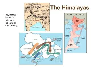
FORMATION OF HIMALAYAS • Among the most dramatic and visible creations of plate-tectonic forces are the lofty Himalayas, which stretch 2,900 km along the border between India and Tibet. This immense mountain range began to form between 40 and 50 million years ago, when two large landmasses, India and Eurasia, driven by plate movement, collided. Because both these continental landmasses have about the same rock density, one plate could not be subducted under the other. The pressure of the impinging plates could only be relieved by thrusting skyward, contorting the collision zone, and forming the jagged Himalayan peaks.About 225 million years ago, India was a large island still situated off the Australian coast, and a vast ocean (called Tethys Sea) separated India from the Asian continent. When Pangaea broke apart about 200 million years ago, India began to forge northward. By studying the history -- and ultimately the closing-- of the Tethys, scientists have reconstructed India's northward journey. About 80 million years ago, India was located roughly 6,400 km south of the Asian continent, moving northward at a rate of about 9 m a century. When India rammed into Asia about 40 to 50 million years ago, its northward advance slowed by about half. The collision and associated decrease in the rate of plate
The oldest landmass was a part of the Gondwanaland ( India, Australia, South Africa and South America) The convectional currents split the crust into number of pieces, thus drifting of the Indo-Australian plate after being separated from the Gondwanaland, towards North. The northward drift resulted in the collision of plate with the much larger Eurosian plate. Due to this collision the sedimentary rocks which were accumulated in the geosyncline known as the Tethys were folded to form the Himalaya mountain. FORMATION OF NORTHERN PLAINS- Himalaya uplift out of Tethys sea and subsidence of the northern flank of peninsular plateau resulted in the formation of a large basin. In the course of time this depression, gradually got filled with deposition of sedimentation by the rivers flowing from the mountians in the north and the plateau in the south. A flat land of extensive alluvial deposits led to the formation of the northern plains of India. Formation of Himalaya
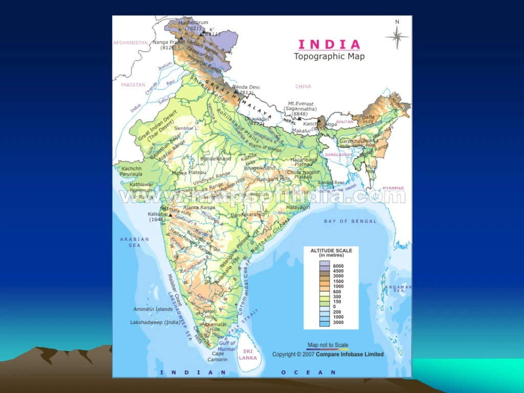
The Himalayan Mountain • Ext. – From Kashmir to Arunachal Pradesh. (Indus – Brahmaputra) • Length- 2500 km Width- 150-400 km • Three ranges of Himalaya • 1. The Great or Inner Himalaya or Himadari • # Most continuous • # Consisting of loftiest peaks with average height of 6000m.
SOME HIGHEST PEAKS • Kanchanjunga – India – 8598m • Makalu – Nepal – 8481m • Dhaulagiri - Nepal – 8172m • Nanga Parbat India - 8176m • Annapurna Nepal – 8078m • Nanda Devi India - 7817m • Kamet India - 7756 • Namcha Bharwa India – 7756 • Gurla Mandhata Nepal - 7728
Features • The folds are asymmetrical in nature • Core is made up of granite • Perennially snow bound • A number of glaciers
Most rugged mountain system Altitude – 3700-4500m Width – 50 km Longest range – The Pir Panjal Other ranges-The Dhaula Dhar and The Mahabharat. Valleys- Kashmir, the Kangra and Kullu HIMACHAL RANGE
SHIWALIK RANGE • Altitude – 900-1100m • Width – 10-50 Km • Composed of unconsolidated sediments brought down by rivers from main Himalayan ranges. • These valleys are covered with thick gravel and alluvium. • Longitudinal valley lying between lesser Himalayas and Shiwalik is known as dun. • Eg. Dehra Dun, Patli Dun and Kotli Dun.
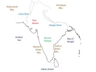
Division of Himalayas • Division of Himalayas on the basis of region from west to east- • Part of Himalayas lying between Indus and Satluj – Punjab Himalaya- Kashmir and Himachal Himalaya • Between Satluj and Kali – Kumaon Himalaya • Between Kali and Tista – Nepal Himalaya • Between Tista and Dihang – Assam Himalaya • Eastern most boundary – Brahamaputra
Purvanchal or The Eastern hill or mountains • Running through the north-eastern states • Composed of strong sandstone • Covered with dense forest • Parallel ranges and valleys • Patkai hills, Naga Hills, Manipur hills, Mizo hills
HOW IT IS FORMED • By interplay of the Ganga,the Brahmaputra and the Indus. • Formed of alluviul soil • Area – 7 lakh sq.km. • Length – 2400 km • Width – 240-320 km • Adequate water supply, favourable climate • Many riverine islands are formed in the lower course due to less velocity.
THREE SECTIONS • 1. PUNJAB PLAIN – western part – formed by Indus and its tributaries. • Large part of this plain- in Pakistan which is formed by Indus and its tributaries – The Jhelum, the Ravi, The Beas etc. • This part is dominated by Doab DIVISION OF GREAT PLAIN
2. GANGA PLAIN- Extends between Ghaggar and Teesta river It covers Haryana, Delhi, U.P., Bihar, partly Jharkhand . 3. BRAHMAPUTRA PLAIN- In Assam Note- These vast plains have various relief features. According to variations in relief features the Northern Plains can be divided into 4 regions.
1. Bhabar Belt- Lying parallel to the slopes of the Shiwalik • Width- 8-16 Km, a narrow belt of pebbles • All the streams disappear in this belt. • 2. Terai – South of Bhabar, the streams and rivers re-emerge and create a wet swampy and marshy region. This was thickly forested. • Dudhwa National Park in this region.
3. Bhangar – Formed of older alluvium • Lie above the flood plains of the rivers and present a terrace like feature. • Here soil contains calcareous (kankar) • 4. Khadar – The newer, younger deposits o fthe flood plains are called Khadar. • They are renewed every year so ideal for intensive agriculture.
THE PENINSULAR PLATEAU • A tableland of the crystalline, igneous and metamorphic rocks. • Formed due to the breaking and drifting of the Gondwana land. • Has broad and shallow valleys and rounded hills. • The Narmada valley divides it into 2 parts – The Central Highland in the North and the Deccan Plateau in the South.
It has three parts- Malwa Plateau, the small plateau of Bundelkhand and the Chotanagpur plateau. In South – The Vindhyan range In Northwest – The Aravalis Westward – desert Important rivers- the Chambal, the Sind, the Betwa and Ken – from southwest to northeast. Wider in west and narrower in the east. CENTRAL HIGHLANDS
DECCAN PLATEAU • This triangular landmass lies to the south of the river Narmada. • North- Satpura range • East – The Mahadev, the Kaimur hills and the Maikal hills. • Higher in the west and slopes eastward • Other names – The Meghalaya, Karbi-Anglong and North Cachar
THE 2 GHATS Mark the western and eastern edges of the Deccan Plateau. • Western Ghats - lie the parallel to the western coast. • They are continuous and can be crossed through passes only. • Average elevation- 900-1600 it increases from north to south. • They cause orographic rain by facing the moist winds to rise along western slopes. • Anai Mudi(2695m) and Doda Beta(2637) are the highest peaks. • Shevroy Hills and the Javedi Hills- Southeast of the Eastern Ghats.
EASTERN GHATS- • They stretch from Mahanadi valley to the Nilgiris in south. • They are discontinuous and irregular and dissected by rivers draining into Bay of Bengal. • Mahendragiri (1501m) is the highest peak.
LAKSHADWEEP- (1973) LYING CLOSE TO MALABAR COAST OF KERALA COMPOSED OF SMALL CORAL ISLANDS OTHER NAMES- LACCADIVE, MINICOY AND AMINDIVE AREA- 32 sq km. Adm. Headquarters- Kavaratti Great diversity of flora and fauna Pitti island – bird sanctuary ISLANDS
ANDAMAN AND NICOBAR ISLAND • LOCATION- Bay of Bengal • These are an elevated portion of submarine portion • Has equatorial climate and variety of flora and fauna.
INDIAN DESERT • LOCTION- Western margins of the Aravali Hills. • Covered with sand dunes. • Rain fall- 150 mm • Arid climate – low vegetation. • Seasonal rivers. • Luni- large river • Barchans( crescent shaped dunes)- Jesalmer • Longitudinal dunes are near Indo-Pakistan Boundary.