3-5 March 2003 Ispra, Italy
230 likes | 374 Vues
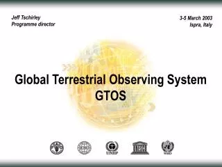
Jeff Tschirley Programme director. 3-5 March 2003 Ispra, Italy. Global Terrestrial Observing System GTOS. GTOS mission. Facilitate access to information on terrestrial ecosystems. Activities that seek to detect, understand and manage change.

3-5 March 2003 Ispra, Italy
E N D
Presentation Transcript
Jeff Tschirley Programme director 3-5 March 2003 Ispra, Italy Global Terrestrial Observing System GTOS
GTOS mission • Facilitate access to information on terrestrial ecosystems. • Activities that seek to detect, understand and manage change. • Products of known accuracy to researchers and policy makers. • Work with countries to develop global, continental, regional products.
GTOS programme Characteristics of activities • Produce validated data and information products with known accuracies • Stimulate advances in the assembly, use, management and exchange of large terrestrial datasets • Promote common data processing standards and interpretation methods • Support systems that provide both research and operational information on a regular and sustained basis • Strengthen links between satellite and in situ data; in particular the international conventions • Identify gaps and overlaps in current and planned earth observation programs; find ways to resolve them
GTOS programme Areas of concentration • Terrestrial climate observations (TOPC) • Terrestrial carbon observations (TCOP) • Forest and land cover dynamics (GOFC-GOLD) • Terrestrial ecosystem monitoring sites (TEMS) • Terrestrial – coastal observations (C-GTOS)
Terrestrial carbon observations • Hierarchy of spatial scales • Dual-constraint approach • Predictions are compared to estimates made from observations • Estimate regional fluxes and uncertainties Principles
GOOS ten-year plan for in-situ observations 2001 2002 2000 2003 2004 2005 2006 2007 2008 2009 2010 Operational GPS/DORIS stations 86 86 86 86 86 80 55 Tide gauges 45 45 40 40 1250 1250 1250 1250 1250 779 810 807 671 1250 Number of buoys 1050 Surface drifting buoys 94 99 99 99 83 87 90 Number of moorings 79 79 77 77 Tropical moored buoys High resolution and frequently repeated lines occupied 41 41 41 41 36 32 Ships of opportunity 29 26 26 24 23 3000 3000 3000 3000 3000 3000 544 200 310 Argo floats Number of floats 2000 1000 29 29 29 29 10 1 7 6 2 Reference stations Number of flux moorings 16 14 150 150 150 120 Moorings with climate sensors 40 Coastal moorings 0 15 0 0 0 80 Number of flux sites/lines, One inventory per 10 years 38 40 40 40 36 20 18 16 14 32 Ocean carbon network 24 820 820 820 760 700 670 Dedicated ship time Days at sea (NOAA contribution) 430 250 250 250 250 Product evaluation and feedback loops implemented 9 10 10 3 4 System evaluation 0 1 1 1 7 6 100 100 99 94 88 44 40 34 30 Total system 77 System % complete 48 2001 2002 2000 2003 2004 2005 2006 2007 2008 2009 2010
C-GTOS 1 A long-term global coastal observing system. Near-term products that demonstrate value. Greenville achievements DPSR framework development Phenomena of global interest Identification of variables, parameters Initial product definition
C-GTOS 2 Still to address • Satellite-based observations • Product priorities (e.g. shoreline characterization, Tems) • Data and information management • Education, capacity building, training, communication • Links with other groups, partnerships • Integration of ocean and terrestrial
C-GTOS 3 To do … in 2003 … and beyond • March : Second C-Gtos meeting • April / May : Drafting of C-Gtos plan • May – November : TEMS module development • June : Igos partner meeting coastal theme (C-Gtos report) • July / August / September : Review, revision of C-Gtos plan • November : Igos partner meeting • Late 2003? : Last C-Gtos plan meeting • Early 2004 : Finalization of C-Gtos implementation plan
GTOS programme Structure
GTOS programme • Changes in land quality • Availability of freshwater resources • Loss of biodiversity • Climate change • Pollution and toxicity Key issues
Terrestrial climate observations • How is the global climate system changing? • What are the primary factors forcing the climate system? TOPC science questions
Terrestrial climate observations Technical training • Defining terrestrial observations and methods to: • Characterize current climate • Determine rate and causes of change • Forcing and feedbacks from changing GHG concentrations • Predictive, use in assimilation models: • What to observe, when, where and at what accuracy • Generating products to understand and predict climate processes • Reporting to UNFCCC on adequacy of global observing systems (terrestrial component) Observations and modelling
Terrestrial carbon observations • 2005: estimate annual net land-atmosphere fluxes at a sub-continental scale with a 30% accuracy globally and spatial resolution (106 km2 regionally) • 2008: improve accuracy (20%) and spatial resolution (106 km2 globally) • Produce sink/source maps with the highest spatial resolution enabled by the available satellite-derived and other input products (~ 1 km2 or less) An IGOS initiative with the following objectives
Terrestrial carbon observations • 2005: estimate annual net land-atmosphere fluxes at a sub-continental scale with a 30% accuracy globally and a regional scale (106 km2) • 2008: improve spatial resolution (106 km2 globally) and accuracy (20%) • Produce sink/source maps with the highest spatial resolution enabled by the available satellite-derived and other input products (~ 1 km2 or less) An IGOS initiative led by GTOS
Terrestrial carbon observations • Satellite: land cover and use, biomass, leaf area, fires, solar radiation, atmospheric column (CO2, CH4) • Atmospheric: near surface GHG concentration, surface fluxes • In Situ: Carbon pools and changes Key observation requirements
Forest and land cover dynamics • Forest and land cover characteristics and change • Fire monitoring and mapping • Biophysical processes GOFC-GOLD teams
Forest and land cover dynamics • Operational forest and land cover monitoring system • Improved satellite and in situ validation • Strengthening regional networks • Central and southern Africa • Southeast Asia • Boreal zones Next steps
Terrestrial Ecosystem Monitoring Sites Web directory of 1,600 sites and 55 networks in 110 countries that carry out long-term terrestrial ecosystem monitoring of 110 variables Who, what, where http://www.fao.org/gtos/tems
Global observation networks • Build international collaboration • Improve communication : scientific and with decision-making community Key challenges Current networks Hydrology, Glaciers, Permafrost, Mountains
Questions and answers GTOS Secretariat www.fao.org/gtos gtos@fao.org tel: +39 06 5705-2565 fax: +39 06 5705-3369