The Hydrosphere
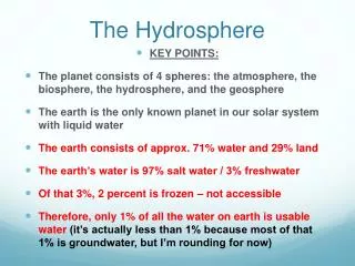
The Hydrosphere. Observatory textbook pages 200 to 213. ST EST AST ES. 2. The Hydrosphere. The hydrosphere consists of the Earth’s water resources: oceans, lakes, rivers, streams, groundwater, and glaciers 97.5% of water on Earth is salt water Only 2.5% is freshwater!

The Hydrosphere
E N D
Presentation Transcript
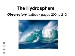
The Hydrosphere Observatory textbook pages 200 to 213 ST EST AST ES
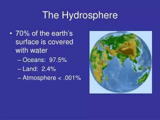
2. The Hydrosphere • The hydrosphereconsists of the Earth’s water resources: oceans, lakes, rivers, streams, groundwater, and glaciers • 97.5% of water on Earth is salt water • Only 2.5% is freshwater! • Fig. 6.26 on p. 201 ST EST AST ES
ST EST AST ES
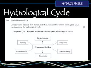
2.1 Inland Waters • Inland waters are all the freshwater resources found on the continents (lakes, rivers, groundwater) • A watershedis an area of land in which all inland waters drain into the same larger body of water (also called catchment area or drainage basin) • eg: St.Lawrence River watershed ST EST AST
What is a watershed? ST EST AST
St. Lawrence River Watershed ST EST AST
Factors that affect how water flows within a watershed • Topography slope of the land; steep slopes drain easily and quickly • Geology type of rock; holes or gaps in rock vs. compact clay • Climate rainfall, winds and temperature • Vegetation highly vegetated areas can slow water flow • Development a dam can prevent water from flowing freely ST EST AST
2.2 The Oceans • Five major oceans • Pacific Ocean • Atlantic Ocean • Arctic Ocean • Indian Ocean • Southern Ocean (as of 2000) ** Two important factors when studying oceans are temperature and salinity ST EST
Ocean Temperature • Ocean temperature varies with depth, season and latitude ST EST
Depth • Sunlight warms the top layer of ocean water which is called the mixed layer • Below 200m temperature drops quickly; this zone of rapid temperature change is called the thermocline • Beneath the thermocline at about 1000m, water temperatures are uniformly cold at about 4oC ST EST
Ocean Temperature and Depth ST EST
Season • Oceans warm slightly in summer and cool slightly in winter. • The changes in temperature are less pronounced than on the land because water loses or gains heat much more slowly than land. ST EST
Latitude • Ocean waters are 25oC to 28oC at the equator and only 12oC to 17oC in the temperate zones. • They are colder still at extreme northern and southern latitudes (<10oC). ST EST
Ocean Salinity • Salts dissolved from the lithosphere create a salty ocean. These salts dissolve as rivers flow over the ground and empty into the ocean. • Salinity is a measure of the amount of salt dissolved in a liquid. • Ocean salinity is about 3.4 to 3.7% ST EST
Ocean Circulation • Water in the ocean is in constant motion. • An ocean current is the movement of seawater in a certain direction. • Ocean circulation is the combined effect of all currents that move in oceans. ST EST
Surface Currents • Wind driven ocean currents • Push the top 400m of water • eg: The Gulf Stream current • See map diagram on p. 204-205 of Observatory ST EST
Ocean surface currents ST EST
Subsurface Currents • Occur at depths of more than 800m • Due to variations in density between layers of water • Cold water is more dense and tends to sink • High salinity water is also more dense and sinks below less saline water ST EST
Thermohaline Circulation • The combined effect of surface and subsurface currents is termed thermohaline circulation • Results in water being moved all around the globe • Accounts for major transfers of heat • Dramatically affects global weather patterns ST EST
2.3 The Cryosphere • The cryosphereis all the frozen water on the surface of the earth (pack ice, glaciers, frozen lakes, permafrost). ST EST
Pack Ice • Composed of the ice floating on the oceans near the North and South poles • Extent of pack ice changes with seasons • Due to the effect of global warming the extent of pack ice is shrinking ST EST
Glaciers • A glacier is a mass of ice on land, formed by compressed snow • Contain 79% of world’s freshwater • Largest glaciers are at the poles (eg: Greenland icecap), but some smaller glaciers exist in mountain ranges (eg: in BC and Alberta) • Glaciers are also melting at a fast rate due to global warming • The melting of glaciers and pack ice may lead to a rise in sea level and consequent flooding of low lying lands (eg: Florida) ST EST
A high alpine glacier ST EST
2.4 Energy Resources from the Hydrosphere • Hydraulic energy energy derived from moving water • Three main sources of hydraulic energy: rivers, waves and ocean currents ST EST AST
Hydroelectric Dams • Convert a river’s hydraulic energy into electrical power • Quebec derives almost all of its electricity from hydro dams • Water flowing through the dam’s turbine creates electricity which is then distributed to cities and factories. • Produce little greenhouse gases, but cause large areas of flooding upstream of the dam • This flooding, in turn, can release toxic mercury into the environment ST EST AST
James Bay Hydroelectric Dam ST EST AST
Waves and Ocean Currents • Buoys that rise and fall with the waves can be attached to turbines to create electrical energy • Underwater turbines can harness ocean current energy much the same way a windmill operates • Most of these ideas are still in the prototype stage ST EST AST
2.5 Pollution and Degradation of Water Resources • Chemical pollution metals, mercury, PCB’s, mine drainage • Thermal pollution heat discharge from factories can decrease oxygen content and lead to fish kills • Oil spills 6 million tonnes per year • Plastics north Pacific Gyre an ocean “garbage dump” EST SE
Fish Kill EST SE
Oil Spills EST SE
North Pacific Trash Gyre EST SE
Eutrophication • Farming activities add excess fertilizers to rivers and lakes (mostly phosphorus and nitrogen). • These excess fertilizers can stimulate algae growth. • Excess algae growth can then lead to algae blooms, toxins being produced, reduced oxygen levels, fish kills and green scum forming on lakes. • This whole process is called eutrophication. EST ES
Eutrophication EST ES
Eutrophication experiment conducted by the University of Manitoba.Can you guess to which side of the lake fertilizer was added? EST ES
Hydrosphere Review • Answer questions 20 to 36 on pages 215-216. • Use your notes and refer to pages 200 to 213 in Observatory to guide you in your answers. ST EST AST ES