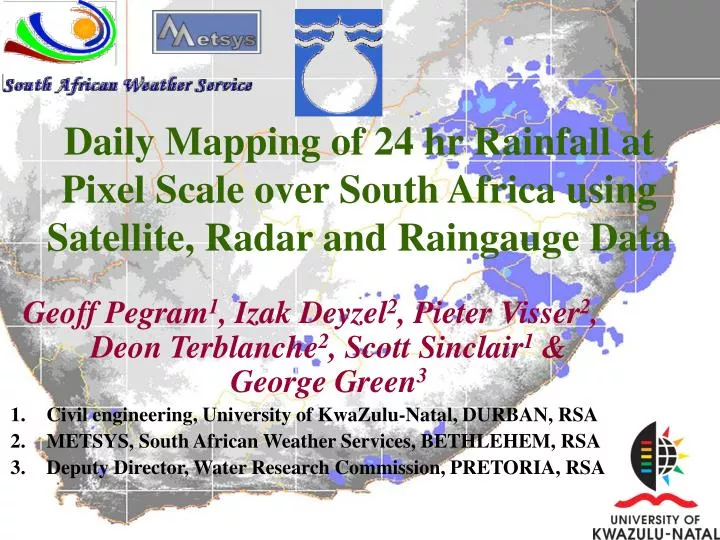

Daily Mapping of 24-hr Rainfall in South Africa
E N D
Presentation Transcript
Daily Mapping of 24 hr Rainfall at Pixel Scale over South Africa using Satellite, Radar and Raingauge Data Geoff Pegram1, Izak Deyzel2, Pieter Visser2, Deon Terblanche2, Scott Sinclair1 & George Green3 Civil engineering, University of KwaZulu-Natal, DURBAN, RSA METSYS, South African Weather Services, BETHLEHEM, RSA Deputy Director, Water Research Commission, PRETORIA, RSA
Presentation Overview • Objectives • Satellite information as a data source • Producing a satellite rainfall map for South Africa • Validation of Satellite Rainfall Fields • Use Gauge and Radar information to augment • Producing the Merged Rainfall Field • Verification of the Merged Rainfall Fields • How do we improve the product? • A spin-off is the ground-truthing of satellite data
Objectives South Africa has limited resources: • Sparse raingauge network • Patchy C-band radar coverage (non-Doppler) SO … • Use Satellite data to derive a Daily Rainfall Field over South Africa at highest spatial resolution • Combine rainfall estimates from METEOSAT, Rain Gauges and Radar to produce a Spatially Interpolated Mapping of Rainfall (SIMAR) over South Africa • Constantly seek ways to improve these estimates
Producing a Satellite Rainfall Map for South Africa • Overview of the Multi-Spectral Rain-Rate (MSRR) technique • Flow diagram of the MSRR algorithm layout • Components of the MSRR algorithm, particularly classification by texture
METEOSAT data used in SIMAR + + VIS WV IR =
Multi-Spectral Rain-Rate Estimation A: Mask out non-raining information • Cirrus, sun, speckles • Separate topography – cold versus warm coastal rain • When available, use VIS, WV & IR data to define mask • Use texture analysis to identify potential rain • Use image processing techniques: median filtering and edge detection to sharpen mask and clean up B: Use IR to estimate cold, intermediate and warm (coastal) rain
Infrared and Water Vapor Spectral Difference Cloud Mask • Negative Infrared and Water Vapor spectral difference field • Spatial Correspondence to strong Radar echoes • Mask =1 for deep moist cold cloud areas
Exploit Texture to Improve Estimate • Compute the Grey-Level Co-occurrence matrix (GLCM) at every point in the field • Thence compute the Angular Second Moment (ASM) at every point in the field • Defines a Mask that yields improved Accumulated Rainfall Estimates – comparable to TRMM estimates • Mask using WV when available, else IR
Texture Analysis of Infrared & Visible images IR VIS • Grey Level Co-occurrence Matrix (GLCM) texture features • Correspondence between certain texture features of Infrared or Visible cloud images to moderate Radar echoes
Discriminant Function based on LDA delineates rainfall areas Masked VIS Radar • Linear Discriminant Analysis (LDA), trained on Radar data, delineates possible rainfall areas
The IR → Rain-rate Relationship Cool: Rc= 0.45(230-IR) Medium: Rm= 0.00303(267-IR)1.85 Warm Stratiform: Rw=[{alog(73.32-0.173.IR)/2000] 0.625
Rain-Rate Estimationalgorithm COLD CONVECTIVE < 218K MIDDLE LAYER 219-267K WARM CLOUDS 268-278K NO Coastal ADAPTED IR POWER LAW RAIN-RATE DEEP CONVECTIVE ACTIVITY Sufficient slope NO Z-R derived Rhcs Rhms Rhws 0 HALF-HOURLY MSRR FIELD - Rhs Rhs ACCUMULATION Recursive speckle filter Rh*s = Half-hourly satellite rainfield Image smoothing filter 24-hr MSRR - Rs
Improvement of Daily Satellite Rainfall Fields • IR masked field & Final rainfield estimate • improve the vast spatial and quantitative overestimation of rainfall fields due to Cirrus contamination • improve the estimated spatial structure of daily rainfall fields • improve the detection of warm rain conditions, using algorithms not specifically designed for convective rain systems.
Preliminary Validation • validated with 300 1x1 min gridded raingauge values from Radar interpolated raingauge fields.
Verification of Satellite Daily Rainfall Fields Coastal < 1000m • Generally overestimated • Warm rain needs adjustment
Producing the SIMAR Merged Daily Rainfall Field • Why merge the rainfall fields? • Characteristics of each data source • Explain the merging techniques • Discuss the operational implementation ofthe merging routines
The steps in making a SIMAR map • Collect 24-hour rainfall data (up to 8:00 am) • Clean 5-minute radar-rainfall images and accumulate into a 24-hour mosaic • Process available satellite images of IR, WV & VIS from METOSAT 7 to get 24-hour estimate of rainfall over RSA • Combine: Gauge-Radar, Gauge-Satellite estimates • Post the map on the web by 11:00 am
Availability of Ground-based Rainfall Sensors • Weather radars: 11 C-band – except one S-band • Rain-gauges: 290 ± daily reporting climatological stations
South African Radar Networksuperimposed on the Mean Annual Rainfall map 1300 km N-S 1600 km E-W Area 1.2 Mkm2 Radar range is an (ambitious!) 200km
Automatically reporting raingauges 290 ±some outside RSA via HYCOS
Radar Explained Variance Field - VR Over-ambitious estimation of radar accuracy with range Needs revision Note FFT wrapping
Merged 24h Radar/Gauge Rainfall Field:R|G = (RK*VR+GK*VG)/(VR+VG)
Mean Satellite Field smoothed from Satellite Estimates at Gauge locations by Splines - SZ
Satellite Bias Skill Score Field – SB: compare S|G with R|G in 9x9 blocks at gauges – interpolate with Splines
Final Merged Rainfall Field:R|G,R,S = {R|G*(VRorVG)+ S|G *SB}/{(VRorVG)+SB}
SIMAR Part of the introductory SIMAR web-page Available daily by 11:00 am with previous day’s rainfall maps
How do we improve this? • Refine the merging of radar with gauge data to obtain better ground-truthing fields
An alternative method to improve SIMAR? • The explained variance method tried to be “fair” to gauges and radar • If we believe the gauges, then we want to condition the radar field onto the gauge readings as we did with the satellite images to get the S|G fields • We call it “Conditional Merging”
(a) The rainfall field is sparsely observed on a regular grid at rain-gauge locations (b) The rainfall field is also observed by radar on the regular grid - RR Description of the Conditional Merging technique Adapted from Ehret (2002)
(c) The rain-gauge observation are Kriged to obtain the best linear unbiased estimate of rainfall on the radar grid - MG (e) A rainfall field that coincides with the rain-gauge readings, while preserving the mean field deviations of the radar field is obtained as RR-MR+MG (d) The radar pixel values at the rain-gauge positions are Kriged onto the remainder of the grid to give a mean field - MR Adapted from Ehret (2002)
Correlated Field Contaminated Field Kriged Field Merged Field Explained variance weighting
Correlated Field Contaminated Field Kriged Field Merged Field Conditional merging
And finally a real cross-validation field experiment • Compare straight Kriging and Conditional Merging on 40 raingauges on a 4600 km2 catchment • Use cross-validation – estimation of daily total at each gauge separately using the remaining data
10 km Layout of the Liebenbergsvlei gauge network
Summary • We have made a start • Our Department of Water Affairs trusts the SIMAR fields enough to routinely use them in their Flood ForecastingDivision • Ongoing improvements are being made