Download
1 / 13
130 likes | 251 Vues
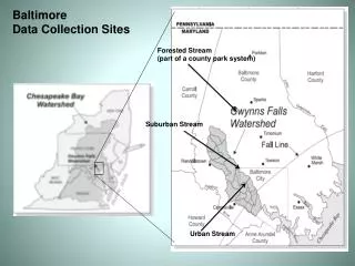
This study examines salt levels in Baltimore-area streams from three different environments: urban, suburban, and forested. Research conducted by Dr. Sujay Kaushal utilized an extensive dataset collected over 30 years, assessing seasonal variations in salt concentrations. The findings suggest that population density correlates with salt levels, with urban streams likely having the highest salinity. This analysis aims to aid in understanding environmental impacts on freshwater ecosystems and the importance of proper data representation in ecological research.

E N D
Baltimore Data Collection Sites Forested Stream (part of a county park system) Suburban Stream Urban Stream
Data from three sites… Forested Suburban Urban
Where would you expect to find the saltiest water? Forested Suburban Urban population density: 8050 people per square mile population density: 3000 people per square mile population density: 0 people per square mile
Where would you expect to find the least salty water? Forested Suburban Urban population density: 8050 people per square mile population density: 3000 people per square mile population density: 0 people per square mile
How would you test these predictions? Look at your dataset for guidance.
Dr. Sujay Kaushal’s Research • Dr. Kaushal analyzed data from streams near Baltimore considered to be urban, suburban, and forested. • He analyzed samples during each season to determine how salt levels changed. • He was lucky. The dataset was enormous, going back over 30 years. You are only looking at a subset of the data he and colleagues analyzed. Baltimore area stream Salt near storm drain
Seasonal Salt Levels in a Forested Baltimore Area Stream
Seasonal Salt Levels in a Suburban Baltimore Area Stream
Seasonal Salt Levels in an Urban Baltimore Area Stream
What is the best wayto represent the datain order to comparethe different data sets?
Why is it importantto choosean appropriate scale for your data?