Download
1 / 1
10 likes | 109 Vues
Develop a remote sensing system to estimate Nitrogen deficiency in maize crops based on aerial digital images. Acquisition of images from DuncanTech MS 3100 camera. Features include vegetation indices and chlorophyll content estimation using SPAD meter.

E N D
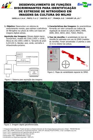
DESENVOLVIMENTO DE FUNÇÕES DISCRIMINANTES PARA IDENTIFICAÇÃO DE ESTRESSE DE NITROGÊNIO EM IMAGENS DA CULTURA DO MILHO VARELLA, C.A.A.1, PINTO, F. A. C. 2, SANTOS, N.T. 3 , FRANÇA, G.E.4, KHOURY JR.,J.K. 5 1. Objetivo: Desenvolver um sistema de sensoriamento remoto, para estimar a deficiência de Nitrogênio na cultura do milho com base em imagens digitais aéreas. Aquisição das Imagens: Câmera digital marcaDuncanTech, modelo MS 3100 (1392C x 1039L). Altura do vôo:1000 e 2000 m. Tamanho do pixel: 0,25-0,50 m. Bandas: azul, verde, vermelho e infravermelho-próximo. • Características das Imagens: As características formarão um vetor composto por índices de vegetação do dossel da cultura (NDVI, RNIR, GNIR, ARVI, WDVI, SAVI, TSAVI, MSAVI). • Teor de clorofila: A variabilidade do teor de clorofila foi estimada com uso do SPAD (medidor de clorofila). Foram amostradas 13 plantas a cada 15 m no interior da cultura. Figura 2. Mapa da variabilidade espacial do SPAD. Figura 1. Sistema para aquisição das imagens. Figura 3. Imagem digital georeferenciada. 1 Pesquisa financiada pelo Projeto de Apoio ao Desenvolvimento de Tecnologias Agropecuárias para o Brasil - PRODETAB 030 2 Prof., MS, UFRRJ, Doutorando em Engenharia Agrícola - DEA-UFV. Bolsista PICDT/CAPES. e-mail: varella@vicosa.uf.br. 3 Prof., Ph.D., Departamento de Engenharia Agrícola da UFV. 4 Prof., Ph.D., Departamento de Informática da UFV. 5 Pesquisador, PhD., EMBRAPA Milho e Sorgo. 6 Doutorando em Engenharia Agrícoala - DEA-UFV.