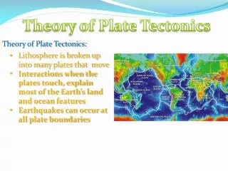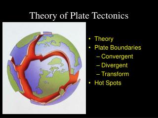
Plate Tectonics Theory
Plate Tectonics Theory. Who started the theory?. http://blue.utb.edu/paullgj/physci1417/Lectures/Plate_Tectonics.html. Alfred Wegener (pronounced, “Vagener”).

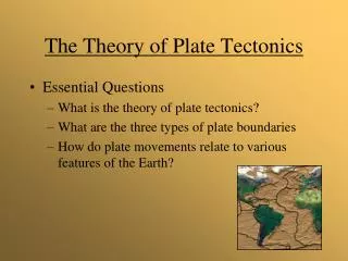
Plate Tectonics Theory
E N D
Presentation Transcript
Who started the theory? http://blue.utb.edu/paullgj/physci1417/Lectures/Plate_Tectonics.html Alfred Wegener (pronounced, “Vagener”) Wegener noticed that continents fit together like puzzle pieces. He proposed a theory that the continents moved over time, called the “Theory of Continental Drift.”
Six types of evidence noted by Wegener are shown here. The next several slides explain the evidence. Complete your chart showing how the evidence supports the Theory of Continental Drift.
Glacial Evidence Scratches on rocks show glacial movement Places with warm climates have evidence that they were once covered by icy glaciers. Some of these places are too hot to have glaciers today. If the continents were together at the south pole (as shown above), they could have been cold. This supports the theory by showing that the continents have moved from the south pole to the present-day locations. U-shaped valleys show the passage of glaciers in the past that tore away mountain sides.
Fossil Evidence http://www.indiana.edu/~geol116/week7/platefit.jpg Matching fossils of plants and animals are found on continents that are very far apart today. This supports the theory because it looks like those places with matching fossils used to be together.
Mountain and Rock Evidence In many places, mountain chains and rocks on different continents match up. This supports the theory because it looks like they used to be together.
Coal Field Evidence Coal fields in Europe match up with coal fields in North America. This makes it look like they used to be together
Alfred Wegener’s Theory of Continental Drift was not accepted by scientists of his time. His theory was rejected because he could not explain what force could be moving the continents. He died in 1930 on an expedition in Greenland. When the Theory Plate Tectonics was developed in the 1950’s, Alfred Wegener was given credit for proposing the original idea. http://en.wikipedia.org/wiki/Alfred_Wegener http://www.awi.de/en/news/press_releases/detail/item/greenlandic_special_stamp_featuring_alfred_wegener/?cHash=4735140cb3e8f5bacb15e1ef3880f82b
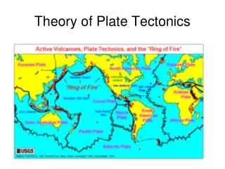
Modern evidence supporting the Theory of Plate Tectonics The next slides provide support for the Theory of Plate Tectonics. This theory states that the Earth’s crust is made out of plates that move around on the surface of the globe. Use the slides to complete the chart.
Volcano locations show us where plates meet. Volcanic Evidence
Current earthquake locations also show where plates meet. Click the link below to view current earthquake data: Current earthquake locations also show where plates meet.
Over time, earthquake locations form patterns that show plate boundary locations. This map shows worldwide earthquake locations. The locations show the edges of the plates that make up the earth’s crust. Click this link to view the latest version of this map: http://neic.usgs.gov/neis/qed/
GIS Evidence: GIS allows us to gather data on movement of plates. Each spot is monitored using GPS, and we can measure the movement over time. On the map to the left, longer arrows show faster movement and shorter arrows show slower movement. Arrows also show direction of movement.
This shows how the locations of the continents has changed over time.
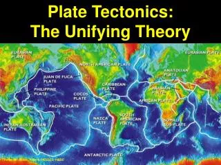
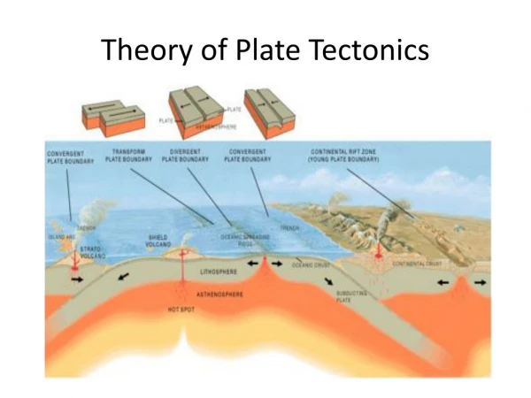
Plate Boundary Types A plate boundary is a place where the edges of different plates meet. Follow this link to learn about the different types of plate boundaries. Complete the Plate Tectonics Boundaries Chart. Note that on this website, Transform Plate Boundaries are called “Conservative” boundaries. http://scign.jpl.nasa.gov/learn/plate.htm
http://www.suu.edu/faculty/colberg/Hazards/PlateTectonics/PlateBoundaries.jpghttp://www.suu.edu/faculty/colberg/Hazards/PlateTectonics/PlateBoundaries.jpg Three types of plate boundaries are shown here. Use this to begin your chart on plate boundaries, along with the next several slides.
As you examine the next several slides, find the types of land features that are found at each of the 3 plate boundaries. Add them to complete your chart.
Divergent plates Convergent Plates
How did plate tectonics affect our area? As plates pushed together, the mountains formed. Video Clip – click below
Folding during the Alleghenian mountain-building episode Post mountain-building erosion to the ridges and valleys seen today.
The road cut through Sideling Hill shows how layers of rock that were once flat were deformed when plates pushed together.
Frederick Washington County Mountains Middletown
Notice the wrinkle-shaped mountains running through western Maryland.